[VIDEO] Pakistan Launches EO-2 Satellite: Indigenous ISR Breakthrough Deepens Sino-Pak Space Alliance, Shifts South Asia Security Balance
Launched aboard China’s Smart Dragon-3 from Yangjiang, Pakistan’s second indigenous Electro-Optical satellite strengthens sovereign ISR capabilities, enhances dual-use disaster management functions, and recalibrates the regional intelligence balance amid India’s expanding RISAT constellation.

(DEFENCE SECURITY ASIA) — Pakistan has successfully launched its second indigenous Electro-Optical satellite, EO-2 from China’s Yangjiang Seashore Launch Center, marking a decisive inflection point in Islamabad’s pursuit of strategic autonomy in space-based intelligence, surveillance and reconnaissance, and fundamentally altering the technological and security equation across South Asia’s increasingly contested geostrategic environment.
“Pakistan’s second indigenous EO-2 satellite has been successfully launched,” declared the Space and Upper Atmosphere Research Commission (SUPARCO), describing the mission as a “milestone” in expanding the national satellite fleet, while a senior official underscored its significance by stating, “This marks Pakistan’s fifth Earth observation satellite and the second indigenous Electro-Optical satellite, launched from the Yangjiang Seashore Launch Centre,” thereby framing the achievement as both technological consolidation and sovereign capability expansion.
Another official emphasized the operational implications by noting its role in “strategic planning and disaster preparedness,” while the Pakistan Strategic Forum characterized the deployment as “A major boost for disaster management, agriculture & national security,” statements that collectively embed EO-2’s civilian and military dual-use function at the heart of Pakistan’s evolving space-security doctrine.
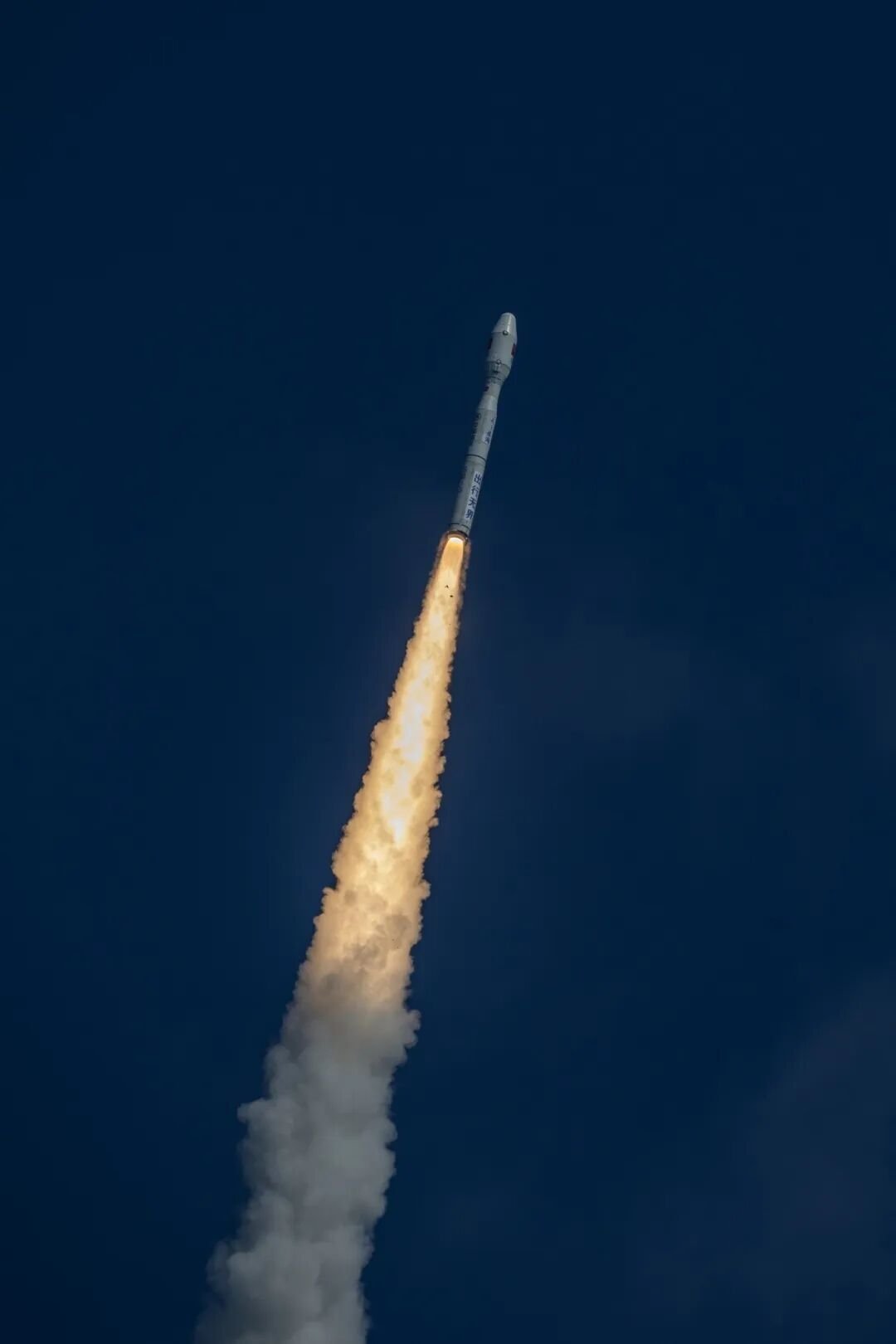
The orbital insertion of EO-2 into a sun-synchronous orbit aboard China’s Smart Dragon-3 carrier rocket not only strengthens Islamabad’s Earth observation infrastructure but symbolically reinforces what Beijing and Islamabad repeatedly describe as an “ironclad” strategic partnership extending from the China-Pakistan Economic Corridor to high-end aerospace and space cooperation.
In a region where India’s expanding satellite constellation, including RISAT-series radar imaging platforms, enhances New Delhi’s ISR envelope along the Line of Control and the Arabian Sea, Pakistan’s EO-2 represents a calibrated response designed to mitigate asymmetric informational disadvantages and elevate real-time situational awareness across both conventional and hybrid threat environments.
The sea-based launch from waters off Yangjiang in Guangdong Province at 2:37 p.m. Beijing Time further demonstrates China’s growing preference for maritime orbital deployments that circumvent terrestrial launch constraints, enhance flexibility, and reduce geopolitical exposure, while simultaneously offering Pakistan access to advanced launch modalities unavailable domestically.
With an estimated programmatic investment running into hundreds of millions of U.S. dollars—the EO-2 initiative signals Islamabad’s willingness to allocate strategic capital toward sovereign space infrastructure as a force multiplier for both national development and defense resilience.
Pakistan’s EO-2 deployment resonates as part of a broader pattern in which emerging powers leverage partnerships with China to acquire high-resolution imaging capabilities traditionally monopolized by major spacefaring states, thereby accelerating the diffusion of space-enabled ISR power into secondary but strategically pivotal theaters.
The Launch Architecture: Sea-Based Orbital Deployment and Strategic Flexibility
The EO-2 satellite, also designated PRSC-EO2 under the Pakistan Remote Sensing Satellite program, was propelled into a precise sun-synchronous orbit aboard China’s Smart Dragon-3 (SD-3) solid-fuel commercial launcher, a vehicle engineered for rapid-response, cost-effective small satellite deployments that align with Beijing’s expanding commercial and strategic space ambitions.
By participating in its first sea-based launch operation, Pakistan not only diversified its access to orbit but also signaled confidence in China’s evolving maritime launch ecosystem, which minimizes weather-related disruptions, reduces airspace congestion, and provides strategic deniability advantages in sensitive geopolitical contexts.
SUPARCO confirmed successful satellite separation and orbital insertion, stating that all mission parameters met objectives, an outcome that underscores the maturing reliability of Pakistan’s domestically integrated satellite design architecture despite continued dependence on Chinese launch infrastructure.
The multinational character of the mission, with EO-2 flying alongside six additional payloads, illustrates how China’s commercial space ecosystem increasingly functions as a geopolitical platform facilitating strategic alignment among partner states within the Belt and Road Initiative framework.
Pakistan’s earlier launch of EO-1 in January 2025 from Jiuquan aboard a Long March-2D rocket established the foundation for this tandem electro-optical architecture, but EO-2’s sea-based deployment introduces a qualitative evolution in operational flexibility and mission assurance.
The offshore launch approach mirrors global precedents such as Sea Launch, yet China’s adaptation of maritime platforms to support vehicles like the SD-3 reflects a deliberate effort to normalize flexible, distributed launch operations that enhance survivability and responsiveness in contested environments.
For Islamabad, lacking indigenous orbital launch capability, reliance on Chinese infrastructure remains a structural constraint; however, the strategic calculus appears rooted in accelerated capability acquisition rather than delayed autonomy, prioritizing immediate ISR effectiveness over symbolic launch independence.
In financial terms, while precise launch costs remain undisclosed, comparable small-satellite deployments aboard commercial solid-fuel rockets typically range between USD 15–30 million (approximately RM70–RM140 million), indicating that EO-2 represents a cost-efficient yet strategically potent enhancement to Pakistan’s space-based surveillance matrix.
Technical Architecture: Electro-Optical Precision and Indigenous Engineering Maturation
EO-2 represents the most advanced iteration of Pakistan’s electro-optical remote sensing lineage, reportedly delivering sub-meter spatial resolution capabilities combined with multispectral imaging bands that significantly exceed EO-1’s baseline electro-optical performance envelope.
Operating in sun-synchronous orbit, EO-2 benefits from consistent lighting geometry that ensures optimal image contrast and surface feature discrimination, enhancing change detection, infrastructure mapping, and border monitoring precision across diverse terrain typologies.
SUPARCO’s in-house Satellite Research and Development Center (SRDC) in Lahore conceived, designed, and integrated EO-2, reinforcing Islamabad’s narrative of indigenous technological maturation even as external launch dependencies persist.
The satellite integrates advanced attitude determination and control subsystems, high-throughput data downlink architecture, and improved payload management algorithms designed to maximize imaging continuity and reduce latency between acquisition and ground station processing.
SUPARCO emphasized that “EO-2 observes Earth under different illumination conditions, improving surface feature interpretation, change detection, and imaging continuity,” a statement that underscores the satellite’s capacity to perform complementary observations under varying sun angles and seasonal shifts.
Compared to EO-1, EO-2 introduces enhanced revisit frequency when operating in tandem, creating a quasi-constellation effect that mitigates temporal gaps and improves redundancy for time-sensitive ISR and disaster-response operations.
The integration of multispectral sensors enables vegetation indexing, hydrological analysis, and urban sprawl assessment while simultaneously offering high-resolution optical surveillance potential across contested border regions and maritime approaches.
In strategic terms, sub-meter imaging resolution, even at conservative estimates, provides actionable intelligence capabilities sufficient for identifying military installations, troop concentrations, airfield expansions, and logistics movements, thereby reinforcing deterrence credibility within a volatile India-Pakistan security matrix.
Dual-Use Imperatives: Civilian Resilience and Strategic ISR Enhancement
EO-2’s civilian mandate encompasses resource management, urban planning, agricultural monitoring, and disaster response, areas of critical importance for a climate-vulnerable state that experienced catastrophic flooding in 2022 with economic losses exceeding USD 30 billion (approximately RM140 billion).
High-fidelity satellite imagery enhances crop yield forecasting, irrigation optimization, and drought monitoring, contributing to food security planning in a nation where agriculture constitutes a significant share of GDP and rural employment.
Urban expansion in megacities such as Karachi and Lahore can now be mapped with greater precision, supporting infrastructure development and mitigating unregulated sprawl that exacerbates environmental degradation and disaster vulnerability.
Environmental monitoring of deforestation in the Hindu Kush and pollution levels in the Indus Basin benefits from EO-2’s multispectral capabilities, providing longitudinal datasets critical for policy calibration and international climate reporting obligations.
From a defense perspective, EO-2’s high-resolution optical imaging significantly strengthens ISR capacity along the Line of Control with India, enabling improved monitoring of cross-border troop deployments, artillery positions, and infrastructure build-ups.
The Pakistan Strategic Forum’s assertion that EO-2 is “A major boost for disaster management, agriculture & national security” encapsulates the satellite’s dual-use architecture, blending developmental objectives with sovereign security imperatives.
In Balochistan and other restive regions, EO-2 enhances counterinsurgency surveillance capabilities by improving terrain mapping and movement detection across vast, sparsely populated expanses that challenge conventional ground-based reconnaissance.
Within the broader Indo-Pacific security ecosystem, where satellite-enabled ISR increasingly underpins maritime domain awareness, EO-2 contributes to Pakistan’s ability to monitor Arabian Sea approaches and protect sea lines of communication linked to the China-Pakistan Economic Corridor.
Geopolitical Ramifications: Sino-Pak Space Synergy and Regional Power Equations
The EO-2 launch exemplifies the deepening of Sino-Pak space collaboration under agreements that extend beyond satellite launches to astronaut training, with a Pakistani astronaut slated for participation aboard China’s Tiangong space station in late 2026.
Chinese state media described the cooperation as an “important achievement of China-Pakistan space cooperation,” reinforcing the narrative of technological integration and strategic alignment between the two states.
In New Delhi, Pakistan’s expanding electro-optical constellation is likely to be interpreted as part of an accelerating ISR competition, especially as India continues to expand its own constellation including RISAT and Cartosat platforms.
For Washington, the integration of partner states into China’s space ecosystem may reinforce concerns regarding the diffusion of dual-use technologies that could indirectly augment Beijing’s broader strategic positioning across Eurasia.
Within ASEAN, Pakistan’s model demonstrates how mid-tier states can leverage great-power partnerships to accelerate indigenous capability acquisition without incurring the full financial burden of independent launch infrastructure development.
The financial valuation of Pakistan’s cumulative Earth observation assets, including PRSS-1, PakTES-1A, EO-1 and EO-2, likely exceeds USD 300–500 million (approximately RM1.4–RM2.3 billion), reflecting sustained strategic investment in sovereign ISR architecture.
By embedding space cooperation within the broader China-Pakistan Economic Corridor, Islamabad integrates terrestrial infrastructure security with orbital surveillance capacity, creating a vertically aligned security ecosystem spanning land, sea and space domains.
In the context of QUAD strategic recalibrations and Indo-Pacific power balancing, EO-2 contributes to a subtle but measurable shift in informational equilibrium across South Asia, reinforcing Pakistan’s deterrence posture without overt escalation.
Future Trajectories: Toward Constellation Depth and Strategic Autonomy
SUPARCO’s roadmap envisions the launch of EO-3 by late 2026, completing a triad of electro-optical satellites designed to maximize revisit frequency and provide near-persistent coverage over priority theaters.
The integration of hyperspectral platforms, following HS-1’s deployment in 2025, indicates an ambition to diversify sensing modalities beyond conventional electro-optical imaging, enhancing mineral exploration, environmental analytics, and advanced surveillance capabilities.
Human spaceflight collaboration with China, including astronaut training under the China Manned Space Agency framework, signals Islamabad’s long-term aspiration to transition from satellite consumer to active participant in crewed space endeavors.
Economic multipliers derived from space-enabled data services could incrementally contribute to GDP growth by fostering downstream industries in geospatial analytics, telecommunications, and environmental modeling.
From a military perspective, a fully operational electro-optical constellation strengthens Pakistan’s ability to conduct real-time monitoring of adversarial force movements, reducing strategic surprise and enhancing crisis decision-making agility.
SUPARCO’s trajectory mirrors historical precedents in which emerging powers transitioned from foreign-assisted satellite acquisition to domestically integrated design and eventual launch capability, albeit on compressed timelines enabled by strategic partnerships.
In a global environment characterized by intensifying space militarization, Pakistan’s EO-2 deployment underscores the normalization of dual-use satellite capabilities among mid-tier states seeking to hedge against regional uncertainties.
As Islamabad prepares EO-3 and contemplates deeper integration into China’s expanding space architecture, Pakistan’s orbiting assets increasingly function not merely as technological achievements but as pillars of national sovereignty and strategic deterrence within a multipolar space order. — DEFENCE SECURITY ASIA