Satellite War Over the Gulf: Iranian ‘Strike Evidence’ Images on Damage to U.S. Bases in Bahrain, Qatar and UAE — Real Battlefield Impact or Strategic Information Warfare?
Satellite imagery circulated by Iranian state-linked media claims missile damage across key U.S. military installations in the Gulf, triggering a global verification battle over whether the images reveal real battlefield impacts or a new phase of strategic information warfare.

(DEFENCE SECURITY ASIA) — A surge of satellite imagery released by Iranian state-affiliated media outlets is rapidly transforming the military confrontation narrative across the Persian Gulf, as images claiming to depict Iranian missile strikes on U.S. military infrastructure circulate globally and force defence analysts to assess whether the evidence represents genuine battlefield damage or a sophisticated information warfare campaign.
These images—distributed primarily by Iranian state-linked broadcasters and amplified through pro-Iranian social media networks—purport to show before-and-after satellite views of multiple U.S. military facilities across Bahrain, the United Arab Emirates, and Qatar, framing the visuals as proof of successful Iranian retaliation against American force posture in the region.
The sudden appearance of these satellite images has intensified geopolitical scrutiny because they allegedly depict damage to strategic installations associated with U.S. power projection in the Gulf, including facilities linked to the U.S. Fifth Fleet headquarters in Bahrain and critical operational infrastructure at Al Dhafra Air Base in the United Arab Emirates.
Within the imagery disseminated online, Iranian media outlets present zoomed-in satellite comparisons highlighting what they describe as structural destruction, crater formations, and burn scars across installations that host American military logistics and aviation support infrastructure.
The strategic significance of these images lies not only in their claim of kinetic impact against U.S. bases but also in their potential influence on regional deterrence dynamics, as satellite imagery has increasingly become a tool of geopolitical signalling in modern military information operations.
Iranian state-affiliated outlets have circulated these satellite visuals widely across digital channels, framing them as evidence that Iranian missile strikes inflicted meaningful damage on U.S. military assets across several Gulf states.
Pro-Iranian social media accounts on platforms such as X (formerly Twitter) have further amplified the imagery, often presenting the visuals alongside captions declaring that the strikes represent retaliation against what Iranian narratives describe as American aggression.
The imagery itself is typically structured in split-screen formats showing “before” satellite photographs of intact buildings and facilities juxtaposed with “after” images allegedly showing cratered terrain, burned structures, and collapsed infrastructure.
These visuals are designed to reinforce the perception that Iranian missile forces successfully penetrated U.S. air defence layers protecting Gulf-based installations and caused structural damage to key facilities supporting American regional operations.
However, the rapid circulation of these images has triggered an equally intense debate among defence observers regarding authenticity, verification standards, and the strategic role of satellite imagery in shaping global perceptions of modern conflict.
Iranian Media Claims Damage at U.S. Fifth Fleet Headquarters in Bahrain
Satellite imagery circulated by Iranian state-affiliated outlets prominently features aerial views of Manama, Bahrain, where the U.S. Fifth Fleet maintains its regional headquarters, with zoomed-in overlays highlighting areas Iranian media claim were struck during missile attacks targeting American military infrastructure.
The imagery released online uses white rectangular highlight boxes to direct viewer attention to specific locations where Iranian outlets claim visible damage occurred, including structures described as warehouses and logistical facilities supporting American naval operations in the Gulf.
According to the visuals distributed across Iranian media channels, the “after” satellite images show areas marked by blackened surfaces, debris patterns, and crater formations that Iranian narratives present as evidence of missile impact within or near operational sections of the base.
Video clips accompanying the satellite images reportedly transition between earlier satellite photographs depicting intact infrastructure and subsequent images showing what Iranian media describe as smoke damage, structural collapse, and surface scarring.
These before-and-after comparisons are framed by Iranian media outlets as proof that Iranian missile forces successfully struck installations linked to U.S. naval logistics operations supporting the Fifth Fleet’s maritime presence in the Persian Gulf.
The visual narrative promoted by these outlets emphasises the strategic symbolism of striking infrastructure connected to the U.S. Fifth Fleet, which represents one of the central pillars of American naval power projection in the Middle East.
In these media presentations, the highlighted zones allegedly show damage concentrated around facilities Iranian outlets describe as support buildings and storage areas that play a role in sustaining U.S. naval deployments across the Gulf region.
The framing of these images is designed to reinforce Iranian claims that their missile forces are capable of targeting installations associated with American operational command structures in the region.
However, the available imagery circulated online does not independently confirm the scale or origin of the damage depicted, leaving open questions regarding whether the visuals represent verified strike impacts or manipulated interpretations of satellite data.
As a result, the images have become part of a broader strategic contest over narrative control in which satellite imagery itself functions as both a technical intelligence tool and a weapon of perception management in geopolitical competition.
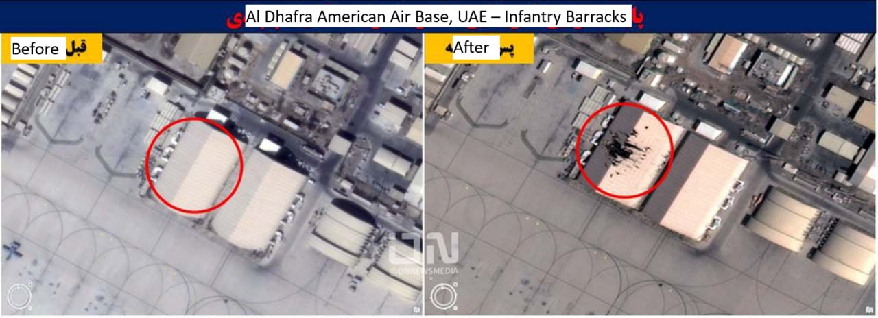
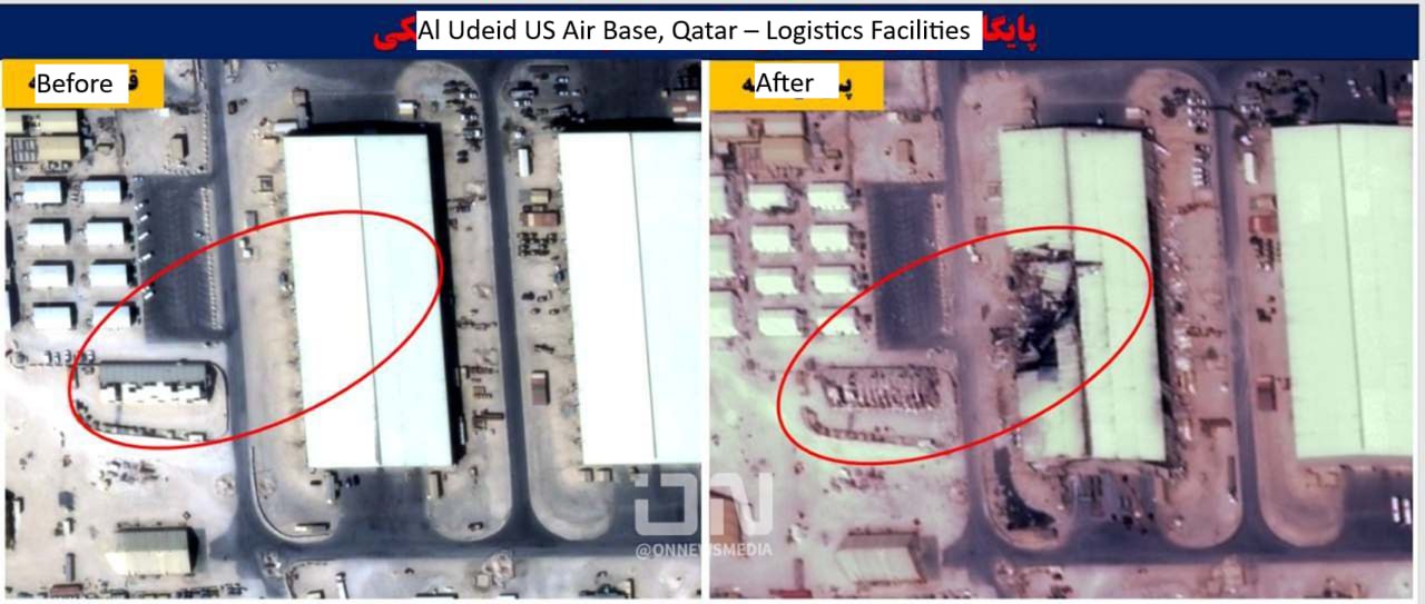
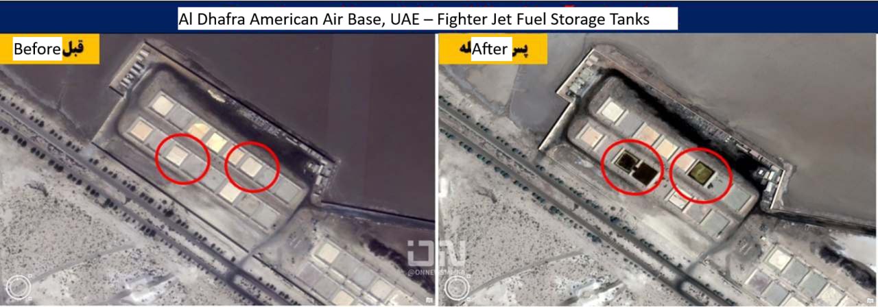
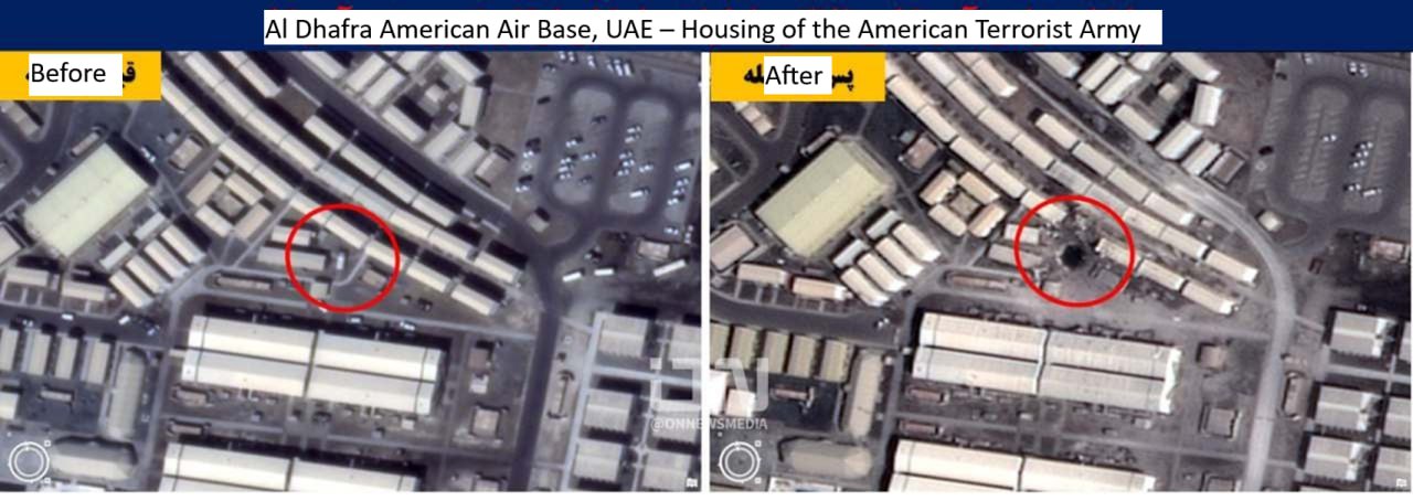
Al Dhafra Air Base Satellite Images Highlight Alleged Fuel Infrastructure Damage
Another focal point of Iranian media releases involves satellite imagery purportedly showing the aftermath of missile strikes on Al Dhafra Air Base in the United Arab Emirates, a strategic air installation supporting American air operations in the Gulf region.
The imagery distributed online uses labelled overlays describing specific locations as “Housing of the American Terrorist Army” and “Fighter Jet Fuel Storage Tanks,” indicating that Iranian narratives seek to highlight logistical infrastructure rather than runways or aircraft.
In the “before” satellite photographs presented by Iranian outlets, the targeted areas appear as intact buildings and cylindrical storage tanks, which are highlighted in red circles to indicate locations Iranian media claim were later struck by missiles.
The accompanying “after” satellite images allegedly show black scorch marks, crater formations, and structural damage within the same highlighted zones, which Iranian outlets describe as the visible aftermath of missile impacts on aviation support infrastructure.
Iranian media narratives accompanying these visuals emphasise that fuel storage infrastructure represents a critical vulnerability within modern air base operations because such facilities sustain fighter jet sortie generation and long-duration air operations.
The implication within the imagery’s presentation is that damage to fuel storage infrastructure could theoretically disrupt air base operational capacity by affecting the logistics chain supporting aircraft refuelling and maintenance activities.
However, the satellite visuals circulated by Iranian outlets provide limited contextual information regarding the timing of the images, the source of the satellite data, or independent verification of the damage claims.
This lack of verifiable metadata complicates attempts by external observers to determine whether the imagery accurately reflects strike impacts or whether the damage patterns shown may originate from unrelated factors.
Consequently, the Al Dhafra imagery has become a focal point for analysts assessing how satellite imagery can be selectively presented within state-driven information campaigns to reinforce narratives of military effectiveness.
The episode highlights how modern military conflicts increasingly unfold simultaneously in both the physical battlespace and the information domain, where imagery and perception can shape international interpretations of battlefield outcomes.
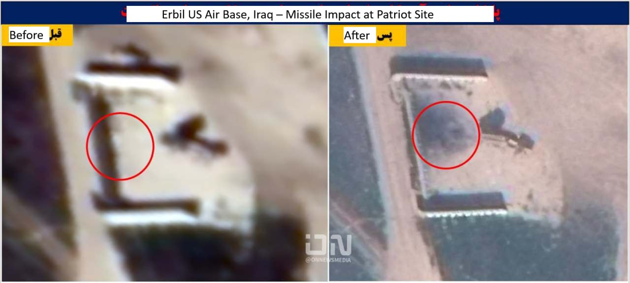
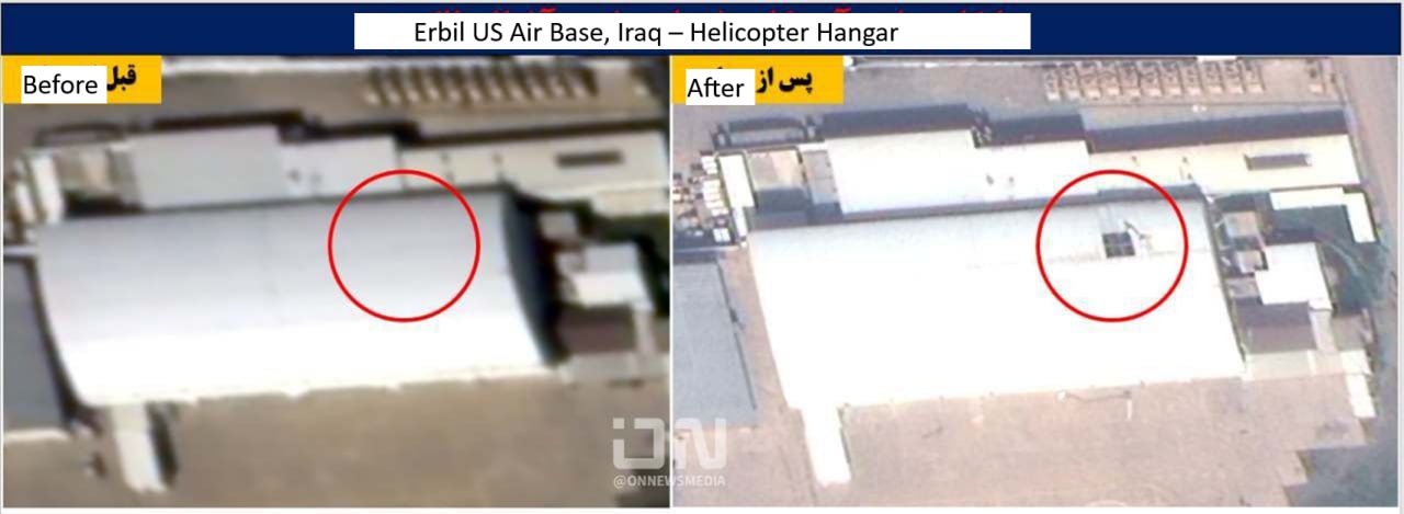
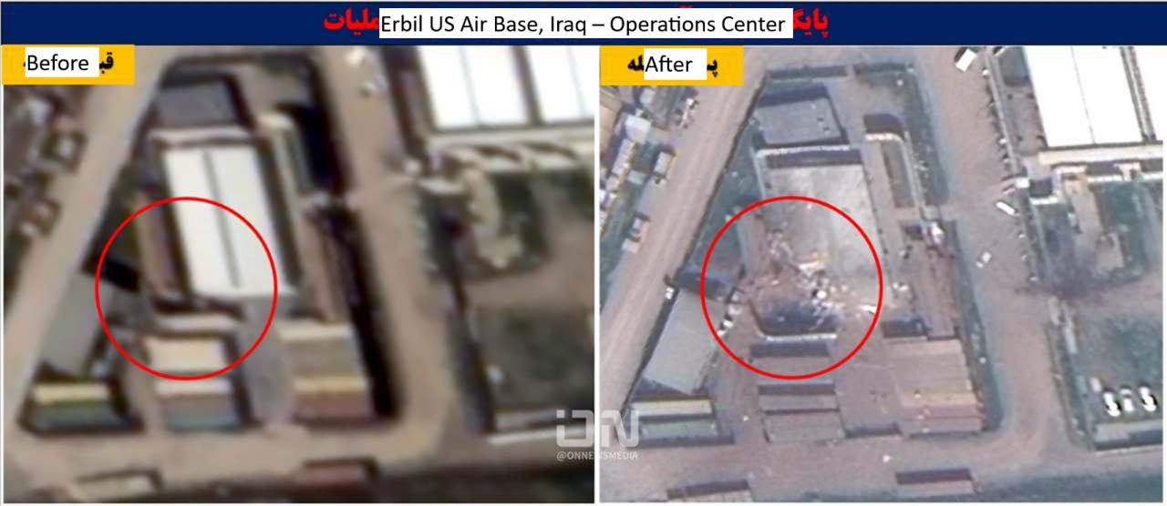
Iranian Media Expand Claims to Bases in Kuwait and Saudi Arabia
Beyond Bahrain, the UAE, and Qatar, Iranian media outlets have also circulated satellite images claiming missile impacts on American military facilities located in Kuwait and Saudi Arabia, expanding the geographic scope of the alleged strikes across the Gulf region.
These images follow the same visual structure used in earlier releases, presenting side-by-side comparisons of satellite photographs showing intact infrastructure before the alleged strikes and cratered terrain or burning structures afterward.
Captions accompanying these visuals are often displayed in both English and Persian, indicating that the imagery is designed to reach both domestic Iranian audiences and international observers monitoring developments in the Gulf.
The captions frequently frame the imagery as evidence of successful retaliation against what Iranian narratives describe as American military aggression, reinforcing the perception that Iranian missile forces have penetrated regional defence networks.
By highlighting multiple Gulf states hosting U.S. military facilities, the imagery attempts to portray Iranian missile capabilities as having regional reach across the broader American military footprint in the Middle East.
This narrative framing emphasises the idea that Iranian strike capabilities are not confined to a single installation but can potentially target multiple bases across the Gulf theatre simultaneously.
However, the imagery presented by Iranian media does not provide detailed contextual information such as the exact time of the satellite captures, the identity of the imaging satellites, or the technical parameters of the images.
Without such metadata, analysts cannot conclusively determine whether the visuals represent recent strike impacts, unrelated structural damage, or manipulated interpretations of satellite data.
The absence of independently verified geospatial analysis therefore leaves the claims in a state of informational ambiguity.
This ambiguity reflects the broader dynamics of modern geopolitical information campaigns where imagery itself becomes a contested instrument of strategic communication.
Verification Challenges and the Information Warfare Dimension
While some independent satellite imagery has reportedly corroborated limited damage to communication infrastructure and military facilities in the Gulf following Iranian strikes, the broader set of images circulated by Iranian state-linked media remains difficult to independently verify.
The presence of manipulated images within the circulating dataset reinforces the importance of rigorous verification standards when assessing satellite imagery released during periods of geopolitical tension.
In modern conflict environments, satellite imagery has become a powerful narrative tool because it conveys an impression of technical objectivity even when the interpretation of the visuals remains contested.
This dynamic creates a strategic incentive for governments and political actors to release selectively framed imagery that supports their preferred narrative of battlefield outcomes.
The images released by Iranian outlets therefore function not only as alleged evidence of strike damage but also as part of a broader information campaign aimed at shaping international perceptions of military capability and strategic resolve.
For defence analysts and policymakers monitoring the situation, the key challenge lies in distinguishing between verifiable geospatial intelligence and imagery that may have been manipulated or misinterpreted.
This challenge is amplified by the rapid speed at which satellite images can now be distributed globally through social media platforms and digital news ecosystems.
As a result, satellite imagery released during military confrontations increasingly operates within a hybrid battlespace where technical intelligence, strategic messaging, and geopolitical narratives overlap.
The episode involving Iranian satellite imagery claims therefore illustrates the evolving intersection between military operations and information warfare in the digital era.
Within this environment, the interpretation of satellite images can influence global perceptions of power, deterrence credibility, and operational success even before independent verification becomes available.
Consequently, the controversy surrounding these images underscores how modern conflicts extend beyond kinetic engagements into the domain of narrative competition where information itself becomes a strategic weapon.