Iran Buys Chinese Spy Satellite to Map U.S. Bases Before Middle East Missile Strikes
Leaked documents suggest Iran’s Revolutionary Guard used the Chinese-built TEE-01B reconnaissance satellite to monitor American air bases, naval facilities and logistics hubs before and after missile and drone attacks across the Middle East.

(DEFENCE SECURITY ASIA) — Iran’s covert acquisition of a Chinese-built surveillance satellite has raised the possibility that American military installations across the Middle East were systematically mapped before recent Iranian missile and drone attacks.
Leaked operational documents indicate the Islamic Revolutionary Guard Corps Aerospace Force used the TEE-01B reconnaissance satellite to photograph, coordinate and repeatedly monitor key U.S. military facilities throughout early 2026.
The reported surveillance campaign matters strategically because it suggests Iran may already possess an indigenous, continuously accessible orbital intelligence capability independent from traditional civilian satellite networks.

The leaked files reportedly contain timestamped imagery, coordinate grids and orbital calculations linked directly to Iranian planning cycles before and after retaliatory strikes during the March 2026 regional confrontation.
Those strikes followed the wider conflict triggered after U.S. and Israeli operations against Iranian targets beginning during late February, creating an escalating cycle of military action across the region.
According to the leaked material, Iranian commanders used the satellite both to select vulnerable military infrastructure and to measure operational damage after attacks concluded.
That capability potentially shortens Iranian targeting timelines, improves battle damage assessment and reduces dependence upon foreign intelligence support during future crises involving American regional forces.
Chinese officials rejected the allegations immediately, yet the absence of public comment from Washington, the Pentagon, the CIA and involved Chinese commercial firms has intensified international scrutiny.
The controversy therefore extends beyond a single satellite because it may reveal a wider Iranian-Chinese military-technical partnership operating quietly beneath nominally commercial space arrangements.
The TEE-01B satellite, also known as Earth Eye 1, was secretly transferred to the Islamic Revolutionary Guard Corps Aerospace Force during late 2024.
If confirmed, the arrangement would mark one of the first known cases in which a commercially exported Chinese satellite was integrated directly into an Iranian military targeting architecture.
The development also suggests future Middle Eastern conflicts may increasingly be shaped by affordable commercial space systems capable of providing near-real-time intelligence to non-Western military actors.
READ: China’s AI Satellite Maps Are Allegedly Helping Iran Target U.S. Bases, Triggering Urgent Pentagon Force Protection Fears
The Satellite Transfer That Quietly Changed Iran’s Military Space Capabilities
The satellite had originally been built and launched by Chinese commercial company Earth Eye Co., known domestically as Mumei Xingkong Keji, before eventual transfer into Iranian operational control.
Instead of requiring an Iranian launch campaign, the system reportedly used an “in-orbit delivery” arrangement allowing control to pass after successful orbital insertion from China.
That model carries considerable strategic value because it enables sanctioned states to acquire advanced orbital platforms without exposing domestic launch facilities or vulnerable procurement networks.
TEE-01B was launched aboard a Chinese Ceres-1, or Gushenxing-1, rocket on June 6, 2024, entering a sun-synchronous orbit approximately 545 kilometres above Earth.
A sun-synchronous orbit allows repeated observation of identical locations under consistent lighting conditions, significantly improving the usefulness of imagery for military planning and comparative analysis.
The arrangement reportedly also granted the IRGC access to a broader network of commercial ground stations operated by Beijing-based satellite services company Emposat.
Emposat controls satellite communication and data facilities distributed across Asia, Latin America and other regions, potentially providing Iran with resilient, geographically dispersed mission support.
Such access would reduce Iranian dependence upon domestic ground stations vulnerable to cyberattack, electronic disruption or conventional military strikes during wartime contingencies.
By transferring operational control directly to the IRGC Aerospace Force rather than Iran’s civilian space establishment, the programme appeared explicitly designed for military purposes.
Why TEE-01B Gave Iran A More Dangerous Intelligence Advantage
TEE-01B reportedly provides panchromatic imagery with resolution between 0.5 and 0.52 metres, approaching the quality achieved by leading Western commercial observation satellites.
At that resolution, aircraft shelters, parked combat aircraft, fuel storage facilities, mobile missile launchers and hardened command structures become identifiable with considerable precision.
The satellite additionally provides multispectral imagery at roughly 2.1 metres resolution, enabling broader terrain analysis and identification of infrastructure changes across military compounds.
Its swath width reportedly exceeds 14.8 kilometres at nadir, allowing extensive sections of large air bases or naval installations to be photographed simultaneously.
Combined together, those characteristics create a reconnaissance platform capable of repeatedly observing both fixed facilities and changing operational patterns across multiple countries.
Military value increases further when imagery is paired with coordinate libraries, orbital timing analysis and pre-programmed target lists generated before missile operations.
The leaked documents reportedly contained precisely those elements, indicating Iranian planners developed an integrated targeting cycle rather than using isolated satellite photographs.
Such a cycle allows commanders to compare baseline imagery against later strike results, identifying destroyed infrastructure, surviving assets and requirements for follow-on attacks.
Iran therefore appears to have used TEE-01B not simply as a passive surveillance instrument, but as a central component within operational strike planning.
Prince Sultan, Bahrain And Jordan Became Central Targets Of Iranian Orbital Surveillance
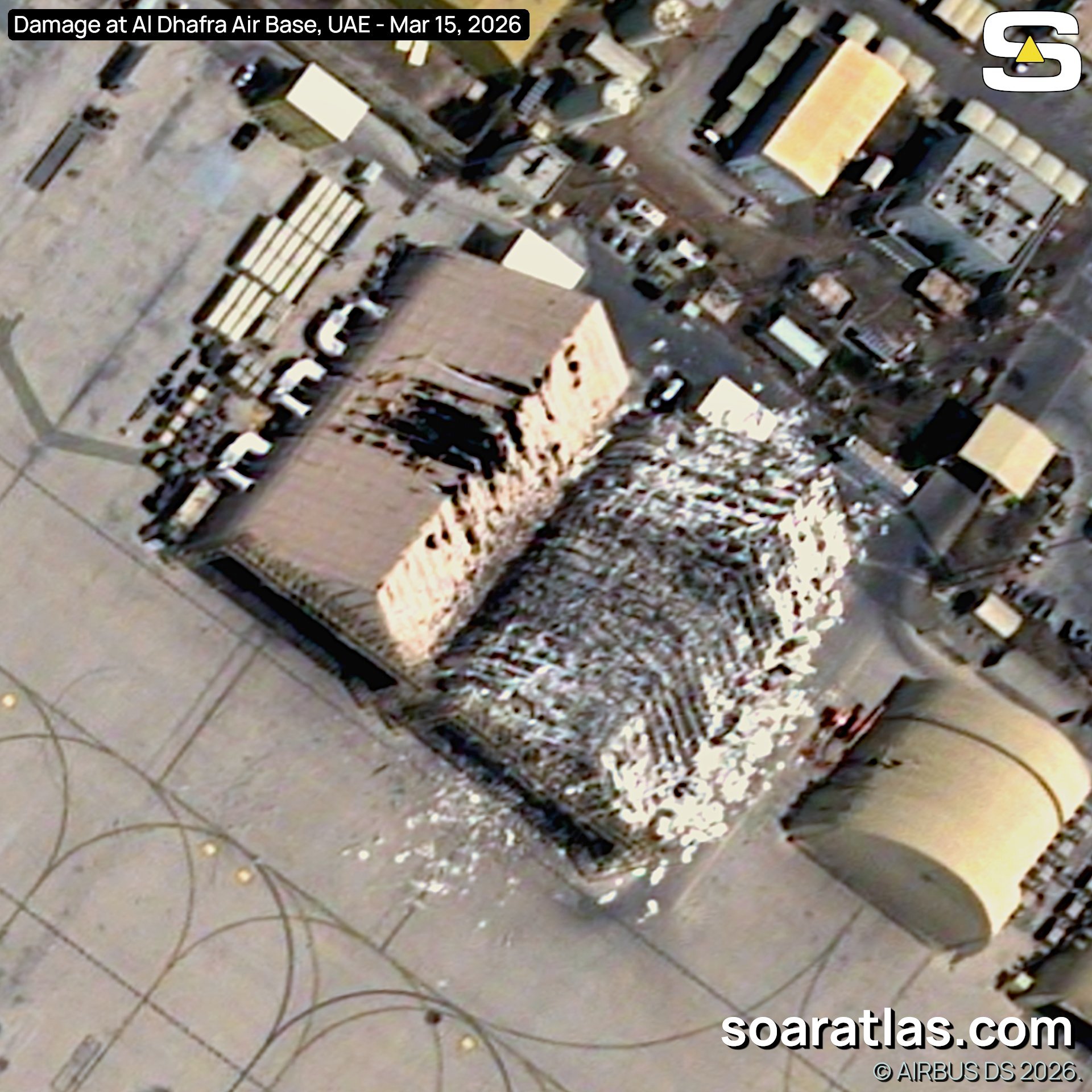
Among the most significant locations reportedly monitored was Prince Sultan Air Base in Saudi Arabia, where American aircraft were photographed between March 13 and March 15.
The timing proved especially sensitive because U.S. aircraft at Prince Sultan were reportedly hit during Iranian attacks on March 14, later publicly acknowledged by President Donald Trump.
The satellite also reportedly monitored Muwaffaq Salti Air Base in Jordan, another important American and allied operating location supporting regional air operations.
Additional imagery focused upon areas surrounding the headquarters of the U.S. Fifth Fleet near Manama, Bahrain, indicating maritime facilities were equally important.
Leaked material also referenced sites near Erbil airport in Iraq during the same period surrounding Iranian Revolutionary Guard strike claims there.
The wider surveillance campaign reportedly extended beyond those facilities toward American and allied sites located in Kuwait, Oman and Djibouti.
That geographic spread suggests Iran was building a regional intelligence picture covering air, naval and logistical infrastructure supporting U.S. military operations.
Rather than concentrating exclusively upon immediate wartime targets, Tehran appears to have mapped an interconnected network of facilities across several operational theatres.
Such mapping would enable Iranian commanders to identify reinforcement routes, logistical chokepoints and potential secondary targets during any prolonged regional confrontation.
How Satellite Imagery Changed Iranian Strike Planning And Damage Assessment
The leaked documents indicate Iranian commanders used the imagery both before attacks and immediately afterward, creating a closed reconnaissance-strike-assessment cycle.
Before strikes occurred, the satellite reportedly supplied coordinate lists and time-stamped images helping commanders determine optimal launch windows and target priorities.
Because the satellite occupied a predictable sun-synchronous orbit, Iranian planners could anticipate future overpasses and synchronise missile launches with reconnaissance availability.
That timing advantage would improve accuracy against fixed facilities while allowing commanders to monitor whether valuable American aircraft remained present beforehand.
Following the attacks, fresh imagery reportedly enabled Iranian analysts to determine whether hangars, aircraft shelters or support infrastructure had been successfully damaged.
Battle damage assessment has historically been one of Iran’s major intelligence weaknesses because Tehran previously relied heavily upon open-source imagery or foreign reporting.
Possession of an independently controlled orbital platform therefore could significantly improve Iranian confidence when deciding whether additional attacks remain necessary.
The system may also reduce delays between separate strike waves, potentially allowing Iranian forces to exploit temporary vulnerabilities before American defences recover.
In practical military terms, TEE-01B appears to have given Iran a more complete intelligence architecture than previously acknowledged publicly.
READ: Satellite Images Confirm Iranian Missile Hit Inside Al Dhafra Air Base — Craters, Destroyed Barracks Raise Alarming Questions Over Gulf Air-Defence Shield
China’s Denial Cannot Eliminate The Wider Strategic Questions
China’s foreign ministry rejected the allegations outright, describing them as untrue and accusing unnamed parties of spreading fabricated rumours and malicious associations.
The Chinese embassy in Washington issued a similar response, condemning what it called speculative and insinuative disinformation linking Beijing to Iranian military operations.
Nevertheless, Chinese denials have not removed questions surrounding the commercial export structure used to transfer the satellite into Iranian possession.
Because the transaction reportedly occurred after launch through an in-orbit delivery model, the arrangement occupied an ambiguous space between commerce and military assistance.
That ambiguity matters strategically because Chinese firms can potentially argue they merely sold a commercial imaging platform rather than directly supporting military action.
Yet the reported decision to place operational control directly under the IRGC Aerospace Force strongly undermines any purely civilian interpretation.
No public comments have emerged from the White House, CIA, Pentagon, Earth Eye Co. or Emposat regarding the leaked allegations.
The absence of official American confirmation leaves important uncertainties unresolved, particularly because independent verification of the leaked documents remains unavailable publicly.
Even so, the reported episode illustrates how commercially available satellites may increasingly provide sanctioned states with strategic reconnaissance once limited to major powers.
The reported transfer model could therefore become an attractive template for other states seeking advanced intelligence capabilities while avoiding direct procurement from major military suppliers.
If such arrangements continue expanding through ostensibly civilian Chinese space companies, existing export-control regimes may struggle to distinguish between commercial remote sensing and covert military enablement.
The controversy consequently raises wider questions about whether future conflicts will increasingly be shaped by privately operated orbital systems functioning as undeclared extensions of national military power.