China’s AI Satellite Maps Are Allegedly Helping Iran Target U.S. Bases, Triggering Urgent Pentagon Force Protection Fears
DIA officials believe Chinese company MizarVision’s AI-enhanced satellite imagery is enabling Iran’s IRGC to identify Patriot, THAAD, aircraft shelters and fuel depots across U.S. and allied bases, dramatically shortening the missile and drone targeting cycle.

(DEFENCE SECURITY ASIA) — The U.S. military’s regional force posture is confronting an unprecedented vulnerability because commercially available Chinese geospatial datasets are allegedly shortening Iran’s missile targeting cycle across multiple Middle Eastern battlefronts.
U.S. Defense Intelligence Agency officials believe the Iranian Revolutionary Guard Corps is actively exploiting Chinese-generated satellite imagery, raising immediate concerns regarding force protection, regional deterrence, and American military survivability.
According to early April 2026 intelligence assessments, Chinese geospatial company MizarVision has published AI-enhanced imagery identifying Patriot batteries, THAAD systems, aircraft shelters, fuel depots, command centres, and logistical infrastructure.
A DIA official warned that the activity represented “a Chinese company, we believe maliciously, providing intelligence on an open-source platform,” directly increasing risks confronting American personnel and allied military installations.
Another intelligence official stated that the Iranian Revolutionary Guard Corps was monitoring these datasets continuously, allowing missile and drone planners to prioritise valuable targets with significantly greater precision and operational confidence.
The allegation carries extraordinary geopolitical implications because it suggests modern battlefield intelligence can now be generated, distributed, and weaponised globally without governments directly transferring classified military information.
The assessment is particularly alarming because it indicates that commercially available imagery can now compress the traditional intelligence-to-strike cycle from several days into only a few operational hours.
DIA officials reportedly believe the IRGC Aerospace Force is using these datasets not merely to identify targets, but also to analyse deployment patterns, operational routines, and periods of maximum vulnerability.
Such capabilities would enable Iranian missile and drone units to shift from broad saturation attacks toward highly selective strikes against air-defence radars, aircraft parking areas, maintenance shelters, and fuel storage facilities.
The concern has intensified following reports that several military assets previously highlighted within MizarVision’s imagery were later targeted during Iranian missile and unmanned aerial vehicle attacks.
For American commanders, the development threatens to undermine the survivability of major regional installations including Prince Sultan Air Base in Saudi Arabia, Diego Garcia, and other forward-operating locations across the Middle East.
The episode also reinforces wider fears within Western defence circles that China’s rapidly expanding civil-military fusion model is creating indirect pathways through which commercially generated technology can alter the strategic balance without overt state involvement.
READ: China’s Jilin-1 Spy Satellite Network Is Watching the U.S.–Iran War in Real Time — Beijing Quietly Harvests American Warfighting Data for Future Indo-Pacific Conflict
How MizarVision Is Reshaping the Modern Targeting Cycle
MizarVision, founded during 2021 with an estimated 5.5 percent Chinese government ownership stake, publicly describes its mission as democratising geospatial intelligence through artificial intelligence-enhanced commercial satellite imagery.
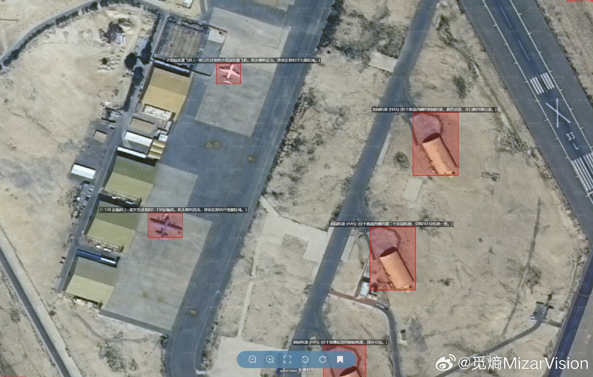
The company reportedly publishes high-resolution imagery across open-source platforms including Weibo, combining commercial satellite photographs with machine-learning algorithms trained specifically upon recognisable military signatures and battlefield infrastructure.
Those algorithms reportedly identify and label aircraft revetments, Patriot interceptors, THAAD launchers, radar installations, hardened shelters, ammunition storage sites, troop concentrations, maintenance zones, fuel farms, and transportation corridors.
Each image reportedly includes detailed geospatial metadata allowing coordinates, asset categories, and deployment patterns to be integrated directly into missile targeting software or unmanned aerial vehicle mission planning.
Although the imagery itself originates largely from commercial providers such as Planet Labs, MizarVision’s artificial intelligence reportedly transforms otherwise generic photographs into immediately usable operational intelligence products.
Analysts consider the company’s unusually rapid and free dissemination of imagery strategically significant because profit-driven firms rarely publish sensitive military analysis without obvious commercial incentives.
That behaviour has intensified concerns surrounding China’s civil-military fusion strategy, under which private technology companies can support wider national objectives without overtly functioning as state intelligence organisations.
China’s foreign ministry has rejected such accusations, describing MizarVision’s publications as routine commercial activity based entirely upon legally accessible, publicly available, open-source geospatial information.
Why DIA Officials Believe the IRGC Is Exploiting the Data
U.S. Defense Intelligence Agency officials assess that the IRGC Aerospace Force, which controls Iran’s ballistic missile and drone arsenal, is actively monitoring MizarVision’s published imagery.
American officials believe those datasets enable Iranian planners to move beyond broad saturation attacks toward more selective strikes against high-value military enablers and logistical infrastructure.
Instead of merely targeting entire airfields, Iranian operators can reportedly isolate specific radar sites, aircraft parking areas, maintenance shelters, fuel depots, command centres, and defensive missile batteries.
DIA analysts also believe the imagery supports pattern-of-life analysis by allowing Iranian planners to identify when aircraft deployments, troop concentrations, or logistical activity reach peak vulnerability.
That analytical advantage could allow the IRGC to coordinate missile launches and drone strikes during narrow operational windows when defensive systems are least prepared.
Officials additionally believe the datasets help validate target coordinates, optimise flight routes, and refine strike sequencing before ballistic missiles or one-way attack drones are launched.
A separate Pentagon source reportedly concluded that several military capabilities identified within MizarVision imagery subsequently appeared among targets struck during the latest regional confrontation.
Although no public evidence confirms direct Iranian reliance upon these datasets, the timing between imagery publication and subsequent attacks has intensified intelligence community concern.
Prince Sultan Air Base and Diego Garcia Become High-Priority Targets
The strongest concerns emerged after MizarVision reportedly published at least six detailed posts concerning Prince Sultan Air Base in Saudi Arabia during late February 2026.
Those posts allegedly identified Patriot missile batteries, aircraft parking areas, hardened shelters, logistical compounds, and dozens of aircraft operating from the strategically important American installation.
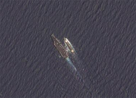
Prince Sultan Air Base was struck shortly afterward, with satellite imagery recorded during 1 March reportedly showing smoke rising from damaged sections of the installation.
American officials later confirmed that one U.S. service member was seriously wounded during the attack and subsequently died from sustained injuries.
The timing created immediate concern because Prince Sultan Air Base remains central to American force projection, missile defence coordination, and regional command activities inside Saudi Arabia.
MizarVision reportedly published similarly detailed imagery covering Naval Support Facility Diego Garcia, highlighting U.S. and British assets positioned across the strategically vital Indian Ocean outpost.
Diego Garcia occupies exceptional strategic importance because it supports long-range bomber deployments, maritime surveillance, logistics operations, and contingency strike planning throughout the Middle East.
The company also reportedly released imagery identifying American F-22 fighter deployments and air-defence positions at Israeli air bases during the same confrontation.
Commercial Geospatial Intelligence Is Compressing the Kill Chain
Military planners increasingly fear that artificial intelligence-enhanced commercial imagery is collapsing the traditional intelligence-to-strike process from days into potentially only several operational minutes.
Historically, hostile forces required lengthy reconnaissance cycles involving multiple intelligence agencies, human analysts, and classified collection systems before missile attacks could be organised.
Commercial geospatial intelligence now allows relatively weaker actors to acquire many of those capabilities without possessing advanced military satellites or expensive intelligence networks.
By combining satellite imagery, machine-learning analysis, and open-source dissemination, companies such as MizarVision are effectively democratising sophisticated battlefield targeting capabilities.
That transformation disproportionately benefits organisations including the IRGC because it reduces longstanding asymmetries between technologically superior militaries and less-resourced regional adversaries.
The distinction between civilian commercial activity and military intelligence is consequently becoming increasingly blurred, complicating deterrence, attribution, and escalation management during regional crises.
American and allied commanders are especially concerned because publicly available datasets can be weaponised rapidly without leaving obvious evidence of direct foreign government involvement.
Such ambiguity potentially enables indirect strategic support for hostile military operations while preserving plausible deniability for states connected politically or economically with participating companies.
The U.S. and Its Allies Are Being Forced Toward New Defences
American officials increasingly believe traditional protective measures including camouflage, hardened shelters, emission control, and static defensive layouts are becoming progressively less effective.
Artificial intelligence systems can reportedly compare time-series imagery, identify subtle deployment patterns, and detect operational anomalies that human analysts might overlook completely.
As a result, U.S. and allied forces are reportedly accelerating efforts toward mobile basing, distributed logistics, deception tactics, inflatable decoys, and rapidly shifting operational footprints.
Those measures are intended to complicate Iranian targeting calculations by creating uncertainty regarding which assets are genuine, where they are located, and when they remain vulnerable.
Washington has also reportedly requested that commercial satellite companies, including Planet Labs, temporarily withhold imagery covering active conflict zones throughout the Middle East.
Australian policymakers have echoed those concerns, with members of Australia’s Select Committee on the Chinese Communist Party describing the emerging surveillance threat as immediate.
Australian officials additionally highlighted MizarVision’s monitoring of HMAS Toowoomba, suggesting that allied naval deployments could also become increasingly exposed through commercial geospatial analysis.
The broader strategic implication is that future conflicts may depend less upon controlling classified intelligence and more upon controlling publicly available commercial information ecosystems.
The controversy ultimately demonstrates that battlefield advantage increasingly belongs to militaries capable of hiding operational patterns faster than artificial intelligence can discover and distribute them.
For Washington, the immediate challenge extends beyond protecting individual bases because the credibility of American regional deterrence depends upon preserving survivable, unpredictable, and operationally resilient force posture.
For Tehran, the alleged exploitation of commercial geospatial intelligence potentially offers an inexpensive method for threatening superior military forces without matching their conventional technological capabilities.
For Beijing, even indirect association with these developments risks intensifying international scrutiny regarding China’s expanding dual-use technology sector and its broader civil-military fusion strategy.