China’s Three Satellites Could Track Every U.S. Warship on Earth — Pentagon Faces End of Naval Stealth
China’s successful tracking of a moving tanker from geosynchronous orbit signals a strategic breakthrough that could allow Beijing to monitor U.S. carrier strike groups, submarines and naval convoys continuously across every ocean.

(DEFENCE SECURITY ASIA) — China’s successful tracking of a moving commercial tanker from geosynchronous orbit has abruptly transformed the military balance in space, potentially giving Beijing the ability to monitor entire U.S. naval formations continuously across every ocean.
The breakthrough carries immediate implications for carrier strike groups, ballistic-missile submarines, amphibious task forces and logistics convoys because only three Chinese satellites could theoretically maintain uninterrupted global maritime surveillance day and night.
For the U.S. Navy, which has long relied upon weather, distance and the gaps between low-orbit reconnaissance satellites to conceal operational movements, the demonstration signals the possible collapse of one of its most important strategic advantages.

As the 340-metre Japanese tanker Towa Maru crossed rough seas near the Spratly Islands, a Chinese geosynchronous synthetic-aperture radar satellite maintained continuous contact from 35,800 kilometres above Earth despite cloud cover, darkness and severe ocean interference.
Lead researcher Hu Yuxin declared that the new processing architecture could isolate weak ship echoes from violent sea clutter at distances previously considered physically impractical, fundamentally overturning assumptions about high-orbit radar reconnaissance.
If fused with other Chinese intelligence networks, including over-the-horizon radars, underwater sensors, drones and long-range anti-ship missiles, the capability could dramatically compress warning times for U.S. naval commanders throughout the Indo-Pacific.
The demonstration is especially consequential because American carrier strike groups approaching Taiwan or the South China Sea could now be detected, tracked and targeted far earlier than previously assumed.
A surveillance architecture requiring only three satellites would also reduce China’s dependence upon vulnerable low-orbit constellations, making its maritime reconnaissance network substantially harder to disrupt during wartime.
The achievement therefore threatens to shift the strategic competition between Washington and Beijing away from merely controlling sea lanes toward controlling the orbital infrastructure that now determines who can see first.
For Pentagon planners, the satellite’s success represents not simply a Chinese technical milestone but the possible emergence of a new battlespace in which concealment at sea may no longer exist.
READ: China’s Jilin-1 Spy Satellite Network Is Watching the U.S.–Iran War in Real Time — Beijing Quietly Harvests American Warfighting Data for Future Indo-Pacific Conflict
Three Satellites Could Create a Permanent Global Maritime Surveillance Grid
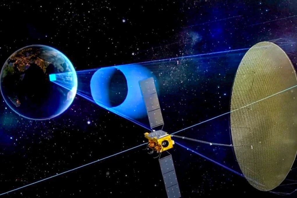
China’s geosynchronous synthetic-aperture radar system represents a radical departure from conventional military reconnaissance because a satellite positioned above the equator can observe the same maritime region continuously instead of briefly passing overhead.
Unlike low-Earth orbit surveillance satellites, which normally operate between 500 and 1,200 kilometres above Earth and revisit targets only intermittently, a geosynchronous platform remains fixed above one location at roughly 35,800 kilometres.
That orbital geometry means three Chinese satellites positioned over the Atlantic, Indian and Pacific Oceans could theoretically create an uninterrupted reconnaissance network covering nearly every major shipping lane and naval operating area.
Such a constellation would give Beijing persistent visibility over U.S. carrier groups leaving Guam, logistics vessels transiting the Philippine Sea and amphibious forces operating near Taiwan or the South China Sea.
The strategic significance is magnified because the United States currently depends largely upon larger constellations of lower-orbit radar satellites requiring hundreds, potentially thousands, of spacecraft for similar persistence.
China’s achievement therefore introduces a far cheaper and more survivable approach to maritime surveillance, allowing Beijing to concentrate resources on a handful of extremely capable platforms rather than vast orbital constellations.
Military planners have long assumed that geosynchronous orbit was unsuitable for tracking moving ships because the radar signal weakens dramatically over such immense distances and becomes overwhelmed by wave reflections.
The Chinese demonstration challenges that assumption directly because the satellite not only detected the Towa Maru but maintained a stable tracking solution while the vessel manoeuvred through difficult weather.
For Indo-Pacific commanders, the result is strategically alarming because future Chinese satellites could watch entire naval formations continuously rather than merely identifying their last known positions.
Precision Sufficient for Missile Targeting Changes the Naval Equation
Chinese researchers reported that the geosynchronous satellite tracked the Towa Maru with an error margin of approximately three kilometres despite the vessel operating amid heavy seas and substantial radar interference.
Other ships within the same surveillance area were reportedly located with errors as low as 1.6 kilometres, producing a level of accuracy previously regarded as unattainable from geosynchronous orbit.
Although such precision is insufficient for a direct missile strike without additional data, it becomes militarily decisive when combined with other Chinese intelligence and targeting systems.
A ship located within several kilometres can be reacquired rapidly by maritime patrol aircraft, drones, over-the-horizon radar or additional satellites operating at lower altitudes and higher resolution.
That layered approach could permit China’s anti-ship ballistic missiles, cruise missiles and long-range naval aviation to receive targeting updates throughout an engagement rather than relying upon stale coordinates.
The operational implications are especially significant for weapons such as China’s DF-21D and DF-26 anti-ship ballistic missiles, both designed specifically to threaten U.S. carrier strike groups.
Persistent tracking from space could also support Chinese long-range bombers carrying anti-ship cruise missiles, naval strike drones and submarines attempting to intercept American forces beyond the First Island Chain.
For the U.S. Navy, the development threatens to erode one of the central assumptions underpinning modern carrier operations, namely that a fleet can reposition quickly enough to outrun enemy targeting networks.
If Beijing can maintain a continuous maritime picture through weather, darkness and electronic disruption, American commanders may increasingly need to operate farther from contested regions, reducing combat effectiveness.
The Breakthrough Was Driven by a New Algorithm, Not Merely a New Satellite
The most important element behind China’s achievement appears not to be the satellite itself but the software architecture developed to process enormous quantities of radar information.
At geosynchronous altitude, the radar return from a ship is extraordinarily weak because the signal must travel almost 72,000 kilometres during transmission and reflection before returning to the spacecraft.
That problem is compounded by the constant motion of waves, weather systems and atmospheric distortion, all of which generate background interference masking the ship’s signature.
Hu Yuxin’s research team reportedly solved the problem by dividing massive radar datasets into smaller parallel-processing tasks capable of being analysed almost simultaneously.
The algorithm then isolates tiny differences between the radar reflections produced by ocean waves and those generated by a moving ship, allowing the vessel’s position to emerge.
Chinese researchers described the technique as comparable to hearing a whispered conversation during a violent storm while standing dozens of kilometres away from the speakers.
The significance extends beyond maritime surveillance because the same computational methods could eventually be applied to tracking aircraft, ground vehicles or missile launchers.
Future Chinese military satellites using artificial intelligence and faster onboard processors could therefore achieve much greater precision, higher refresh rates and broader geographical coverage than today’s prototype.
That possibility suggests the current demonstration may represent only an early proof of concept rather than the final operational form of China’s emerging orbital surveillance architecture.
High-Orbit Satellites Are Much Harder to Destroy Than Existing Reconnaissance Systems
The military value of China’s new surveillance approach is increased further because geosynchronous satellites are substantially more difficult to attack than satellites operating in low-Earth orbit.
Most anti-satellite weapons fielded by the United States, China, Russia and India are designed primarily to strike targets several hundred or several thousand kilometres above Earth.
A geosynchronous satellite positioned 35,800 kilometres away lies far beyond the practical reach of many existing interceptors, greatly complicating efforts to disable the system during conflict.
Even if an adversary possessed a capable anti-satellite missile, the long distances involved would provide China with additional warning time and create difficult targeting challenges.
Geosynchronous satellites also enjoy another advantage because each spacecraft can observe a vast area of ocean in a single image rather than focusing narrowly upon smaller regions.
That wide-area visibility means a Chinese commander could potentially monitor multiple U.S. naval formations simultaneously, including support vessels, replenishment ships and escorting warships.
Because only a few satellites are required, China could harden the system through redundancy, electronic protection and reserve spacecraft launched rapidly after wartime losses.
The cost advantage is also considerable because replacing three sophisticated satellites would almost certainly require fewer resources than rebuilding an entire low-orbit reconnaissance constellation.
For Washington, the development therefore creates a new strategic dilemma because traditional anti-satellite planning may no longer guarantee the rapid destruction of China’s space-based maritime surveillance network.
China’s Space-Based Leap Deepens a Wider Military-Technological Shift
The geosynchronous radar breakthrough reinforces a broader pattern in which China is increasingly achieving military advances that narrow or overturn longstanding American technological advantages.
During the past several years, Beijing has simultaneously accelerated development of hypersonic weapons, sixth-generation fighter aircraft, autonomous combat systems and increasingly sophisticated military satellites.
Chinese strategists appear to be integrating those capabilities into a single reconnaissance-strike architecture designed to locate, track and attack high-value targets across enormous distances.
Within such a system, a geosynchronous radar satellite would serve as the first layer, identifying naval formations before passing coordinates to additional sensors and strike platforms.
That architecture is especially relevant in a potential conflict around Taiwan because U.S. forces would need to travel across thousands of kilometres before entering the battlespace.
Persistent Chinese surveillance could therefore expose American reinforcements long before they reached contested waters, reducing operational surprise and increasing vulnerability to pre-emptive attack.
The United States retains major advantages in carrier aviation, stealth aircraft, undersea warfare and global alliances, yet this latest Chinese advance highlights growing pressure upon those traditional strengths.
American officials will now face difficult choices between investing in larger space constellations, developing better counter-space capabilities or redesigning naval doctrine for an era of permanent observation.
Unless those adjustments occur rapidly, China’s demonstration over the South China Sea may eventually be remembered as the moment when maritime invisibility disappeared and every U.S. warship became permanently exposed.