China’s Jilin-1 Spy Satellite Network Is Watching the U.S.–Iran War in Real Time — Beijing Quietly Harvests American Warfighting Data for Future Indo-Pacific Conflict
China’s Jilin-1 satellite constellation is reportedly monitoring U.S. military operations during the escalating U.S.–Iran conflict, capturing aircraft deployments, missile trajectories, carrier movements and logistics cycles—data that analysts believe could provide the People’s Liberation Army with unprecedented insight into American warfighting doctrine.

(DEFENCE SECURITY ASIA) — The escalation of the U.S.–Iran conflict following coordinated American and Israeli strikes under Operation Epic Fury has unexpectedly transformed the Middle East battlefield into a strategic intelligence laboratory for Beijing, as China’s expansive Jilin-1 Earth-observation satellite constellation systematically records U.S. operational behaviour, creating a data archive that analysts believe could influence People’s Liberation Army (PLA) doctrine for decades.
Evidence emerging from recent imagery releases and analytical reports indicates that the Jilin-1 constellation operated by Chang Guang Satellite Technology Co. (CGST) has been observing key elements of the conflict—including strike patterns, aircraft deployments, missile trajectories, and logistics cycles—turning the unfolding confrontation between Washington and Tehran into a near-real-time dataset of American warfighting tactics.
The strategic stakes of this surveillance effort intensified after U.S. officials, including Deputy National Security Adviser Jon Finer, publicly accused China of enabling Iranian attacks by providing intelligence derived from commercial satellite monitoring, allegations Beijing rejects by arguing that the imagery collected by Chinese firms represents commercial Earth-observation activity rather than military cooperation.
Despite those denials, the density and responsiveness of the Jilin-1 satellite network have created unprecedented observation coverage of U.S. military activity across the Middle East, allowing analysts to reconstruct operational timelines that reveal how American airpower, missile defense, and logistical networks function during high-intensity regional warfare.
This evolving situation has also highlighted a structural shift in global intelligence competition, as the availability of commercial high-resolution satellite imagery allows both state actors and non-state observers to monitor sensitive military deployments once concealed by classified reconnaissance platforms.
For China’s strategic planners, the ongoing U.S.–Iran confrontation therefore offers a rare opportunity to observe American operational tempo, force posture, and logistics architecture, generating insights that could shape future anti-access/area-denial (A2/AD) strategies in potential Indo-Pacific conflict scenarios.
Jilin-1 Constellation Enables Persistent Surveillance of U.S. Combat Operations
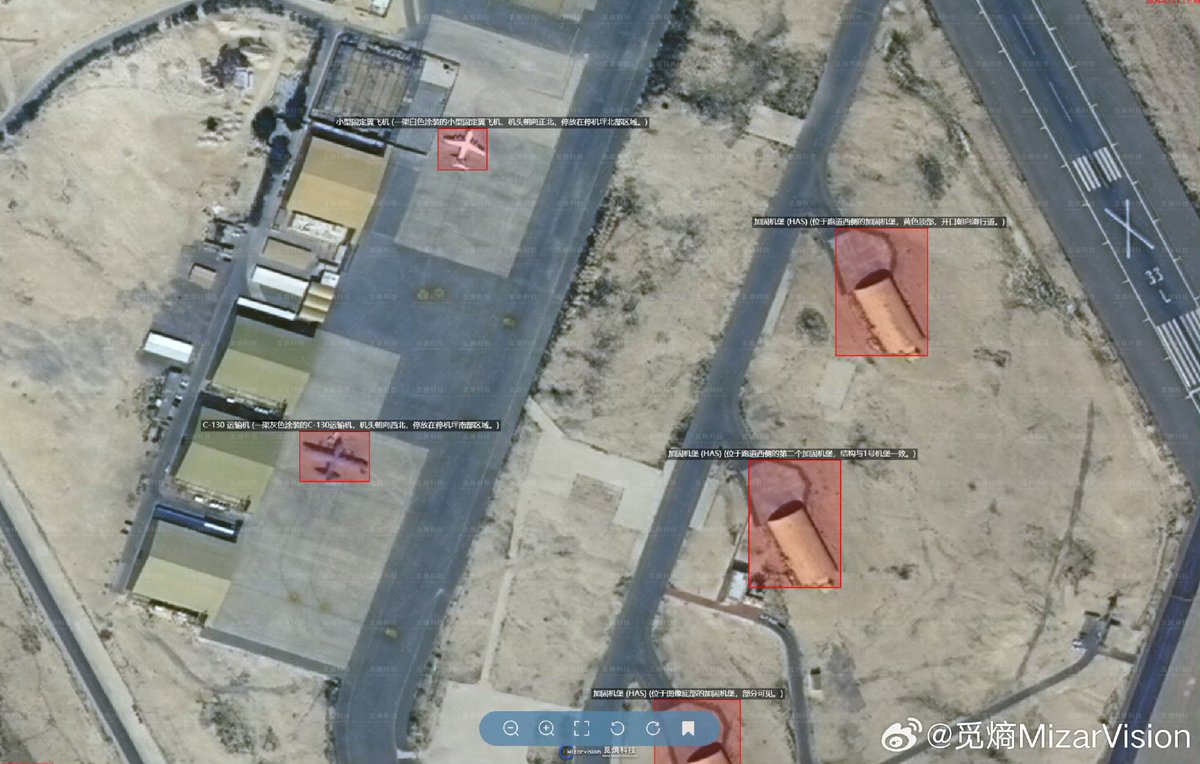
China’s Jilin-1 satellite constellation, operated by Chang Guang Satellite Technology Co., has emerged as a central instrument for observing the evolving U.S.–Iran conflict, enabling near-continuous surveillance of military operations across the Middle East through a network designed specifically for high-frequency Earth observation.
The constellation’s scale allows Chinese analysts to conduct persistent stare monitoring, meaning satellite passes occur frequently enough to reconstruct operational timelines that capture changes in American force posture, aircraft activity, and logistics movements during active military campaigns.
Satellite imagery released by Chinese firms and related analytic platforms has revealed detailed views of U.S. F-22 fighter deployments at airbases such as Ovda in Israel and Al Udeid in Qatar, providing visual confirmation of the distribution of advanced stealth aircraft during the opening phases of the conflict.
Additional imagery has also captured the movements of major U.S. naval assets including the aircraft carrier USS Gerald R. Ford, demonstrating the ability of the Jilin-1 network to monitor maritime force projection in real time as carrier strike groups reposition within the region.
By analysing successive satellite passes over the same locations, Chinese observers can reconstruct patterns of munition loading, aircraft sortie cycles, and ground-support operations, turning what were once isolated intelligence snapshots into a structured dataset describing the mechanics of American expeditionary warfare.
This analytical capability is particularly valuable because it allows the reconstruction of operational tempo, revealing how quickly U.S. forces respond to Iranian missile launches or regional escalation events and how rapidly airpower assets can be repositioned between bases.
Imagery circulated through platforms linked to Chinese satellite companies such as MizarVision has also shown counts of aircraft, missile defence batteries, and other military assets stationed at facilities later targeted by Iranian strikes, suggesting that the monitoring process captures both pre-strike and post-strike operational conditions.
Examples shared through social media platforms have demonstrated the global reach of these satellites, including observation footage from locations such as Atlanta’s airport and the Diego Garcia naval base, reinforcing the notion that Jilin-1 monitoring extends far beyond the Middle East conflict zone.
The strategic consequence of such surveillance lies not merely in the imagery itself but in the cumulative dataset created by repeated observation, which gradually reveals how U.S. forces structure kill chains, logistical supply cycles, and defensive responses during active combat operations.
For Chinese military analysts studying the operational behaviour of the United States, the Jilin-1 constellation effectively converts the U.S.–Iran conflict into a live demonstration of American combat doctrine, operational flexibility, and expeditionary logistics, providing insights that could inform PLA planning for years.

Multi-Layered Chinese Surveillance Network Expands Battlefield Visibility
While the Jilin-1 satellite constellation forms the most visible component of China’s observation architecture during the U.S.–Iran conflict, analysts note that it operates within a broader network of Chinese intelligence-gathering systems spanning orbital, maritime, and navigation platforms.
Among these supporting systems are China’s Yaogan satellite series, a group of military reconnaissance platforms equipped with radar imaging and signals intelligence capabilities designed to collect electronic emissions and track military activities across vast geographic areas.
The combination of Yaogan satellites and Jilin-1 optical imagery allows Chinese analysts to correlate signals intelligence with visual reconnaissance, producing a layered understanding of operational patterns such as radar activation cycles, missile launches, and aircraft deployments.
Another key element of this surveillance ecosystem is the BeiDou satellite navigation system, which Iran has reportedly adopted as an alternative to U.S.-controlled GPS signals in order to enhance the resilience of its missile guidance systems against potential American electronic warfare interference.
The integration of BeiDou navigation with Iranian missile operations demonstrates how satellite infrastructure can influence battlefield dynamics by providing alternative positioning and navigation capabilities in environments where traditional navigation signals may be disrupted.
Beyond orbital assets, Chinese surveillance activity also extends to sea-based platforms, including the Liaowang-1 reconnaissance ship operating in the Gulf of Oman, which is capable of tracking missile launches and satellite trajectories while relaying observational data back to Chinese analysts.
The presence of such maritime reconnaissance vessels complements satellite coverage by providing additional tracking capability during missile launches or other events where orbital observation windows may be limited by satellite positioning.
This multi-layered observation network therefore creates a surveillance architecture capable of capturing missile trajectories, aircraft operations, and logistical movements from multiple vantage points, significantly enhancing China’s ability to reconstruct the operational environment of the U.S.–Iran conflict.
Historical precedents demonstrate that similar observation patterns have already occurred in regional conflicts, including monitoring of Houthi military operations in 2025, where satellite imagery was reportedly used to analyse targeting patterns and battlefield developments.
The expansion of Chinese surveillance capabilities has even extended into orbital monitoring itself, illustrated by a September 2025 incident in which a Jilin-1 satellite captured imagery of a U.S. WorldView Legion reconnaissance satellite, signalling the emergence of a competitive dynamic within space-based intelligence operations.
Allegations of Intelligence Sharing Between China and Iran
A major source of controversy surrounding the Jilin-1 monitoring effort concerns claims that satellite data collected by Chinese systems is being shared with Iranian military forces, potentially enhancing Tehran’s ability to track U.S. deployments and plan retaliatory operations.
Multiple reports suggest that imagery and analytical data derived from Jilin-1 and Yaogan satellites may provide Iran’s Islamic Revolutionary Guard Corps with coordinates and situational awareness regarding U.S. naval vessels, military bases, and carrier strike groups operating in the region.
Such intelligence would allow Iranian planners to monitor changes in U.S. air defense deployments, aircraft groupings, and naval movements, potentially reducing uncertainty about American operational intentions during periods of escalating confrontation.
If accurate, the sharing of such information could significantly alter the strategic balance of the conflict by making U.S. force movements more transparent to Iranian commanders, thereby complicating Washington’s ability to achieve operational surprise.
Satellite imagery has also reportedly been used to assist Iran-aligned groups such as the Houthi movement, highlighting the potential for commercial Earth-observation data to influence conflicts beyond traditional state-to-state military engagements.
Evidence cited by analysts includes U.S. interceptions in 2025 of Chinese communications equipment linked to Houthi forces, suggesting the possibility of technological collaboration between Chinese systems and Iranian proxy networks.
The intelligence-sharing allegations have gained additional significance because Iran reportedly accesses satellite imagery not only from China but also from Russia’s Kanopus-V Earth-observation satellites, creating a hybrid intelligence architecture that blends multiple international sources.
Despite the availability of Russian imagery feeds, analysts suggest that Chinese systems dominate in terms of high-resolution optical imagery and rapid revisit times, making them particularly valuable for tracking rapidly evolving military situations.
The United States has responded to these developments by accusing China of indirectly enabling Iranian military actions through the provision of satellite intelligence, a claim strongly rejected by Beijing, which maintains that the imagery is generated through commercial observation platforms rather than military intelligence sharing.
This divergence between accusations and denials underscores the complexity of distinguishing between commercial satellite activity and strategic intelligence collaboration in an era where high-resolution Earth observation technology is increasingly available to multiple actors.
Strategic Intelligence Value for China’s Military Research
Beyond the immediate tactical implications of the U.S.–Iran conflict, analysts argue that the true strategic significance of China’s satellite monitoring lies in the long-term intelligence value of the operational data collected during the war.
By systematically observing U.S. combat operations, the Jilin-1 constellation allows Chinese analysts to compile what some experts describe as a “live encyclopedia” of American military tactics, encompassing everything from aircraft sortie cycles to logistical resupply patterns.
Such a dataset could provide invaluable insights into the structure of U.S. kill chains, command-and-control processes, and operational decision timelines, revealing the internal dynamics of American expeditionary warfare during real conflict conditions.
Over time, these observations could contribute to the development of new People’s Liberation Army operational doctrines, particularly those focused on countering U.S. power projection capabilities in regions such as the Western Pacific and the South China Sea.
The information derived from satellite monitoring could also enhance Chinese understanding of how the United States manages multi-domain warfare environments, integrating airpower, missile defense systems, naval deployments, and logistical infrastructure into coordinated military campaigns.
For planners within China’s defense establishment, the U.S.–Iran conflict therefore represents an unexpected opportunity to study the performance of American military systems under operational stress without engaging in direct confrontation.
Analysts believe the resulting intelligence archive could influence Chinese strategic planning for decades, informing the design of anti-access/area-denial (A2/AD) strategies aimed at limiting U.S. operational freedom in potential future conflicts.
The ability to monitor U.S. responses to Iranian missile strikes and regional escalation events also provides insights into how American forces adjust force posture and defensive deployments in reaction to emerging threats.
These observations could prove particularly valuable in modelling potential conflict scenarios involving U.S. forces in the Indo-Pacific, where China seeks to understand the deployment timelines and reaction speeds of American expeditionary forces.
Consequently, the strategic value of China’s satellite monitoring effort lies not merely in real-time intelligence but in the long-term analytical framework it creates for understanding the operational behaviour of the world’s most powerful military.
“Democratization of Intelligence” and the Erosion of Battlefield Secrecy
The use of commercial satellite constellations such as Jilin-1 during the U.S.–Iran conflict reflects a broader transformation in global intelligence dynamics often described by analysts as the “democratization of intelligence.”
Advances in satellite technology have dramatically increased the availability of high-resolution imagery, enabling commercial companies to capture detailed views of military installations that were once observable only through classified government reconnaissance platforms.
This technological shift has eroded the traditional secrecy surrounding military deployments, as imagery collected by private firms can now circulate widely through open-source intelligence networks and social media platforms.
In the context of the U.S.–Iran conflict, the dissemination of satellite imagery showing aircraft deployments, missile defenses, and naval movements has allowed independent analysts to reconstruct elements of the battlefield environment in near real time.
Posts circulating on platforms such as X (formerly Twitter) have amplified the reach of this imagery, transforming satellite observations into widely accessible datasets that can influence public understanding of military developments.
This open-source intelligence ecosystem creates both opportunities and risks, as the availability of satellite imagery can enhance transparency while simultaneously exposing operational vulnerabilities.
For the United States, the widespread availability of satellite monitoring means that military planners must assume that force movements and logistical activities may be visible to adversaries and observers alike, reducing the effectiveness of traditional concealment strategies.
The implications extend beyond the Middle East conflict itself, as similar monitoring capabilities could be applied to future crises in other regions, including the Indo-Pacific, where Chinese and American military forces operate in close proximity.
Analysts therefore argue that the proliferation of commercial satellite constellations is reshaping the strategic environment by making it increasingly difficult for military forces to operate without being observed from orbit.
As this technological transformation accelerates, the challenge facing military planners worldwide will be adapting operational doctrines to a world where battlefield transparency from space has become an unavoidable reality.
U.S. Countermeasures and the Limits of Orbital Surveillance
Faced with the growing visibility of its military operations from space, the United States has begun adapting its force posture and operational behaviour to mitigate the intelligence advantages created by satellite surveillance.
One approach involves the dispersal of military assets across multiple bases, reducing the concentration of aircraft and equipment that could otherwise provide clear indicators of operational readiness.
Another strategy involves the use of decoys and deceptive deployment patterns, designed to complicate the interpretation of satellite imagery by creating uncertainty about the true distribution of military assets.
Despite these countermeasures, analysts acknowledge that orbital observation remains a significant challenge because satellite constellations with high revisit rates can capture frequent images that reveal gradual changes in operational activity.
The persistence of satellite coverage means that even small logistical movements—such as the arrival of additional aircraft or the repositioning of missile defense systems—can be detected over time through comparative imagery analysis.
Sanctions imposed by the United States against Chang Guang Satellite Technology Co., the operator of the Jilin-1 constellation, represent another attempt to limit the strategic impact of Chinese satellite monitoring.
However, enforcement of such sanctions has proven difficult due to the commercial nature of the satellite imagery industry and the global distribution of Earth-observation data.
This limitation highlights the structural challenge faced by governments attempting to regulate technologies that are increasingly embedded within commercial markets and international data networks.
As a result, the emergence of commercial satellite constellations has created a strategic environment in which space-based observation is no longer controlled exclusively by national intelligence agencies.
The ongoing monitoring of the U.S.–Iran conflict by China’s Jilin-1 constellation therefore illustrates a broader transformation in global security dynamics, where the intersection of commercial technology and military operations is reshaping the balance between secrecy, surveillance, and strategic intelligence.