Chinese AI Startup Made US F-22 Stealth Jets Visible — Then Iranian Strikes Hit Revealed Targets During Operation Epic Fury
A Chinese AI geospatial startup used commercial satellite imagery and automated annotation to expose US F-22 Raptors, THAAD batteries and allied force posture across the Middle East, raising urgent questions about stealth survivability, logistics vulnerability and the future of operational secrecy in modern warfare.

(DEFENCE SECURITY ASIA) — The launch of Operation Epic Fury in late February 2026 coincided with MizarVision releasing AI-annotated satellite imagery exposing US F-22 Raptors at Israe’s Ovda Air Base and allied defenses in Jordan and Saudi Arabia, creating strategic urgency by compromising force postures and logistics footprints and forcing defence planners to reassess operational secrecy with global consequences for power projection.
Analysts described MizarVision’s activities as de facto proxy intelligence in which US-origin commercial data processed by Chinese AI appeared to align with Iranian targeting sequences after the imagery releases, intensifying concern over the erosion of stealth advantages and visible logistics movements across the Middle East.
The development signalled a shift toward ubiquitous surveillance in modern warfare, where dispersed carrier strike groups, air defense batteries and forward air bases could be identified rapidly by AI-assisted analysis, altering deterrence dynamics with implications extending to the Taiwan Strait and South China Sea where similar exposure could affect operational security.
The Small Chinese Startup MizarVision Achieves Massive Geospatial Intelligence Impact
The operational structure of Mishang Technology Hangzhou Co., Ltd., known as MizarVision, with fewer than two hundred personnel and technical expertise linked to Huawei and Chinese research institutions, enabled the purchase of commercial imagery from Maxar and Planet Labs and the AI-driven classification that identified eleven F-22 Raptors at Ovda Air Base, exposing reinforcement logistics footprints before Operation Epic Fury.
The company’s positioning as a business-to-business geospatial analysis platform allowed it to publish annotated maps on social media identifying Patriot and THAAD batteries in Jordan and Saudi Arabia, revealing defensive force posture locations that could influence targeting considerations and complicate the logistical sustainment planning of allied air defense networks during the escalating crisis.
By increasing posting frequency around 20 February 2026, days before the launch of Operation Epic Fury on 28 February, MizarVision released imagery of carrier strike groups in the Arabian Sea that exposed naval logistics patterns and altered perceptions of strategic signalling among regional actors observing the buildup of US and allied forces.
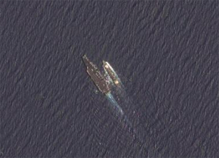
Follow-up imagery showing damage at Al Udeid in Qatar after strikes on 3–4 March demonstrated change-detection capabilities that tracked degradation of US assets over time, illustrating how commercial GEOINT analysis could provide insight into the resilience of forward force posture during ongoing operations.
Annotated imagery identifying aircraft deployments at Ali Al Salem in Kuwait made visible the scale of US sustainment activity supporting Operation Epic Fury, forcing analysts to reconsider assumptions that forward logistics chains could remain concealed during high-intensity conflict conditions.
Public dissemination through Weibo and later X of tanker aircraft and AWACS positions across Bahrain and the UAE transformed commercially purchased satellite images into widely accessible intelligence products, eroding concealment of allied force posture and complicating planning for maintaining operational tempo under Iranian missile threat.
The lean structure of MizarVision, founded in 2021 without owning satellites, allowed rapid processing of imagery showing deployments in Qatar and Jordan, exposing the extent of US air defense logistics footprint and demonstrating how small analytical teams could reveal operational details previously hidden behind classified channels.
The absence of satellite ownership yet ability to reveal precise asset locations using purchased Western imagery illustrated how the company’s model democratized geospatial intelligence, raising questions among defence observers about the viability of traditional secrecy for force posture during active conflict.
READ: Chinese Satellite Leak Exposes 11 U.S. F-22 Raptors at Israel’s Ovda Base
Proprietary AI Technology Accelerates Automated Detection and Annotation
MizarVision’s proprietary AI enabled automated object detection capable of distinguishing F-22 aircraft from other fighters within hours of image acquisition, accelerating identification of stealth deployments at Ovda Air Base and reducing the time window in which sensitive logistics movements could remain undisclosed.
Change-detection algorithms tracked the arrival and repositioning of Patriot and THAAD batteries in Jordan and Saudi Arabia across successive satellite passes, allowing rapid annotation that exposed defensive configurations and affected the perceived readiness of allied air defense networks during Iranian retaliation planning.
The speed of AI-assisted labeling for carrier strike group movements in the Arabian Sea turned commercial imagery into near-real-time situational awareness, undermining assumptions that naval dispersal alone could preserve operational concealment in contested maritime environments.
Automated annotation of damage at Al Udeid after the March 3–4 strikes provided visual confirmation of strike effects on US assets, altering assessments of forward base resilience and highlighting how open-source GEOINT could influence perceptions of force posture sustainability.
Classification of aircraft at Ali Al Salem in Kuwait enabled MizarVision to publish counts and positions shortly after imagery acquisition, revealing the scale of US deployment and affecting how reinforcement logistics were interpreted by observers monitoring the conflict.
Publication of AI-processed imagery showing AWACS and tanker aircraft across Bahrain and the UAE accelerated the availability of ISR-like information to the public, demonstrating how commercial analysis could expose aerial sustainment patterns critical to maintaining combat operations.
Integration of object detection with change analysis allowed MizarVision to track deployments in Qatar and Jordan over short intervals, exposing the full logistics footprint of allied air defenses and forcing reconsideration of how dispersal tactics could remain effective under constant observation.
The ability to perform large-scale processing without costly satellite infrastructure enabled the startup to annotate imagery across multiple sites simultaneously, stripping away layers of concealment from force posture and revealing how rapidly commercial GEOINT could influence operational awareness.
Temporal Correlations Between Imagery Releases and Iranian Strikes
Imagery posted between 24 and 27 February showing F-22 Raptors at Ovda Air Base preceded Iranian retaliatory strikes on regional US and Israeli assets, creating a temporal correlation that raised questions among analysts about how publicly visible force posture might affect targeting decisions even without confirmed coordination.
Annotated images of Patriot and THAAD batteries in Jordan and Saudi Arabia appeared before missile attacks on defensive positions in the region, suggesting that the exposure of air defense logistics footprints could reduce uncertainty for any actor planning strikes, although no direct evidence links the imagery to Iranian targeting.
Carrier strike group positions in the Arabian Sea released shortly before retaliatory actions created another sequence in which publicly available GEOINT appeared to coincide with operational events, prompting reassessment of how visible naval deployments influence strategic signalling during crises.
Imagery highlighting Al Udeid Air Base was followed by ballistic missile strikes on 3–4 March, some of which penetrated defenses, reinforcing concerns that large operational hubs cannot easily conceal their logistics footprint once high-resolution imagery is analysed and distributed widely.
Annotated maps of Ali Al Salem in Kuwait circulated online during the same period as Iranian drone and missile waves targeting regional bases, underscoring the risk that exposure of forward basing patterns can affect perceptions of vulnerability even if attackers possess independent intelligence sources.
Posts showing AWACS and tanker aircraft positions across Bahrain and the UAE appeared in the days before strikes on support facilities, illustrating how visibility of aerial sustainment assets can alter the perceived stability of coalition force posture during active conflict.
The ramp-up of imagery releases covering deployments in Jordan and Qatar before retaliatory strikes established patterns that analysts examined cautiously, noting that correlation does not confirm causation but still exposes gaps in assumptions about maintaining secrecy in the era of commercial GEOINT.
Follow-up damage-assessment imagery published after the strikes reinforced the sense of continuity between observation and battlefield events, highlighting how open-source analysis can track the entire cycle of deployment, attack and assessment without access to classified intelligence.
Democratized GEOINT Erodes Stealth and Dispersal Advantages
The availability of AI-processed commercial imagery showing F-22 deployments at Ovda demonstrated that stealth technology does not prevent ground-based detection by satellites, reducing the effectiveness of concealment strategies that rely on controlling electronic emissions rather than visual observation.
Public identification of Patriot and THAAD systems in Jordan and Saudi Arabia removed the secrecy that once protected defensive networks, forcing planners to consider that logistics footprints for air defense cannot easily be hidden when high-resolution imagery is commercially accessible.
Carrier strike group tracking through repeated satellite passes showed how naval mobility alone cannot guarantee concealment when AI analysis links multiple observations into a coherent operational picture of fleet movements.
Exposure of Al Udeid as a major hub for US air operations illustrated how large air bases generate visible infrastructure signatures that reveal the scale of operations even without classified intelligence, affecting assessments of force posture resilience.
Identification of deployments at Ali Al Salem showed that forward logistics required for rapid reinforcement can be mapped through open-source imagery, complicating assumptions that such movements can occur without attracting attention.
Annotation of AWACS and tanker activity across Bahrain and the UAE demonstrated that aerial support networks are also visible, meaning sustainment operations essential to maintaining air campaigns may become predictable once imagery is analysed continuously.
Open-source dissemination of imagery covering Qatar and Jordan illustrated how commercial GEOINT removes barriers to intelligence access, allowing any observer to monitor the buildup of forces without operating satellites.
The precedent established during Operation Epic Fury suggested that affordable AI-driven analysis could allow smaller states or non-state actors to build effective ISR awareness, challenging the traditional dominance of major powers in intelligence collection.
Regulation Debate After Open-Source GEOINT Becomes Strategic Factor
The reduction in aggressive posting after the initial strikes and the suspension of some high-resolution releases over the Middle East by a commercial provider in early March highlighted growing calls for regulation of imagery distribution in conflict zones.
The transformation of open-source GEOINT into a strategic factor during Operation Epic Fury led analysts to question whether unrestricted sale of commercial imagery could unintentionally influence ongoing military operations.
Debate intensified over the fact that Western companies provide the raw imagery while foreign analytical platforms can process and publish it, creating vulnerabilities in allied force posture that current export rules do not fully address.
The precedent of carrier groups and air defense systems being publicly identified before strikes raised concerns about whether existing controls on geospatial data are sufficient for modern high-intensity conflict.
Imagery showing damage at Al Udeid and Ali Al Salem increased pressure for new restrictions, as the ability to track both deployments and strike effects in public space blurred the line between civilian analysis and operational intelligence.
The evolution of commercial GEOINT into widely shareable content demonstrated that information once limited to classified channels can now circulate globally within minutes, forcing reconsideration of how secrecy can be maintained.
Uncertainty remains about whether Iranian forces used the imagery directly, but the sequence of events highlighted the risk that open data flows may still influence decision-making during active conflict.
The precedent set by MizarVision during Operation Epic Fury showed that the age of hidden force posture is ending, and that future warfare will occur under conditions of constant observation where managing visibility becomes as important as deploying combat power.