Indonesia’s ‘Silent Ocean Shield’: KRI Canopus-936 Dramatically Expands Jakarta’s Underwater Surveillance Amid South China Sea Tensions
Indonesia’s first submarine rescue-capable vessel strengthens underwater intelligence, seabed mapping, and submarine survivability as Indo-Pacific naval competition increasingly shifts beneath the ocean surface.

(DEFENCE SECURITY ASIA) — Indonesia’s decision to operationally induct KRI Canopus-936 has elevated Jakarta’s underwater warfare support and maritime intelligence posture at a moment when strategic competition across the Indo-Pacific increasingly revolves around seabed surveillance, submarine survivability, and control of critical maritime approaches.
The arrival of Indonesia’s first submarine rescue-capable vessel at the Kolinlamil pier in Tanjung Priok carries geopolitical significance far beyond humanitarian rescue operations because it substantially expands the Indonesian Navy’s ability to monitor, map, and secure underwater domains stretching across one of the world’s most strategically contested maritime regions.
Navy Chief of Staff Admiral Muhammad Ali’s declaration that KRI Canopus-936 represents “our first submarine rescue vessel” immediately transformed the platform from a conventional hydro-oceanographic ship into a strategic maritime infrastructure asset capable of reshaping Indonesia’s operational confidence following the catastrophic 2021 sinking of KRI Nanggala-402.
The official reception ceremony attended by Deputy Defense Minister Donny Ermawan Taufanto, TNI Commander General Agus Subiyanto, and senior Indonesian Navy leadership underscored the vessel’s strategic importance within Jakarta’s broader maritime modernization and underwater domain awareness architecture.
The 57-day voyage from Germany to Indonesia under “Operasi Dhruva Samudra-26,” covering approximately 12,798.5 nautical miles, simultaneously demonstrated the vessel’s endurance profile and Indonesia’s growing ambition to operate advanced naval support platforms across extended maritime theaters.
The platform’s induction also reflects Indonesia’s accelerating determination to reduce long-term dependence on foreign maritime intelligence, hydrographic mapping, and underwater operational support capabilities as regional maritime tensions continue intensifying across the South China Sea and North Natuna Sea.
Admiral Muhammad Ali’s confirmation that a dedicated Submarine Rescue Vehicle built in England is scheduled for delivery around 2027 further indicates that KRI Canopus-936 represents only the first phase of a much larger Indonesian underwater rescue and submarine support modernization ecosystem.
The vessel’s combination of deep-sea survey capability, autonomous underwater systems integration, and future submarine rescue functionality effectively provides Indonesia with a dual-use strategic platform capable of supporting both peacetime maritime governance and high-risk underwater contingency operations across contested regional waters.
KRI Canopus-936 also strengthens Indonesia’s ability to generate sovereign underwater intelligence products independently, an increasingly critical strategic requirement as major Indo-Pacific naval powers intensify submarine deployments, seabed mapping missions, and underwater infrastructure competition throughout the broader South China Sea maritime theater.
The operational deployment of the vessel under Pushidrosal further signals Jakarta’s recognition that future maritime deterrence in Southeast Asia will depend not only on visible combat assets, but equally on persistent underwater awareness, seabed dominance, and resilient submarine rescue infrastructure capable of sustaining prolonged naval operations.
READ: Indonesia Deploys Turkish ANKA Drones at Malacca Strait, Triggering New Indo-Pacific Surveillance Power Shift Against Rising South China Sea Tensions
Indonesia’s First Dedicated Submarine Rescue-Capable Platform
KRI Canopus-936 emerged from a strategic industrial collaboration between German shipbuilder Abeking & Rasmussen and Indonesian shipyard PT Palindo Marine, creating a defense-industrial arrangement designed to combine advanced European maritime systems integration with Indonesia’s expanding domestic naval construction ambitions.
The vessel’s hull construction in Batam before transfer to Germany for final outfitting, systems integration, and sea trials demonstrated Jakarta’s growing emphasis on defense technology transfer and industrial offsets rather than reliance on complete foreign-built naval procurement programs.
Indonesia’s requirement that approximately 60 percent of the platform incorporate local content reflected broader national defense self-reliance policies intended to gradually strengthen indigenous naval engineering, sustainment, and maritime systems integration capabilities.
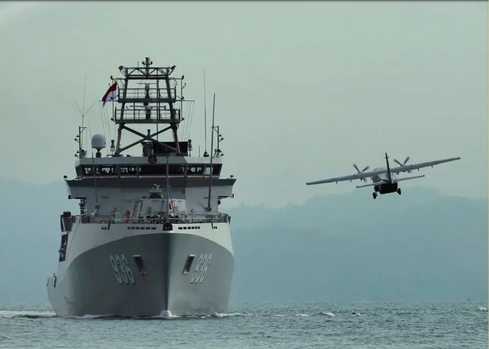
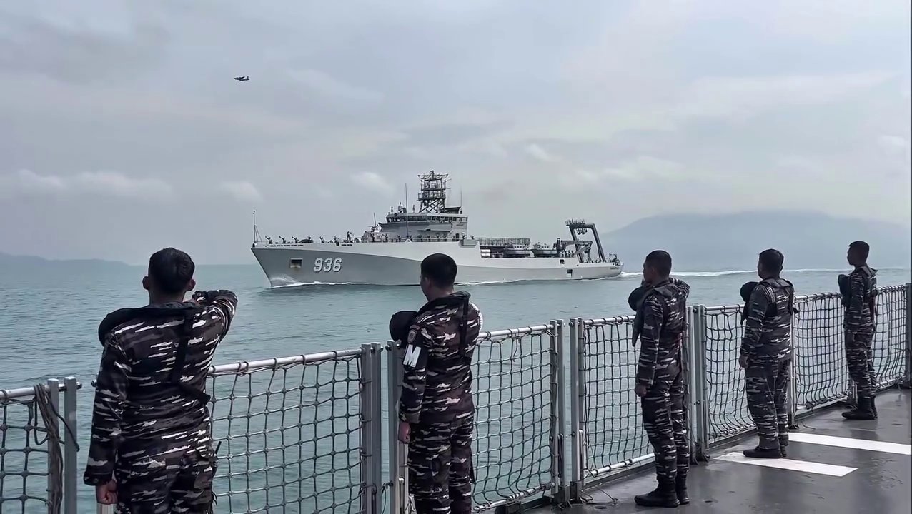
Commissioned on February 12, 2026, at the Abeking & Rasmussen shipyard in Lemwerder during a ceremony led by Vice Admiral Erwin S. Aldedharma, the vessel immediately became the largest survey ship ever operated by the Indonesian Navy.
The replacement of the aging KRI Dewa Kembar (932) with KRI Canopus-936 significantly expands Indonesia’s hydrographic and underwater operational reach because the new vessel possesses far greater endurance, payload flexibility, and autonomous underwater systems integration capacity.
With an overall length of 105 meters, beam measuring approximately 16 to 17.4 meters, and displacement reaching roughly 3,400 tonnes, the vessel occupies a capability category considerably larger than conventional regional hydrographic survey platforms.
Its endurance capability of 60 days at sea, combined with approximately 200 tonnes of additional payload capacity for submarine rescue modules and future rescue vehicle operations, substantially enhances Indonesia’s ability to sustain prolonged underwater search-and-rescue missions across remote maritime sectors.
The vessel’s helicopter flight deck capable of supporting aircraft up to 12 tonnes maximum takeoff weight significantly expands operational flexibility by enabling aerial logistics support, casualty evacuation, maritime surveillance coordination, and rapid deployment of rescue personnel during emergency contingencies.
Although lightly armed with a 20 mm cannon and 12.7 mm machine guns, the platform’s true strategic value lies not in kinetic combat operations but in enabling underwater domain control, seabed intelligence gathering, and maritime operational persistence.
Its integration under the Indonesian Navy Hydro-Oceanographic Center, or Pushidrosal, places the vessel at the center of Jakarta’s long-term maritime intelligence architecture rather than merely positioning it as a limited-purpose rescue support platform.
Underwater Surveillance and Seabed Intelligence Expansion
KRI Canopus-936 dramatically strengthens Indonesia’s maritime domain awareness architecture because it can conduct hydrographic, oceanographic, geophysical, and meteorological surveys from shallow littoral waters to depths reaching approximately 11,000 meters.
This capability substantially improves Jakarta’s understanding of underwater terrain, seabed structures, submarine operating corridors, and maritime choke points across Indonesia’s sprawling archipelagic environment and Exclusive Economic Zone.
The vessel’s integration of Autonomous Underwater Vehicles, Remotely Operated Vehicles, Autonomous Surface Vehicles, and Unmanned Aerial Vehicles reflects a modern multidomain maritime intelligence approach increasingly adopted by advanced naval powers operating in contested maritime environments.
Its Norwegian-built Argus Mariner XL Remotely Operated Vehicle, weighing approximately 1.5 tonnes and operable to depths of 6,000 meters, significantly enhances Indonesia’s ability to inspect seabed infrastructure, recover underwater objects, and conduct deep-water reconnaissance operations.
The platform’s Hydrographic Survey Launcher and advanced seabed mapping systems provide Indonesia with increasingly independent maritime charting capabilities that reduce dependence on foreign hydrographic databases and externally supplied maritime intelligence products.
Detailed underwater mapping capabilities also improve submarine route planning, navigational safety, and underwater maneuverability for Indonesia’s growing submarine fleet operating across narrow straits, shallow archipelagic channels, and strategically sensitive maritime corridors.
The vessel’s sea mine detection capability carries additional military significance because maritime mines remain among the most cost-effective anti-access and area-denial tools capable of disrupting commercial shipping and naval mobility throughout Southeast Asian waters.
Its ability to detect distress signals from sunken submarines or aircraft directly addresses one of the Indonesian Navy’s most painful operational vulnerabilities exposed during the 2021 KRI Nanggala disaster, which killed 53 submariners after the vessel sank near Bali.
By improving underwater search-and-rescue response timelines and operational coordination, KRI Canopus-936 may enable the Indonesian Navy to operate submarines with greater strategic confidence and higher deployment frequency across increasingly contested maritime theaters.
The platform’s intelligence-gathering and maritime patrol support functions also strengthen Indonesia’s ability to monitor suspicious underwater activity, foreign naval operations, and gray-zone maritime behavior without requiring overt force escalation.
Strategic Lessons from the KRI Nanggala Disaster
The destruction of KRI Nanggala-402 in 2021 fundamentally reshaped Indonesian strategic thinking regarding submarine safety, underwater rescue preparedness, and operational survivability within the country’s expanding submarine force structure.
Indonesia’s inability at the time to independently conduct sophisticated underwater rescue operations exposed major operational gaps within Southeast Asia’s submarine support ecosystem despite Jakarta’s ambition to become a major maritime power.
KRI Canopus-936 therefore represents a direct institutional response to lessons derived from the Nanggala tragedy rather than merely serving as a routine naval modernization acquisition.
The planned integration of a dedicated Submarine Rescue Vehicle from England around 2027 indicates that Indonesia intends to eventually establish a credible indigenous underwater rescue capability capable of supporting deep-submergence evacuation missions.
Once operationally paired with the future rescue submersible, KRI Canopus-936 would effectively function as a mothership and command-support node for complex submarine rescue operations across Indonesia’s enormous maritime territory.
This future capability becomes increasingly important because Indonesia continues pursuing submarine force modernization involving Russian-origin Kilo-class submarines and planned acquisition pathways linked to French Scorpene-class platforms.
As Indonesia’s submarine fleet expands, the strategic requirement for credible rescue infrastructure correspondingly increases because operational tempo and underwater deployment frequency inevitably elevate peacetime accident risks and wartime survivability pressures.
The vessel’s 93-member crew underwent seven months of specialized hydrographic and operational training in Germany, France, and Indonesia, reflecting the technical complexity associated with advanced underwater survey and rescue-support operations.
Indonesia’s existing hydrographic education infrastructure simultaneously indicates that Jakarta intends to gradually institutionalize advanced underwater survey expertise domestically rather than permanently depending on foreign technical personnel.
The operationalization of KRI Canopus-936 therefore represents both a capability enhancement and a psychological restoration effort designed to rebuild confidence within Indonesia’s submarine community following one of the country’s deadliest naval disasters.
South China Sea and North Natuna Sea Implications
KRI Canopus-936 arrives as Indonesia faces increasingly complex maritime security pressures in the North Natuna Sea, where Jakarta’s Exclusive Economic Zone overlaps with expansive Chinese maritime claims.
Enhanced underwater mapping and surveillance capabilities provide Indonesia with stronger situational awareness regarding foreign vessel movements, seabed activities, and underwater operational patterns within strategically sensitive maritime sectors.
The platform’s ability to independently collect hydrographic and oceanographic data also strengthens Indonesia’s legal and operational position under UNCLOS by improving evidentiary support for maritime enforcement and sovereign rights assertions.
Rather than responding through overt military confrontation, Jakarta appears to be strengthening long-term maritime persistence and underwater monitoring capabilities consistent with its traditional “free and active” foreign policy doctrine.
This approach allows Indonesia to reinforce sovereignty claims and maritime control without directly aligning with major-power confrontation dynamics dominating broader United States-China strategic rivalry across the Indo-Pacific.
The vessel’s underwater surveillance functions also carry implications for anti-submarine warfare preparedness because detailed seabed mapping significantly improves understanding of acoustic conditions, underwater concealment zones, and submarine operating environments.
Its maritime intelligence functions potentially enhance Indonesia’s capacity to monitor gray-zone operations involving maritime militia activity, unauthorized seabed exploitation, and suspicious underwater infrastructure activity near sensitive maritime approaches.
The ship’s operational endurance profile allows prolonged deployments across remote sectors of Indonesia’s Exclusive Economic Zone, substantially improving maritime persistence within regions traditionally difficult to continuously monitor using conventional patrol assets alone.
Because underwater domain awareness increasingly represents a critical component of modern naval competition, KRI Canopus-936 quietly strengthens Indonesia’s deterrence posture without requiring visible offensive combat force expansion.
The vessel therefore embodies Jakarta’s preference for strategic autonomy, maritime resilience, and sovereign capability development rather than overt militarization despite intensifying regional geopolitical competition.
READ: Strait of Malacca Under Pressure: US–Indonesia Defense Pact Sparks Fears of New Global Oil Chokepoint Crisis Targeting China
Maritime Diplomacy and Indonesia’s Expanding Naval Influence
KRI Canopus-936’s delivery voyage involving port calls in Cape Town and Lagos demonstrated Indonesia’s intention to position itself as an increasingly active maritime stakeholder extending beyond Southeast Asian waters.
These diplomatic port engagements supported broader South-South cooperation initiatives and reinforced Indonesia’s participation within Indian Ocean maritime connectivity and security frameworks including IORA-related cooperation mechanisms.
The vessel’s hydrographic and environmental monitoring functions potentially create opportunities for future multinational maritime data-sharing partnerships involving disaster response, navigational safety, and regional maritime security coordination.
Because advanced hydrographic capabilities remain limited among developing maritime states, Indonesia may eventually leverage KRI Canopus-936 as a platform for regional training cooperation and maritime technical diplomacy.
The German collaboration underpinning the platform simultaneously reflects Jakarta’s deliberate strategy of diversifying defense-industrial relationships rather than becoming excessively dependent on any single major military supplier.
Future British involvement through the planned Submarine Rescue Vehicle acquisition further expands Indonesia’s network of technologically advanced maritime defense partnerships while preserving strategic flexibility.
Indonesia’s emphasis on maritime data sovereignty additionally carries significant geopolitical implications because control over seabed intelligence increasingly influences economic security, resource management, and naval operational planning.
The vessel’s ability to support environmental protection and disaster-response missions also strengthens Indonesia’s soft-power maritime profile by enabling humanitarian and scientific operations alongside traditional military-support activities.
Although KRI Canopus-936 is not an offensive combat platform, its cumulative impact on underwater domain control, maritime intelligence autonomy, and submarine operational confidence substantially elevates Indonesia’s long-term strategic maritime position.
As Indo-Pacific competition increasingly extends beneath the ocean surface into underwater infrastructure, seabed intelligence, and submarine survivability, the quiet arrival of KRI Canopus-936 may ultimately prove more strategically consequential than many heavily armed surface combatants operating across the region today.