China’s High-Altitude Fortress: 16 New PLAAF Air Bases on the India-Tibet Border Signal Strategic Air and Missile Dominance Over the Himalayas
Satellite imagery reveals China’s construction of at least 16 high-altitude PLAAF air bases above 14,000 feet, enabling stealth fighters, HALE drones and ballistic missiles to project decisive power across the India-Tibet frontier.

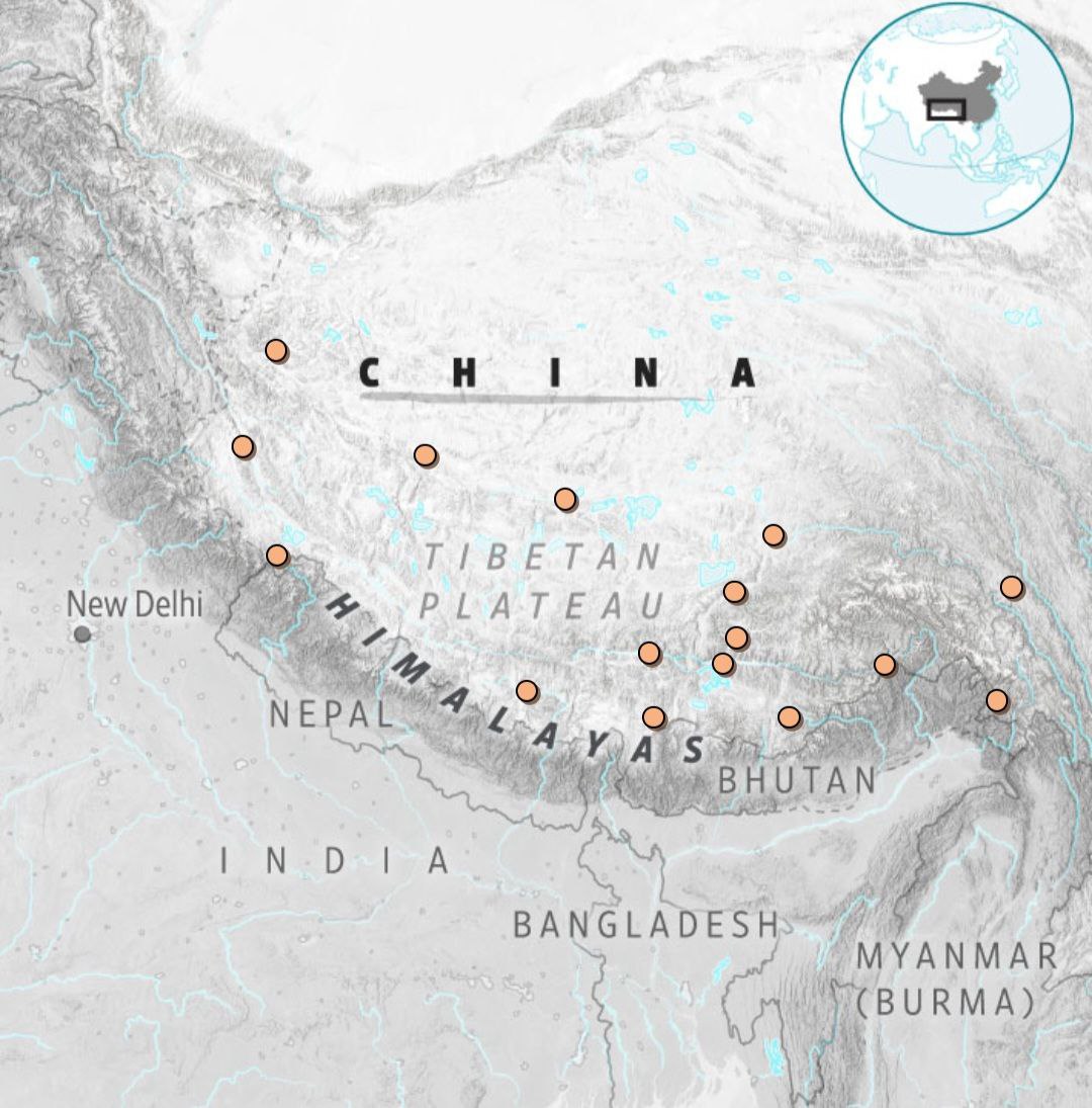
(DEFENCE SECURITY ASIA) — In the oxygen-starved expanse of the Tibetan Plateau—where elevations exceed 14,000 feet and human physiology itself becomes a limiting factor—China is executing one of the most consequential military infrastructure transformations of the 21st century, as newly analysed satellite imagery and intelligence assessments confirm that the People’s Liberation Army Air Force is constructing or expanding at least 16 high-altitude air bases along the India-Tibet frontier, a development that fundamentally recalibrates the regional balance of power in the Himalayas.
These bases, positioned along the Line of Actual Control and supported by a dense constellation of hardened shelters, extended runways, underground fuel depots and missile storage facilities, are designed to sustain persistent air operations despite extreme weather, thin air and sub-zero temperatures, enabling Beijing to project overwhelming air and missile power deep into contested border regions that have historically constrained conventional military operations.
Equipped to host advanced platforms such as CH-5 and CH-7 High-Altitude Long-Endurance unmanned aerial vehicles, GJ-11 combat collaborative aircraft, J-20 fifth-generation stealth fighters, and large numbers of J-10 and J-11 multi-role fighters—while being shielded by People’s Liberation Army Rocket Force ballistic missile brigades—these facilities represent a deliberate shift from reactive border defence to proactive dominance through layered, integrated joint operations.
The strategic intent underpinning this transformation was encapsulated by one defence analyst who observed that “China’s high-altitude military infrastructure is not just about connectivity—it’s a calculated move to assert dominance over India in a region where geography has long favored the defender,” a statement that underscores Beijing’s determination to neutralise terrain advantages through technology, scale and endurance.
Valued conservatively at several billion US dollars—estimated to exceed US$20 billion (approximately RM94 billion) when factoring runway construction, hardened shelters, missile facilities and logistical networks—the programme signals that China is prepared to absorb extraordinary financial and human costs to secure decisive operational leverage over its principal continental rival, India.
More significantly, the emergence of this high-altitude fortress architecture suggests that Beijing is no longer content with parity or deterrence along the Himalayan frontier, but is instead engineering conditions for rapid escalation dominance, allowing it to seize the initiative across air, missile and information domains within the opening hours of any future crisis.
This article examines how historical precedent, extreme-altitude engineering, next-generation weapon systems and evolving doctrine converge within China’s Himalayan military buildup, and why this transformation increasingly threatens to eclipse India’s defensive posture across one of the world’s most contested and geopolitically sensitive borders.
China’s ability to sustain large-scale aviation and missile operations at such altitudes also reflects a maturing industrial–military ecosystem capable of overcoming oxygen deprivation, reduced engine thrust and accelerated airframe fatigue, challenges that historically imposed severe sortie-rate penalties on high-altitude air forces and limited the tempo of sustained combat operations in mountainous theatres.
By embedding these air bases within a broader lattice of roads, railways, fibre-optic communications and forward-deployed logistics hubs across Tibet and Xinjiang, Beijing is effectively compressing mobilisation timelines and reducing strategic warning for New Delhi, thereby shifting the crisis-stability equation decisively in China’s favour.
The scale and permanence of this infrastructure further indicate that China’s leadership is planning not merely for episodic border crises but for long-duration, high-intensity contingencies in which air dominance, precision strike and information superiority must be maintained continuously rather than surged temporarily.
From an operational standpoint, the dispersion of air assets across multiple high-altitude bases complicates Indian targeting and retaliation planning, forcing New Delhi to account for a far larger set of hardened and redundant nodes that dilute the effectiveness of pre-emptive or counter-air strategies.
Taken together, these developments suggest that the Tibetan Plateau is being transformed from a geographic buffer into an active launchpad for coercive power projection, redefining the Himalayas not as a natural barrier to warfare but as an elevated battlespace optimised for modern, network-centric conflict.
From Galwan to Permanent Militarisation of the Himalayas
The contemporary militarisation of the India-China frontier cannot be understood without reference to the 2020 Galwan Valley clash, an incident that shattered decades of tacit restraint and demonstrated how rapidly localized friction could escalate into lethal confrontation despite the absence of firearms, resulting in the deaths of 20 Indian soldiers and an undisclosed number of Chinese personnel in one of the most violent border encounters since 1962.
Rather than serving as a cautionary episode, Galwan appears to have catalysed a structural shift in Chinese strategic thinking, prompting Beijing to accelerate permanent military infrastructure development across Tibet and Xinjiang as part of a broader effort to ensure that future crises are resolved on terms overwhelmingly favourable to the People’s Liberation Army.
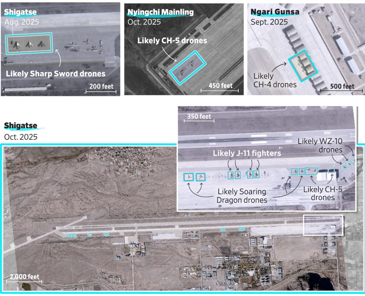
Satellite imagery from 2025 reveals an unprecedented tempo of construction activity, including expanded aprons, hardened aircraft shelters and integrated missile facilities facing India’s Ladakh and Arunachal Pradesh sectors, signalling a move away from seasonal deployments toward year-round force presence capable of sustained high-intensity operations.
Declassified assessments and open-source intelligence indicate that Chinese planners internalised Galwan as a logistics and response-time problem, concluding that the side capable of mobilising airpower, precision fires and ISR assets fastest at altitude would dictate escalation dynamics regardless of infantry presence on the ground.
The extreme conditions of the plateau—hypoxia, temperature extremes and limited road access—have traditionally favoured defensive postures, yet China’s willingness to expose thousands of construction workers to frostbite, altitude sickness and prolonged oxygen deprivation underscores the strategic premium Beijing places on neutralising these constraints.
Workers reportedly rely on oxygen tanks and intravenous fluids to complete runway paving and shelter construction, a human cost that mirrors the broader militarisation drive under President Xi Jinping’s directive to prepare the PLA for “active defence” across peripheral theatres deemed vital to national rejuvenation.
Indian security officials have privately warned that these developments imperil the Siliguri Corridor, with one anonymous source stating that “these bases threaten India’s Chicken Neck—the Siliguri Corridor—potentially isolating the northeast in a conflict,” a scenario that would carry existential implications for India’s internal cohesion and military mobility.
By embedding airpower and missile forces as the vanguard of any future confrontation, Beijing is operationalising a doctrine in which escalation control is achieved not through negotiation but through the credible threat of rapid, multi-domain overmatch along the world’s highest battlefield.
Engineering Air Power at 14,000 Feet: China’s High-Altitude Base Network
The 16 newly constructed or expanded PLAAF bases are distributed across the Tibetan Plateau in a deliberate east-to-west arc extending from Lhunze to Burang and Tingri, each located at elevations exceeding 14,000 feet where air density can reduce aircraft engine performance by up to 50 percent under conventional operating assumptions.
Lhunze Airbase, situated approximately 40 kilometres from Arunachal Pradesh, exemplifies this engineering ambition, with imagery revealing 36 hardened aircraft shelters, expanded parking aprons designed for rapid surge operations, and fortified command facilities built to withstand precision strikes and missile fragmentation.
Tingri Airbase, positioned near Mount Everest at roughly 14,100 feet, features lengthened runways capable of accommodating heavy fighters and support aircraft, reflecting extensive modifications to counter reduced lift and thrust in thin air while maintaining acceptable take-off safety margins.
At these altitudes—comparable to the summit of Pikes Peak in the United States—construction machinery experiences degraded performance and human labour is limited to short work cycles, yet China has completed or upgraded eight airfields and heliports within a single year, an output unmatched by any other military power operating under similar conditions.
The presence of reinforced bunkers with retractable roofs, extensive fuel storage and minimal civilian aviation traffic indicates that these installations are optimised for wartime use rather than dual-use economic development, despite Beijing’s public characterisation of some facilities as civilian airports.
Several bases are co-located with PLARF missile sites, creating tightly integrated strike complexes capable of launching air and missile operations from mutually supporting positions, thereby complicating enemy targeting and enhancing survivability under attack.
Upgrades at Shigatse and Hotan, including advanced air defence systems and electronic warfare infrastructure, suggest that these bases are designed to function as nodes within a broader kill-chain architecture rather than isolated launch points.
Collectively, this network enables coordinated multi-axis operations and drone-fighter teaming tactics that allow Chinese forces to saturate Indian defences from multiple directions, effectively transforming altitude from a constraint into a force multiplier.
Stealth, Drones and Missiles: The Arsenal Behind China’s Himalayan Dominance
At the core of China’s high-altitude posture is a layered arsenal designed to deliver persistent surveillance, precision strike and escalation control across the Himalayas, beginning with the deployment of CH-5 and CH-7 High-Altitude Long-Endurance unmanned aerial vehicles capable of remaining on station for more than 24 hours at extreme altitude.
The CH-7, a stealth-optimised platform that has reportedly completed high-altitude trials, provides Beijing with an ISR and strike asset capable of penetrating contested airspace while evading radar systems such as India’s Uttam AESA, thereby degrading early warning and reaction times.
Complementing these systems are GJ-11 combat collaborative aircraft—often described as “loyal wingmen”—that operate alongside manned fighters to extend sensor coverage, conduct electronic warfare and deliver precision munitions under networked command structures.
Footage released in late 2025 shows GJ-11s flying in formation with J-20 and J-16D aircraft, demonstrating China’s progress toward operationalising AI-enabled man-unmanned teaming at altitude, a capability that significantly enhances survivability and lethality in contested environments.
A state-linked assessment characterised this capability succinctly, noting that “The GJ-11’s flying wing design ensures stealth, making it a game-changer in contested airspace,” a claim consistent with observed design features and operational concepts.
The forward deployment of J-20 “Mighty Dragon” stealth fighters since mid-2024 further amplifies this threat, as the aircraft’s supercruise capability, low observability and long-range PL-15 air-to-air missiles allow it to engage adversaries well before being detected.
J-10 and J-11 fighters provide numerical mass, with more than 100 aircraft reportedly positioned for forward operations, creating a layered force structure that combines quality, quantity and persistence.
On the ground, PLARF ballistic missile units armed with DF-21 and DF-26 systems—each capable of striking targets up to 4,000 kilometres away—anchor this posture, enabling Beijing to threaten Indian airbases, logistics hubs and command centres with little warning.
Strategic Overmatch and the Erosion of India’s Himalayan Advantage
The cumulative effect of China’s high-altitude base network and integrated arsenal is the systematic erosion of India’s traditional reliance on terrain and altitude as defensive advantages, replacing geographic buffers with technological overmatch and operational tempo.
In a conflict scenario, Chinese forces could achieve local air superiority within hours by combining stealth fighters, collaborative drones and long-range missiles to suppress Indian air defences and forward airfields before ground manoeuvre forces are engaged.
The PLARF’s ability to conduct saturation strikes against key nodes—particularly the Siliguri Corridor—introduces a strategic vulnerability that could sever India’s northeastern states from the rest of the country, fundamentally altering escalation calculations.
Defence assessments increasingly emphasise that China’s Himalayan posture mirrors its anti-access strategy in the South China Sea, where layered air and missile defences deter adversary intervention by raising the cost of entry to prohibitive levels.
Beyond military considerations, the visible permanence of these installations exerts psychological and diplomatic pressure, signalling Beijing’s confidence and resolve while complicating New Delhi’s efforts to negotiate from a position of strength.
A strategic analysis of the evolving balance concluded that “China’s military modernization underscores its growing superiority, forcing India into a strategic reckoning,” a judgement that reflects widening asymmetries in force structure and industrial capacity.
As these bases mature, the window for India to contest escalation dynamics narrows, increasing the likelihood that future crises will unfold under conditions set largely by Chinese operational planning.
The Himalayan frontier is thus being transformed from a contested boundary into a theatre of sustained power projection, with profound implications for South Asian stability.
India’s Response, Regional Implications and an Uncertain Future
India has responded by upgrading high-altitude airfields such as Nyoma and deploying Rafale fighters forward, while investing in tunnels, helipads and integrated rocket forces designed to enhance survivability and response speed.
Despite these efforts, significant asymmetries remain, as India’s fighter inventory and missile forces lag behind China’s in both scale and integration, while delays in indigenous programmes such as the Advanced Medium Combat Aircraft constrain long-term parity.
Strategic partnerships within the Quad offer technological and intelligence benefits, yet India’s commitment to strategic autonomy limits the depth of external military integration available to offset Chinese advantages.
Analysts emphasise that deterrence along the Line of Actual Control now hinges less on infantry deployments and more on sustained investment in airpower, ISR and missile defence capable of operating at altitude.
The broader geopolitical ramifications extend beyond South Asia, as intensified Sino-Indian competition intersects with Indo-Pacific dynamics and great-power rivalry, raising the stakes of miscalculation.
Historical experience suggests that unmanaged militarisation along contested borders can entrench security dilemmas, making de-escalation increasingly difficult once permanent infrastructure is in place.
A recent PLA-linked assessment asserted that “China’s deployments dominate Indian power,” signalling Beijing’s perception that the current trajectory favours its strategic objectives.
Unless matched by credible countervailing capabilities or meaningful confidence-building measures, China’s high-altitude fortress may define the Himalayan security environment for decades, casting a long and destabilising shadow over one of the world’s most sensitive frontiers. — DEFENCE SECURITY ASIA