US Navy P-8A Spotted Off Pakistan as Iran “Ghost Tanker Fleet” Fears Escalate Beyond Strait of Hormuz
Surveillance flights near Karachi are raising questions over whether Iranian oil shipments and sanctions-evasion networks have shifted toward Pakistani waters as Washington expands maritime monitoring operations.

(DEFENCE SECURITY ASIA) — The sudden appearance of a US Navy P-8A Poseidon maritime surveillance aircraft off Pakistan’s coastline has expanded the strategic geography of the ongoing US-Iran confrontation from the Strait of Hormuz into the Northern Arabian Sea, introducing a potentially significant escalation in maritime monitoring patterns.
The development has generated heightened scrutiny among defence analysts because the aircraft’s operational profile emerged immediately after Washington intensified its maritime blockade campaign against Iranian shipping, creating questions over whether Tehran’s sanctions-evasion architecture has migrated toward Pakistani waters.
Open-source tracking data circulating across defence monitoring communities suggest the aircraft was operating in an area where Iranian-linked tankers, commercial vessels, and possible sanctions-evasion routes increasingly overlap, producing strategic implications extending well beyond a routine surveillance mission.
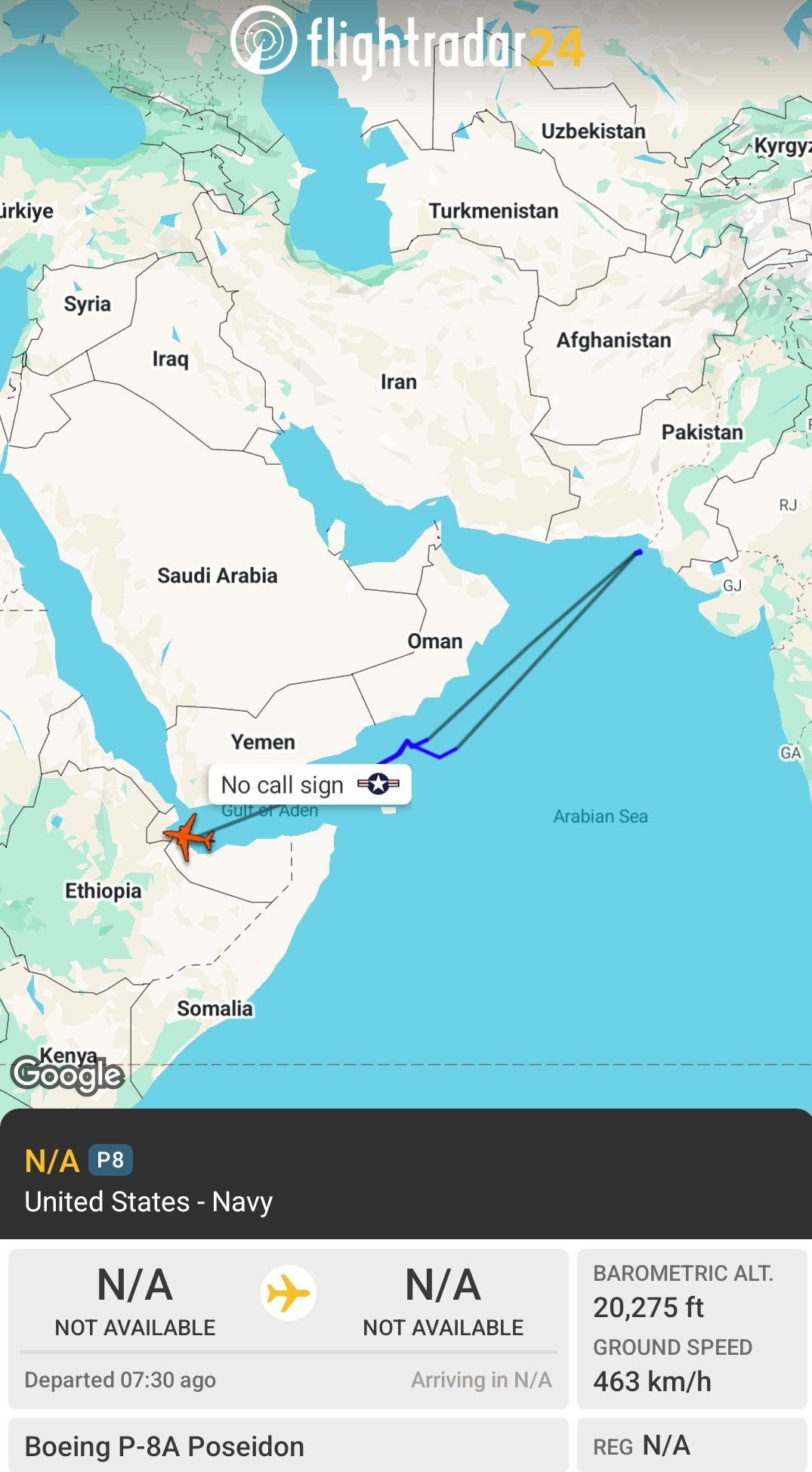
Several OSINT observers tracking military aviation activity, including accounts identifying unusual aircraft movement patterns near Karachi and the Pakistan-India maritime boundary, argued the deployment profile strongly indicated an expanded surveillance mission connected to maritime interdiction efforts.
Although no official confirmation has linked the specific sortie to Iranian tanker movements, analysts note that the aircraft’s timing, operating area, and mission capabilities collectively align with broader American efforts to monitor maritime traffic associated with Iranian oil-export networks.
The absence of official explanation has amplified speculation because strategic reconnaissance assets rarely appear in previously uncommon operating areas without broader force-posture calculations influencing deployment decisions.
Military planners increasingly view surveillance aircraft positioning as geopolitical signalling because reconnaissance patterns frequently reveal future operational priorities before larger force deployments become publicly visible.
The operational timing also coincides with reports describing expanded US maritime enforcement activities involving thousands of military personnel and multiple naval assets across key regional sea lanes.
Analysts therefore assess that the aircraft’s presence may represent an early indicator of expanded American maritime surveillance architecture stretching from the Persian Gulf into the wider Arabian Sea battlespace.
Whether monitoring oil tankers, sanctions-evasion networks, or broader maritime movement patterns, the deployment introduces an additional layer of uncertainty into one of the world’s most strategically critical maritime regions.
READ: Singapore Secures US$2.3 Billion P-8A Poseidon, Torpedoes Deal from US in Major Boost to Regional Anti-Submarine Warfare Capability
Why A P-8A Poseidon Off Karachi Matters Strategically
The deployment attracted unusual attention because US Navy P-8A aircraft have historically concentrated surveillance operations around established chokepoints rather than conducting visible missions close to Pakistan’s coastal maritime environment.
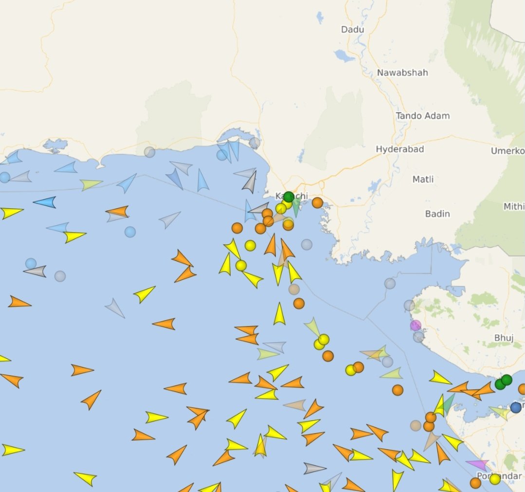
Defence analysts assess that operating near Karachi provides a wider observational envelope over sea routes connecting the Gulf of Oman, Arabian Sea, and eastern approaches toward South Asian waters.
This geographical positioning creates an ideal surveillance corridor for tracking shipping patterns attempting to bypass monitoring efforts concentrated around traditional Gulf maritime chokepoints.
Unlike tactical surveillance platforms, the P-8A Poseidon combines long-duration flight endurance with persistent intelligence collection capability across expansive maritime operating environments.
The aircraft can reportedly remain airborne for more than ten hours while conducting surface-search surveillance, electronic signal collection, communications interception, and long-range vessel identification operations.
Its extensive sensor suite allows operators to develop comprehensive maritime pictures involving merchant vessels, warships, and potentially suspicious tanker activity spread across substantial oceanic areas.
The aircraft’s capabilities therefore make it highly suitable for identifying unusual vessel patterns associated with sanctions-evasion activities involving deliberate route deviations and concealed shipping behavior.
Its deployment profile additionally suggests surveillance priorities extending beyond conventional anti-submarine warfare roles commonly associated with Poseidon aircraft operations.
The location itself indicates interest in maritime logistics patterns rather than immediate tactical military threats emerging directly from regional naval forces.
This distinction matters because strategic maritime surveillance frequently precedes broader operational enforcement activity across contested commercial shipping environments.
Iranian Tanker Evasion Tactics Under Intensifying Scrutiny
The broader American maritime blockade reportedly initiated around April 2026 aimed to disrupt Iranian oil exports and associated revenue streams amid intensifying US-Iran tensions.
Reports circulating through multiple tracking communities suggested that dozens of Iranian-linked vessels had already experienced interception, redirection, seizure, or operational disruption under expanding enforcement measures.
Analysts argue such pressure naturally incentivizes the development of increasingly sophisticated maritime sanctions-evasion methods across broader geographic areas.
Historical tanker evasion patterns demonstrate that vessels attempting sanctions avoidance frequently adopt highly adaptive routing and concealment techniques.
These techniques reportedly include AIS manipulation, transponder shutdown procedures known as “dark mode,” and location spoofing intended to obscure actual vessel movement patterns.
Such activities complicate maritime domain awareness because ship tracking increasingly depends upon integrated sensor fusion rather than standard commercial vessel identification systems.
Analysts also note that sanctions-evasion networks frequently exploit crowded commercial maritime environments where legitimate shipping traffic creates concealment opportunities.
Pakistani coastal approaches potentially provide operational advantages because extensive shipping movement near Karachi naturally complicates identification and tracking efforts.
The migration of maritime activity toward less intensely monitored regions therefore represents a logical adaptation pathway for networks attempting operational survival.
The deployment of high-end surveillance assets consequently reflects broader recognition that enforcement strategies must evolve alongside evasion methodologies.
The “Ghost Armada” Theory Emerging Around Pakistani Waters
Several defence observers monitoring maritime traffic increasingly referenced the possibility of loitering Iranian-linked vessels operating off Pakistan under what some analysts informally described as a “Ghost Armada” scenario.
The phrase generally refers to dispersed vessel clusters employing concealment practices intended to complicate monitoring and attribution efforts across crowded maritime environments.
Although definitive evidence remains limited, observers noted unusual shipping patterns potentially consistent with loitering behavior near regional sea approaches.
Analysts stress that such interpretations remain hypotheses rather than verified operational findings because publicly available information possesses significant limitations.
Nevertheless, maritime evasion frameworks increasingly depend upon ambiguity because uncertainty itself complicates interdiction decision-making processes.
Commercial traffic density near Pakistani waters naturally creates operational conditions where identifying suspicious vessel behavior becomes substantially more difficult.
Analysts also note that extended anchorage patterns occasionally precede ship-to-ship transfer operations involving cargo redistribution between separate maritime platforms.
Ship-to-ship transfer methods historically appear within sanctions-evasion ecosystems because cargo ownership trails become increasingly difficult to establish afterward.
Such techniques have appeared previously across multiple sanctions environments involving energy exports and restricted commercial activities.
The possibility that surveillance assets are examining these operational patterns therefore remains strategically plausible despite the absence of formal confirmation.
Ship-To-Ship Transfers May Be Driving Surveillance Priorities
Among the strongest theories circulating within OSINT communities involves possible monitoring of ship-to-ship transfer activity involving Iranian-associated energy cargoes.
Ship-to-ship transfer operations enable crude oil movement between vessels without requiring traditional port infrastructure or customs processing procedures.
These operations often occur in offshore locations where monitoring coverage remains relatively fragmented compared with controlled port environments.
Strategically, such transfers complicate enforcement because cargo origin tracing becomes increasingly difficult after secondary vessel movement occurs.
Analysts therefore consider these methods especially attractive for sanctions-evasion ecosystems seeking continuity of energy export operations.
Pakistani maritime approaches could theoretically provide advantageous positioning because they remain connected to broader regional shipping corridors leading toward Asian energy markets.
Routes toward the Strait of Malacca represent especially significant commercial pathways because major Asian economies maintain substantial energy import requirements.
Reports previously suggested that some tankers attempted routing patterns hugging coastlines or remaining near territorial maritime boundaries.
Such movement profiles potentially complicate interception decisions because maritime jurisdictional calculations become increasingly sensitive and politically complex.
The deployment of advanced surveillance platforms therefore potentially reflects a broader effort to establish clearer maritime pattern-of-life intelligence across emerging operating areas.
READ: India Approves US$3.5 Billion P-8I Expansion Despite Soaring Costs as Chinese Submarine Threat Grows Across Indian Ocean
Surveillance Expansion Signals Broader Force-Posture Evolution
The most strategically significant implication may not involve individual tankers but rather the geographic expansion of American maritime surveillance architecture itself.
Military planners increasingly evaluate force posture through reconnaissance deployment patterns because surveillance assets frequently indicate shifting operational priorities before visible fleet movement occurs.
The appearance of a P-8A near Pakistan suggests surveillance boundaries potentially extending significantly beyond traditional Gulf operational zones.
Such expansion creates broader intelligence coverage capable of identifying adaptation strategies emerging among regional maritime networks.
It also demonstrates how maritime competition increasingly extends into grey-zone environments operating below thresholds associated with direct naval confrontation.
Strategic competition increasingly centers around logistics routes, energy flows, and commercial shipping ecosystems rather than conventional battlefield engagements.
Analysts note that maritime surveillance today functions as both intelligence collection and geopolitical signalling simultaneously.
The deployment therefore potentially communicates that Washington intends to monitor not only choke points but also secondary pathways supporting broader regional logistics movement.
No formal statement currently confirms the exact mission objective behind these flights, leaving considerable analytical uncertainty surrounding operational priorities.
Yet viewed collectively through timing, geography, aircraft capabilities, and broader blockade developments, the surveillance activity strongly suggests an emerging operational theatre extending far beyond Iran’s immediate maritime perimeter.