Three Long-Range Radars to serve as Malaysia’s “Eyes and Ears” to Monitor South China Sea
The three long-range radars, both upcoming and already acquired, will serve as crucial "eyes and ears" for Malaysia in monitoring any attempts by foreign entities to intrude into its waters in the South China Sea.

(DEFENCE SECURITY ASIA) — In a strategic move to enhance its monitoring capabilities on South China Sea, Malaysia is set to acquire and has already acquired three long-range radars, poised to act as the nation’s “eyes and ears”, detecting any attempts by foreign entities to breach its airspace and waters in the vital waterways.
This development comes amid recurring incursions by Chinese coast guard vessels into the country’s Exclusive Economic Zone (EEZ), particularly near Beting Patinggi Ali, an area rich in Malaysia’s oil and gas resources.
Former Defense Minister Datuk Seri Mohamad Hasan emphasized the critical importance of safeguarding Malaysia’s interests in the South China Sea, stating that the waters around Beting Patinggi Ali contribute approximately 25 percent of the country’s Gross Domestic Product (GDP).
Therefore, he emphasized that the country’s interests in the South China Sea must be defended “at any cost.”
Among the nation’s most valuable assets in the relevant maritime area is the Kasawari Gas Field, situated in waters with a depth of approximately 108 meters within Block SK316, about 200 km north of Bintulu, Sarawak.

Discovered in November 2011, the Kasawari Gas Field is estimated to hold a substantial three trillion cubic feet (TCF) of natural gas, ready for extraction, processing, and commercialization.
PETRONAS’ discovery of the Kasawari Gas Field further solidifies Malaysia’s position as one of the world’s leading exporters of Liquified Natural Gas (LNG).
The importance of these assets underscores the need for constant vigilance and protection in the South China Sea.
“Taking into account areas such as the Kasawari Gas Field and Beting Patinggi Ali, which contribute nearly 25 percent to Malaysia’s Gross Domestic Product (GDP), where our oil wells and gas reservoirs are located, it is imperative to safeguard them at any cost,” according to Mohamad Hasan.

The question arises: What are the three “eyes and ears” of the country that will monitor movements in the South China Sea 24/7?
In early December, Malaysia and France finalized the Letter of Acceptance (LOA) for the Ground Master 400 Alpha (GM400) long-range air defense radar.
Valued at approximately RM200 million, the GM400 radar will be deployed in Bintulu, Sarawak, facing the South China Sea, to monitor airspace sovereignty along coastal areas and the EEZ.
The GM400, the latest addition to the “Ground Master” radar family, boasts enhanced detection capabilities, extending up to approximately 515 km (278 nautical miles), a 10 percent improvement.
It can effectively track high-speed fighter aircraft, guided missiles, helicopters, and unmanned aerial systems. Notably, the GM400’s unique feature is its ability to simultaneously track low-flying tactical drones and high-altitude targets like bombers at a distance of 515 km.
The GM400 radar in Bintulu will complement another long-range air defense radar, the AN/TPS-77, manufactured by Lockheed Martin, stationed in Labuan.
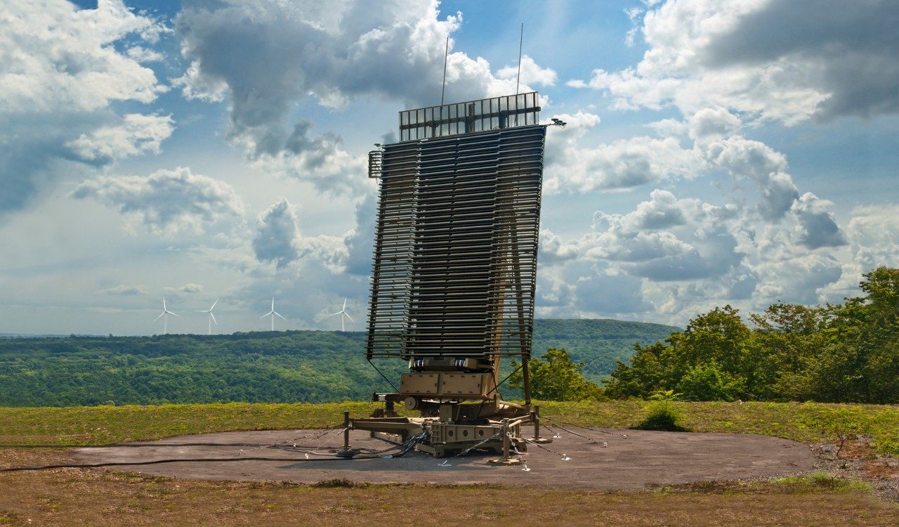
With a coverage range of about 470 km (250 nautical miles), the AN/TPS-77 is a mobile radar capable of deployment via C-130 Hercules aircraft, trucks, or trains.
The U.S. government provided the AN/TPS-77 as part of its contribution to Malaysia’s defense capabilities.
The third set of “eyes and ears” for monitoring maritime and aerial movements in the South China Sea will be stationed on Malaysia-owned Layang-Layang Islands, a part of the Spratly Island.
This long-range radar system will facilitate surveillance beyond the Exclusive Economic Zone in the Spratly Islands.
As tensions persist over territorial claims in the resource-rich Spratly Islands, Malaysia reinforces its monitoring capabilities to ensure the protection of its economic interests and territorial sovereignty in the South China Sea.
“The long-range radar on Layang-Layang Island will assist us in monitoring any movements occurring outside the Exclusive Economic Zone (EEZ) in the Spratly Islands,” he stated in the Parliament last October.
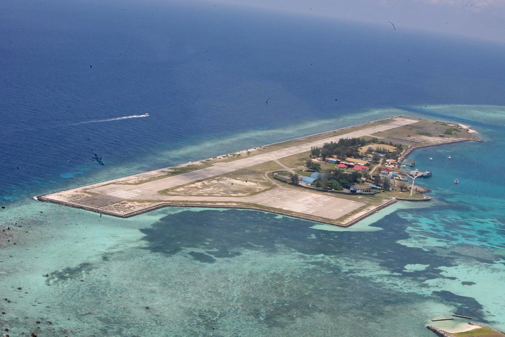

The acquisition of the long-range radar for placement on Layang-Layang Island has already been approved by the National Security Council, he added.
Layang-Layang Island in the South China Sea is located approximately 162 nautical miles northwest of Kota Kinabalu, clearly indicating its ownership by Malaysia under the United Nations Convention on the Law of the Sea (UNCLOS 1982).
The Royal Malaysian Navy (TLDM) also deploys its personnel at the LIMA Station on Layang-Layang Island.
The Spratly Islands, reputedly rich in oil and gas, are a contentious hotspot, with regional countries such as China, Vietnam, and the Philippines asserting claims over the entire archipelago or parts of it.
China, for instance, has transformed several coral reefs in the Spratly Islands into military bases, stationing military aircraft, radar and communication facilities, as well as warships. — DSA

DEFENCE SECURITY ASIA APPS
To advertise contact: [email protected]