Pakistan Launches PRSC EO-3 Satellite from China, Strengthening Strategic ISR, Space Surveillance and National Security Power
The successful launch of Pakistan’s fully indigenous PRSC EO-3 electro-optical satellite from China marks a major leap in sovereign Earth observation, strategic ISR capability, and long-term space-based national security architecture.

(DEFENCE SECURITY ASIA) — Pakistan’s successful launch of the fully indigenous PRSC EO-3 electro-optical satellite from China marks far more than another orbital insertion, because it strengthens Islamabad’s strategic intelligence architecture at a moment when space-based surveillance is becoming central to national security and state resilience.
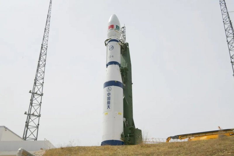
The launch from the Taiyuan Satellite Launch Center in Shanxi Province confirms that Pakistan is accelerating its transition from dependence on foreign remote-sensing support toward sovereign Earth observation capability, while simultaneously deepening the operational depth of its long-term strategic partnership with China.
Prime Minister Shehbaz Sharif described the mission as proof of the professional excellence of SUPARCO’s scientists and engineers, while officials from SUPARCO and ISPR called it a historic milestone toward self-reliance in space technology, language that reflects both national prestige and hard security calculations.
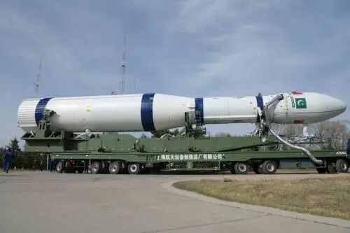
Launched aboard a Long March-6 carrier rocket at 8:15 p.m. Beijing Time on April 25, PRSC EO-3 successfully separated and entered its planned low Earth orbit, most likely a sun-synchronous orbit optimized for repeatable high-resolution Earth observation missions.
The satellite becomes the third completed node in Pakistan’s PRSC-EOS constellation, finalizing a three-satellite electro-optical architecture designed to support disaster response, land management, agricultural monitoring, environmental security, and increasingly sophisticated national surveillance requirements.
Although officially framed around civilian development priorities, the strategic value of high-resolution electro-optical imaging lies equally in persistent situational awareness, logistics mapping, and infrastructure monitoring across both domestic and regional operational theatres.
The completion of the PRSC-EOS triad gives Pakistan a far more resilient orbital reconnaissance framework, because constellation-based coverage reduces revisit gaps and strengthens continuous observation over critical infrastructure, border regions, and climate-vulnerable zones.
At a time when regional competitors are integrating space assets directly into military planning and national crisis management, EO-3 signals that Pakistan views sovereign satellite intelligence not as a prestige project, but as a core pillar of long-term strategic deterrence and state capacity.
READ: China’s Space Edge: How Beijing Helped Pakistan Shoot Down Indian Jets With Satellite Intelligence
Completing Pakistan’s Indigenous EO Constellation
PRSC EO-3 is the final component of the Pakistan Remote Sensing Satellite Electro-Optical System, completing a constellation originally designed around three domestically developed optical satellites—EO-1, EO-2, and EO-3—under SUPARCO’s broader Space Vision 2040 roadmap.
PRSC EO-1 was launched on January 17, 2025, from Jiuquan aboard a Long March-2D rocket, while EO-2 entered orbit earlier in 2026, making EO-3 the mission that transforms the program from demonstration capability into a functioning national observation network.
SUPARCO states that the satellite was fully designed, developed, and built at its Satellite Research and Development Center, making it Pakistan’s most significant indigenous step yet in the field of electro-optical satellite engineering and remote sensing autonomy.
The platform belongs to the small satellite class but exceeds 500 kilograms, making it Pakistan’s largest domestically developed satellite to date and representing a notable industrial progression beyond earlier foreign-assisted orbital assets such as PRSS-1 and PakTES-1A.
Its estimated five-year design life gives Pakistan a medium-term operational window to stabilize national observation requirements while improving domestic spacecraft manufacturing, payload refinement, and future launch vehicle ambitions that remain under long-term development.
The constellation architecture also creates redundancy, because multi-satellite tasking improves revisit rates, reduces observation gaps caused by weather or orbital geometry, and strengthens the continuity of strategic imagery required for both civil governance and security planning.
Ground operations are supported through stations in Islamabad and Karachi, ensuring national command, payload control, and data exploitation remain within Pakistan’s own operational ecosystem rather than depending entirely on external processing infrastructure.
This constellation approach matters because satellite sovereignty is not measured only by launch success, but by sustained control of imaging cycles, mission tasking priorities, and secure data ownership across national decision-making institutions.
High-Resolution Imaging and AI-Enabled Observation
PRSC EO-3 carries a high-resolution electro-optical payload designed for multi-spectral imaging, with expected imaging performance believed to be in the approximately one-meter class, placing it within the practical threshold for high-value terrain and infrastructure analysis.
Such resolution enables effective land mapping, agricultural classification, flood assessment, environmental monitoring, and urban planning, while also supporting strategic monitoring of transport corridors, critical facilities, border regions, and disaster-prone zones requiring rapid governmental response.
Although exact ground sampling distance, spectral band details, revisit rates, and swath width remain undisclosed, the satellite is expected to operate in a sun-synchronous orbit where consistent lighting conditions improve repeatable observation quality and analytical precision.
One of the most important reported upgrades is the Multi-Geometry Imaging Module, which allows multi-angle observation and agile stereo imaging, significantly improving terrain modelling accuracy and three-dimensional assessment of infrastructure or environmental changes.
This capability is particularly relevant for floodplain analysis, landslide prediction, and strategic route mapping, where elevation interpretation and terrain fidelity directly influence both civil emergency planning and military logistics forecasting under crisis conditions.
EO-3 also reportedly carries an onboard AI-powered data processing unit capable of conducting real-time analysis directly on the satellite, reducing latency between image capture and actionable intelligence while improving bandwidth efficiency for critical data transmission.
This is strategically important because traditional remote sensing systems depend heavily on ground-based post-processing, whereas onboard AI allows prioritization of mission-relevant targets and faster decision support during fast-moving disasters or operational contingencies.
An advanced energy storage system further improves mission reliability by supporting payload endurance and power stability, particularly important for small satellite architectures where power margins directly affect operational tempo and imaging flexibility.
These experimental payloads indicate that EO-3 is not merely another imaging satellite, but a technology validation platform intended to push Pakistan’s indigenous capability beyond observation into smarter autonomous orbital mission management.
China’s Launch Support and Strategic Space Partnership
The satellite was launched from Taiyuan Satellite Launch Center using China’s Long March-6 rocket, marking the 640th flight in the Long March series and reinforcing Beijing’s role as the principal external enabler of Pakistan’s orbital access strategy.
Launch services were provided by China Great Wall Industry Corporation under a bilateral agreement signed in 2022, and EO-3 represents the third successful Chinese launch supporting Pakistan’s PRSC-EO constellation development.
This arrangement reflects structural reality rather than symbolic diplomacy, because Pakistan currently lacks a domestic heavy-lift launch vehicle capable of independently placing satellites of this class into reliable sun-synchronous orbit.
As a result, Chinese launch infrastructure functions as a strategic multiplier for Pakistan’s space ambitions, allowing Islamabad to focus domestic resources on payload design, satellite engineering, and mission applications rather than immediate launch vehicle independence.
Interior Minister Mohsin Naqvi and other officials framed the mission as further evidence of deepening Pakistan-China friendship, but the more consequential implication lies in how bilateral cooperation is extending from defence procurement into persistent orbital infrastructure.
Space cooperation now joins fighter aircraft programs, missile collaboration, naval modernization, and digital systems integration as another layer of strategic interdependence shaping the long-term security relationship between Islamabad and Beijing.
For China, supporting Pakistan’s indigenous observation capacity strengthens a trusted regional partner without direct operational exposure, while also reinforcing Beijing’s role as a global provider of strategic launch services and space-industrial influence.
For Pakistan, repeated successful launches through Chinese systems reduce strategic vulnerability created by delayed domestic launch capability and accelerate institutional confidence in indigenous spacecraft programs under operational timelines that matter now.
This makes EO-3 not simply a national satellite mission, but part of a broader regional power architecture where access to orbital infrastructure increasingly defines strategic autonomy and decision-making independence.
Civil Development Mission with Dual-Use Strategic Value
SUPARCO officially describes EO-3 as the edifice of an integrated national Earth Observation System designed to support disaster management, environmental protection, agriculture assessment, natural resource surveying, and sustainable development policy across Pakistan.
These are legitimate national priorities because Pakistan faces repeated flooding, climate stress, agricultural volatility, and rapid urban expansion, all of which demand accurate geospatial intelligence for policy decisions with major economic consequences.
Improved flood prediction alone carries significant strategic value, because Pakistan’s recurring monsoon disasters create national security effects through infrastructure damage, food insecurity, internal displacement, and economic disruption measured in billions of dollars.
Accurate agricultural classification also directly affects food security planning, where satellite-derived crop intelligence supports resource allocation, irrigation management, and national resilience against climate-driven production instability in strategically sensitive regions.
Environmental monitoring strengthens long-term resource governance by enabling better oversight of forests, water systems, land degradation, and ecological pressure points that increasingly intersect with social stability and internal security management.
Yet Earth observation systems are inherently dual-use platforms, because the same high-resolution imagery used for development planning can also support border awareness, route monitoring, infrastructure security, and strategic pattern analysis.
This does not automatically imply offensive military application, but it does mean that the distinction between civilian and security utility becomes increasingly blurred once sovereign persistent imaging enters national command structures.
For policymakers and military planners alike, the real importance lies in decision speed, because the state that sees faster usually responds faster, and response speed often determines strategic advantage more than platform size alone.
EO-3 therefore expands Pakistan’s governance toolkit while simultaneously strengthening the intelligence foundation that modern states require for both national development and strategic risk management.
READ: Pakistan Activates AM-350S and Machaan AESA Radars with China-Backed Satellite Link, Reshaping South Asia’s Air Defense Balance
Space Vision 2040 and the Next Phase of National Capability
Pakistan’s earlier satellites PRSS-1 and PakTES-1A, launched together in 2018, established baseline remote-sensing access, but the PRSC-EO series represents the first truly indigenous electro-optical leap built around domestic engineering ownership rather than partial external dependence.
That distinction matters because technological sovereignty is cumulative, and repeated indigenous design cycles create the institutional knowledge necessary for future military-grade imaging systems, communications satellites, and eventually more advanced strategic orbital assets.
SUPARCO’s longer-term ambition under Space Vision 2040 includes broader self-reliance across satellite development, national applications, and eventually indigenous launch vehicle capability, although heavy-lift launch independence remains a distant objective rather than an immediate milestone.
Until then, the priority is constellation maturity, mission reliability, and technical disclosure following in-orbit commissioning, particularly regarding exact orbital parameters, spectral performance, and final imaging resolution specifications still awaiting formal publication.
Analysts will closely watch whether EO-3 achieves sustained near one-meter performance, because sub-meter to low-meter imaging is the threshold where Earth observation begins to reshape not only development planning but also strategic surveillance credibility.
If the system performs as expected, Pakistan gains a durable national sensor layer capable of supporting climate adaptation, infrastructure security, and operational awareness without persistent dependence on foreign imagery providers or delayed intelligence access.
The economic logic is equally important, because sovereign geospatial intelligence reduces procurement costs for external data services while improving policy precision across sectors whose financial exposure reaches far beyond the satellite’s development budget.
Although official program cost figures remain undisclosed, the strategic return on persistent national observation can exceed billions of dollars in avoided disaster losses and infrastructure planning efficiency, making the investment disproportionately valuable.
In strategic terms, PRSC EO-3 is not only a satellite in orbit, but a statement that Pakistan intends to compete for national resilience, decision sovereignty, and technological credibility in the increasingly contested domain above the atmosphere.