
Iran Strikes U.S. Navy Destroyer? Satellite Image Shows Fire on Arleigh Burke Warship in Arabian Sea as IRGC Claims Ghadr-380 Missile Hit
Low-resolution satellite imagery showing fire aboard a U.S. Navy Arleigh Burke-class destroyer in the Arabian Sea is intensifying scrutiny after Iran’s IRGC claimed a long-range Ghadr-380 anti-ship missile strike against the warship during escalating U.S.–Iran maritime confrontation.

(DEFENCE SECURITY ASIA) — The circulation of low-resolution satellite imagery depicting what appears to be a fire burning across the deck of a United States Navy Arleigh Burke-class guided-missile destroyer operating in the Arabian Sea has triggered urgent strategic scrutiny among defence analysts, because the incident potentially signals a direct Iranian missile strike against a front-line American surface combatant during escalating US-Iran maritime confrontation.
Iran’s Islamic Revolutionary Guard Corps (IRGC) quickly claimed responsibility for a “powerful strike” conducted more than 600 kilometres from Iranian territory using advanced anti-ship cruise missiles, with officials asserting that the attack was executed under Operation True Promise 4 and caused extensive fires aboard the American destroyer and a nearby logistics tanker supporting its operations.
A commander of the IRGC Navy, asserted that Iran’s Ghadr-380 anti-ship cruise missile was capable of penetrating advanced naval defence networks and “creating hell for enemy warships,” a declaration that analysts interpret as strategic signalling designed to challenge the survivability assumptions surrounding the United States Navy’s Aegis-equipped Arleigh Burke-class destroyers deployed across the Indian Ocean theatre.
However, the available imagery remains low resolution and therefore insufficient to verify the presence of structural damage, missile impact points, or casualties, creating a complex information environment in which Iranian operational claims, satellite evidence, and the absence of official confirmation from the United States Navy generate competing narratives requiring cautious technical and geopolitical evaluation.
The alleged strike occurred in the Arabian Sea, a maritime region that functions as a logistical bridge between the Persian Gulf and the wider Indian Ocean energy transport network, where US naval task groups maintain persistent forward deployment to safeguard sea lines of communication and deter Iranian anti-access strategies around the Strait of Hormuz.
For global defence planners, the incident represents a potential test case in the evolving contest between advanced surface combatants equipped with layered missile defence systems and increasingly sophisticated long-range anti-ship weapons developed by regional powers seeking to offset conventional naval superiority through asymmetric strike capabilities.
Arleigh Burke Destroyer Force Posture in the Arabian Sea
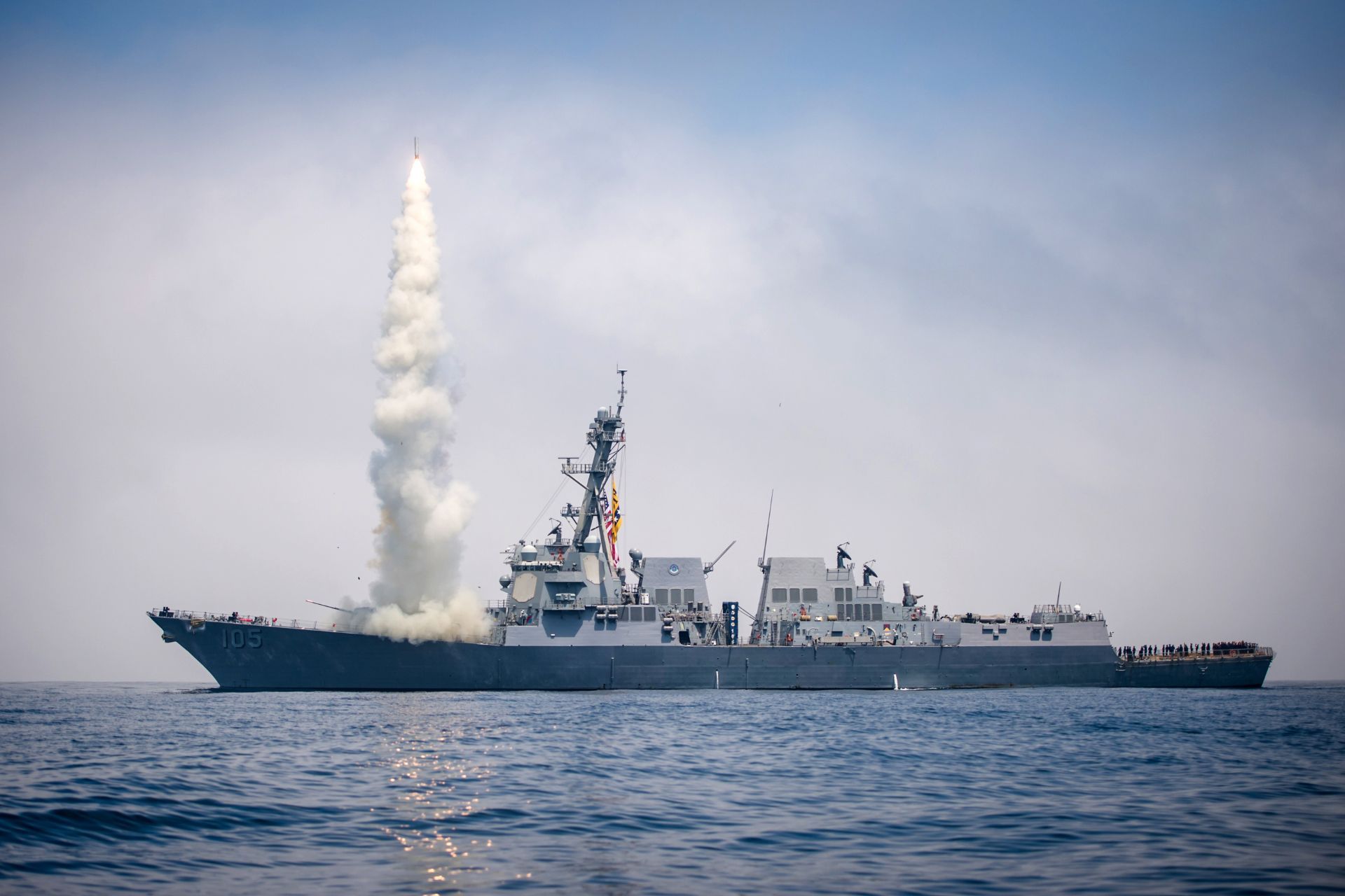
The Arleigh Burke-class destroyer fleet represents the backbone of the United States Navy’s forward-deployed surface combatant architecture, with more than seventy vessels operating globally and serving as the primary maritime platform for ballistic missile defence, multi-domain strike operations, and sea control missions across contested maritime theatres.
These destroyers derive their combat effectiveness from the Aegis Combat System integrated with powerful radar architectures capable of simultaneously tracking hundreds of airborne and surface threats, enabling coordinated defensive and offensive operations that combine missile interception, electronic warfare, and precision strike capabilities.
The original Flight I variant established the baseline architecture for the class with a displacement of approximately 8,300 tons and a hull design engineered for survivability under high-intensity naval combat conditions, reflecting Cold War-era assumptions about missile warfare and fleet defence requirements.
Subsequent Flight II upgrades incorporated enhanced electronic warfare suites and improved communications systems that expanded the destroyer’s ability to integrate into network-centric warfare architectures, enabling real-time coordination with allied aircraft, submarines, and surveillance platforms.
Flight IIA vessels introduced expanded aviation facilities capable of supporting two MH-60R Seahawk helicopters, thereby extending the destroyer’s anti-submarine warfare and maritime strike reach well beyond the ship’s own sensor horizon.
Later vessels within the class incorporate vertical launch systems containing up to ninety-six missile cells capable of deploying a mixture of Standard Missile interceptors, Tomahawk land-attack cruise missiles, and anti-submarine rocket systems, creating a flexible weapons architecture suited to multiple operational scenarios.
The most advanced Flight III destroyers feature the AN/SPY-6(V)1 active electronically scanned array radar, which is reportedly thirty times more sensitive than earlier radar systems and dramatically enhances the ship’s ability to detect low-observable aerial threats and track ballistic missiles during complex combat engagements.
Propulsion for the class is provided by four General Electric LM2500 gas turbines producing more than 100,000 shaft horsepower, allowing the destroyers to achieve speeds exceeding thirty knots while sustaining long-range operations across thousands of nautical miles without requiring frequent refuelling.
Crew complements typically exceed three hundred personnel including aviation detachments, reflecting the complexity of operating integrated combat systems that combine advanced radar networks, missile defence architecture, and layered sensor arrays across multiple warfare domains.
The deployment of multiple Arleigh Burke-class destroyers to the Arabian Sea therefore represents a deliberate US force posture designed to project deterrence power across the Indian Ocean maritime corridor while supporting potential long-range Tomahawk strike operations against regional targets.
Satellite Imagery and the Evidence Problem
The satellite imagery circulating among defence observers appears to show a thermal anomaly or visible fire on the deck of an Arleigh Burke-class destroyer, yet the low resolution of the available imagery limits analysts’ ability to determine whether the blaze originated from a missile impact, equipment malfunction, or unrelated onboard incident.
Thermal signatures detected in satellite imagery can indicate localized fires or explosions but cannot independently confirm the presence of missile penetration damage or structural compromise without higher-resolution optical data or synthetic aperture radar imagery capable of resolving fine structural details.
In the current case, the available imagery reportedly lacks sufficient pixel density to identify specific areas of structural damage on the destroyer’s superstructure or missile launch cells, meaning analysts cannot determine whether vital systems such as radar arrays or combat information centres were affected.
The absence of high-resolution follow-up imagery therefore creates a verification gap in which competing interpretations of the event coexist, with Iranian operational claims suggesting a successful strike while the available satellite evidence remains ambiguous.
Commercial satellite providers have previously released detailed imagery showing damage to Iranian naval vessels following US strikes in the region, demonstrating the capability of high-resolution space-based sensors to identify burn marks, blast signatures, and debris patterns following missile impacts.
However, in this case comparable high-resolution imagery of the alleged US destroyer incident has not yet emerged publicly, preventing independent verification of whether the visible fire resulted from combat action or from a non-combat onboard event.
Defence analysts emphasise that even a minor onboard fire can generate visible smoke signatures detectable by satellite sensors, particularly when ships operate in open ocean environments where background heat signatures are limited.
Without detailed imagery showing missile fragments, deck penetration points, or structural deformation patterns, it remains technically impossible to confirm the IRGC’s claim that a Ghadr-380 anti-ship missile struck the destroyer.
The lack of confirmation from the United States Navy further complicates the information environment, because operational security considerations often delay or limit official disclosures regarding incidents involving deployed warships.
As a result, the current episode highlights the increasingly important role of open-source intelligence analysis in modern naval conflicts, where satellite imagery, sensor data, and official statements interact to shape public perceptions of battlefield outcomes.
IRGC Claim of Ghadr-380 Strike
Iran’s Islamic Revolutionary Guard Corps publicly announced that its naval forces executed a long-range missile strike against a US destroyer operating in the Indian Ocean region, framing the operation as a retaliatory response to recent US and Israeli military actions against Iranian targets.
The IRGC stated that the attack formed part of Operation True Promise 4, a campaign Tehran describes as retaliation against hostile strikes, suggesting that the missile engagement was intended both as military action and as strategic signalling directed at Washington and its regional partners.
Iranian officials claimed that the US destroyer was conducting refuelling operations alongside an American tanker when the missile strike occurred, a scenario that would potentially expose the vessels to increased vulnerability during logistical manoeuvres requiring reduced speed and predictable movement patterns.
According to IRGC statements, the Ghadr-380 missile was launched from Iranian territory and successfully struck the destroyer more than six hundred kilometres away, an assertion designed to demonstrate Iran’s ability to threaten US naval assets far beyond the Persian Gulf littoral.
The IRGC further claimed that the missile strike triggered extensive fires aboard both the destroyer and the refuelling tanker, although no independent imagery has yet confirmed damage to multiple vessels within the alleged strike area.
By publicly highlighting the long range of the Ghadr-380 missile, Iranian officials appear to be reinforcing the credibility of their anti-access strategy aimed at deterring US naval operations near Iranian maritime approaches.
Iran also declared the Strait of Hormuz a “war zone” following the alleged strike, signalling that Tehran may be prepared to escalate maritime confrontation by targeting commercial or military shipping passing through the region.
From a strategic communication perspective, the IRGC’s claim functions as both deterrence messaging and information warfare designed to project the image of Iranian missile effectiveness against technologically superior naval forces.
However, the absence of verifiable damage imagery or official confirmation from US authorities means that the operational success of the alleged strike remains uncertain, highlighting the difficulty of separating strategic messaging from confirmed battlefield outcomes.
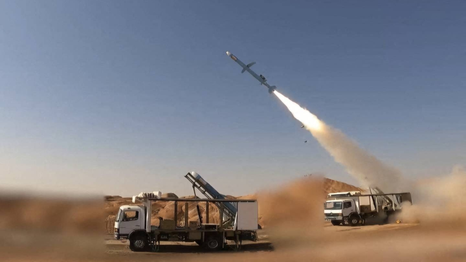
Ghadr-380 Anti-Ship Missile Capabilities
The Ghadr-380 anti-ship cruise missile unveiled by Iran in February 2025 represents a key component of Tehran’s evolving anti-access and area-denial strategy designed to challenge advanced naval forces operating near Iranian maritime approaches.
Unlike earlier Ghadr ballistic missile variants, the Ghadr-380 is reportedly a turbojet-powered cruise missile engineered specifically for maritime strike missions against large surface combatants including destroyers and aircraft carriers.
The missile is launched from a mobile truck-mounted platform using a solid-fuel booster stage that accelerates the weapon to cruising speed before transitioning to turbojet propulsion for sustained long-range flight.
Iranian officials claim the Ghadr-380 has a maximum operational range of approximately 1,000 kilometres, enabling Iranian missile units to target naval vessels operating far beyond the Persian Gulf and into the Arabian Sea or northern Indian Ocean.
The missile reportedly flies at low altitude to reduce radar detection probability while employing a small radar cross-section design intended to complicate interception by shipborne air defence systems.
Guidance architecture reportedly includes advanced anti-jamming technology and autonomous route-selection capabilities allowing the missile to adjust altitude, trajectory, and terminal approach patterns during the attack phase.
Terminal guidance systems maintain target lock until impact, theoretically allowing the missile to correct for evasive manoeuvres performed by the targeted warship during the final phase of flight.
Launch preparation reportedly requires fewer than five minutes and can be conducted by a single operator, increasing operational flexibility and enabling dispersed missile units to conduct rapid strikes from concealed launch locations.
Iranian officials emphasise that Ghadr-380 missiles are stored within hardened underground facilities known as “missile cities,” infrastructure designed to protect launch systems from pre-emptive strikes and ensure survivability during conflict escalation.
Within Iran’s broader maritime strategy, the Ghadr-380 complements drones, naval mines, and fast-attack craft in creating a layered threat environment intended to complicate US naval operations across the Persian Gulf and adjacent maritime regions.
Strategic Consequences for Naval Warfare
If the IRGC’s claim of a successful missile strike on a US destroyer were confirmed through higher-resolution satellite imagery or official disclosure, the incident would represent one of the rare instances in modern naval history in which a major surface combatant was struck during open-ocean operations.
Arleigh Burke-class destroyers are engineered with steel hull construction, Kevlar armour protection, and redundant systems designed to maintain combat capability even after sustaining damage from missile or explosive impacts.
Nevertheless, a missile detonation on the deck or superstructure of a destroyer could damage critical sensors, ignite fires in exposed equipment areas, or temporarily disrupt combat system operations.
Even limited damage requiring the vessel to withdraw for repairs could alter operational force posture in a theatre where US naval units are deployed to conduct missile defence, maritime security patrols, and potential strike missions.
The Arabian Sea location of the alleged incident is strategically significant because it lies near the maritime corridor connecting the Strait of Hormuz with major shipping routes used for global energy transport.
A large proportion of global oil exports transit the Strait of Hormuz each day, meaning any escalation of naval conflict in adjacent waters carries potential implications for international energy markets and maritime security.
For trading nations dependent on uninterrupted sea lanes, including Malaysia and other Indo-Pacific economies, instability in the region highlights the vulnerability of global supply chains to maritime conflict.
The alleged strike also illustrates the growing importance of long-range precision missiles in naval warfare, where relatively inexpensive cruise missiles can threaten high-value warships costing billions of dollars.
Such dynamics reinforce the strategic reality that modern naval combat increasingly depends on sensor networks, missile defence systems, and electronic warfare capabilities rather than purely on the size or firepower of individual warships.
Until higher-resolution satellite imagery or official naval reporting confirms the circumstances of the incident, the alleged Ghadr-380 strike remains a contested episode that nonetheless underscores the rapidly evolving technological and strategic dynamics shaping maritime security in the Indian Ocean region.

I don’t know how the picture depit an Arleigh because looking at the image it is so degraded I for one can’t tell what it is.