Iran Abandons US GPS for China’s BeiDou, Redrawing the Strategic Map of Middle East Electronic Warfare
Tehran’s decisive shift from US-controlled GPS to China’s BeiDou navigation system marks a structural realignment in missile guidance, electronic warfare resilience, and digital sovereignty across the Middle East.

(DEFENCE SECURITY ASIA) — Iran’s formal abandonment of the United States-controlled Global Positioning System in favour of China’s BeiDou Navigation Satellite System in mid-2025 represents a decisive rupture with Western technological dependence, redefining Tehran’s approach to military survivability, digital sovereignty, and strategic autonomy amid intensifying electronic warfare competition in the Middle East.
The decision followed the June 2025 Israel-Iran conflict, during which extensive GPS disruption paralysed navigation across Iranian airspace and maritime zones, exposing how satellite navigation has evolved into an active battlespace instrument capable of shaping kinetic outcomes, economic continuity, and civilian resilience during high-intensity regional confrontations.
“At times, disruptions are created on this [GPS] system by internal systems, and this very issue has pushed us toward alternative options like BeiDou,” stated Ehsan Chitsaz, Iran’s Deputy Communications Minister, underscoring Tehran’s conclusion that GPS reliance constitutes a structural national-security vulnerability rather than a neutral technological convenience.
Chitsaz further confirmed that Iran’s transition strategy encompasses transportation networks, precision agriculture, internet infrastructure, and strategic logistics chains, reflecting a whole-of-government recalibration designed to insulate the Iranian state from future signal denial, cyber intrusion, and foreign manipulation of critical navigation services.
The strategic shift was publicly reinforced by Zhang Heqing, Counsellor at China’s embassy in Tehran, who confirmed Iran’s complete transition to BeiDou, framing the move as a deliberate effort to reduce dependence on Western-controlled digital infrastructure and embed Iran within China’s expanding satellite-navigation ecosystem.
For Tehran, the adoption of BeiDou is not a technical upgrade but a geopolitical declaration, signalling that reliance on US-controlled space infrastructure now carries unacceptable strategic risk in an era where electronic warfare, sanctions enforcement, and signal degradation are increasingly weaponised by major powers.
This transition also reflects the maturation of China’s BeiDou constellation, operational since 2020 with more than 50 satellites, offering enhanced accuracy, redundancy, and resistance to interference that increasingly rivals, and in contested environments surpasses, the operational resilience of legacy GPS architecture.
By abandoning GPS, Iran has effectively rduced Western leverage over its missile guidance, drone navigation, and precision-strike systems, reshaping deterrence dynamics across the Persian Gulf while signalling to Global South states that technological sovereignty has become inseparable from national defence strategy.
From Strategic Hedging to Full Decoupling: Iran’s Long March Away from GPS Dependency
Iran’s migration toward BeiDou represents the culmination of a decade-long strategic hedging effort, initiated well before 2025, aimed at mitigating the systemic vulnerabilities inherent in dependence on US-controlled satellite navigation during periods of geopolitical hostility and sustained military pressure.
As early as 2015, Tehran signed a memorandum of understanding with Beijing to integrate BeiDou technologies, including the establishment of ground reference stations and a space-data collection centre on Iranian soil, signalling early recognition that navigation sovereignty would become a contested strategic domain.
This cooperation was institutionalised under the 25-year Iran-China Comprehensive Strategic Partnership signed in 2021, granting Iran access to BeiDou’s encrypted, high-precision military-grade signals, a privilege typically reserved for China’s closest strategic allies and defence partners.
By 2021, Iranian defence planners had already begun integrating BeiDou into selected missile guidance and secure communications architectures, enabling hybrid navigation configurations that reduced dependence on GPS while preserving operational redundancy during the transition phase.
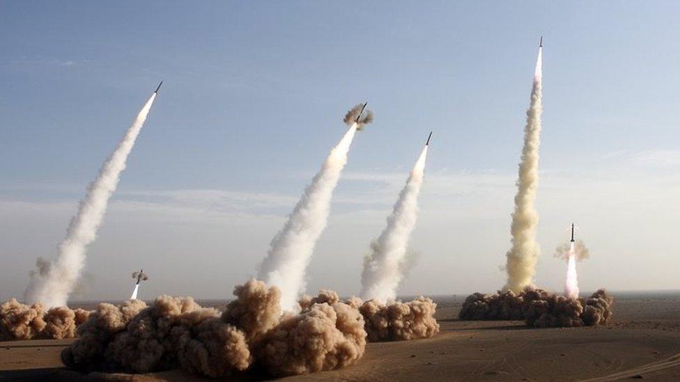
The decisive catalyst emerged during the 12-day Israel-Iran conflict in June 2025, when widespread GPS jamming disrupted nearly 1,000 civilian and military vessels, aircraft, and land-based systems, transforming navigation interference into a nationwide economic and security crisis.
Iranian officials attributed these disruptions to US and Israeli electronic warfare activity, noting that the degradation affected not only missile and drone guidance but also civilian transportation, agricultural precision systems, and critical logistics infrastructure across multiple provinces.
On June 23, 2025, Iran formally deactivated GPS reception nationwide, blocking American signals and completing the transition to BeiDou for both military and civilian applications, a move designed to complicate future drone and missile attacks by denying adversaries familiar signal-interference pathways.
By mid-2025, Iran joined more than 165 countries whose capital cities are observed more frequently by BeiDou satellites than GPS, signalling a structural erosion of American dominance in global navigation architecture and accelerating the fragmentation of the digital commons.
Technical Superiority of BeiDou in High-Intensity Middle Eastern Electronic Warfare Environments
BeiDou’s technical architecture offers decisive advantages over GPS in regions such as the Middle East, where electronic warfare, signal denial, and spoofing operations have become routine operational tools, providing Iran with a navigation system designed from inception to function under contested, degraded, and adversarial electromagnetic conditions.
Unlike GPS, which relies on a constellation of approximately 31 satellites optimised primarily for civilian reliability, BeiDou operates more than 50 satellites across geostationary, inclined geosynchronous, and medium Earth orbits, delivering stronger signal geometry, higher redundancy, and improved availability over Iran’s mountainous and arid terrain.
The system’s military-grade accuracy, reportedly reaching centimetre-level precision for authorised users, offers a substantial improvement over civilian GPS accuracy of three to five metres, directly enhancing the effectiveness of precision-guided munitions, long-range strike systems, and time-sensitive targeting chains within Iran’s integrated air and missile forces.
A 2023 US government advisory board assessment acknowledged that “GPS’ capabilities are now substantially inferior to those of China’s BeiDou,” reflecting a growing recognition within Western defence establishments that Beijing has closed, and in some domains surpassed, the technological gap in satellite navigation resilience.
BeiDou’s integrated short-message communication capability, which allows encrypted text transmission via satellite without reliance on terrestrial networks, provides Iran with an additional layer of command-and-control redundancy absent in GPS, particularly valuable during cyber disruption or infrastructure degradation scenarios.
Iranian officials indicated that during periods of heightened tension prior to the full transition, Tehran deliberately blurred GPS signals domestically to stress-test alternative navigation pathways, a rehearsal that validated BeiDou’s superior resistance to jamming and spoofing under simulated conflict conditions.
For civilian sectors, including maritime navigation, aviation routing, precision agriculture, and Internet of Things infrastructure, BeiDou offers continuity under sanctions-induced technology denial, as compatible chipsets and receivers remain accessible through non-Western supply chains unaffected by US export controls.
In the Middle Eastern operating environment, where terrain-induced signal attenuation and electronic interference are prevalent, BeiDou’s regional optimisation for Asia-Pacific and Belt and Road Initiative corridors delivers stronger signal penetration and reduced latency, directly addressing limitations that have historically constrained GPS performance across Iran’s plateau.
Missile, Drone, and Precision-Strike Implications for Iran’s Deterrence Architecture
The military consequences of Iran’s transition to BeiDou are most pronounced within its missile and unmanned systems force structure, where navigation accuracy, signal integrity, and resistance to external interference directly shape deterrence credibility and strike reliability.
During the June 2025 Israel-Iran conflict, GPS jamming disrupted drone navigation and missile guidance across multiple operational theatres, reinforcing Iranian assessments that continued reliance on US-controlled navigation systems exposes critical vulnerabilities exploitable by technologically superior adversaries.
By adopting BeiDou, Iran significantly reduces the probability that foreign powers can interfere with the navigation or terminal guidance of its ballistic and cruise missile inventory, including systems derived from the Shahab and Sejjil families, whose effectiveness depends on uninterrupted positioning data.
The system’s centimetre-level military accuracy enables more precise targeting, reducing circular error probability and allowing Iranian planners to compensate for conventional warhead limitations through improved guidance rather than escalatory payload enhancements.
BeiDou’s integration into China’s own precision-guided munitions since 2014 provides Iran with a proven template for embedding the system into long-range strike architectures, eliminating reliance on GPS signals that could be selectively degraded during pre-crisis escalation phases.
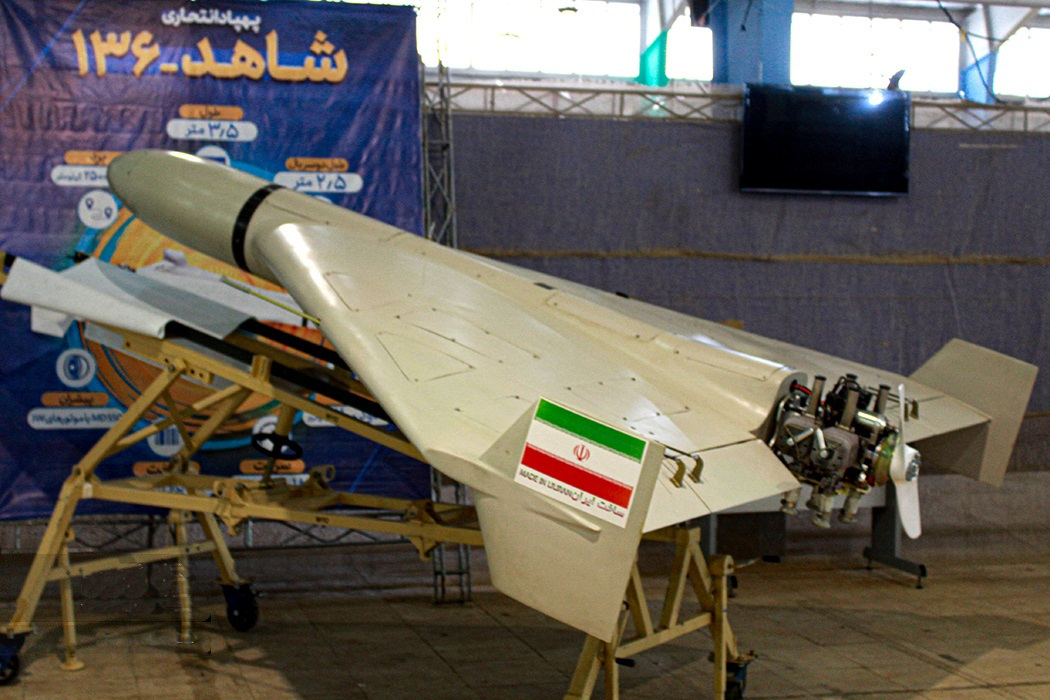
For Iran’s extensive unmanned aerial vehicle ecosystem, including long-endurance surveillance drones and expendable loitering munitions employed by regional proxies, BeiDou enhances autonomous navigation and reduces susceptibility to Israeli GPS spoofing technologies.
“Iran’s decision to switch to BeiDou is driven by its recent experience during the conflict with Israel,” noted assessments circulating within Iranian analytical circles, reflecting a strategic lesson internalised through operational friction rather than abstract planning assumptions.
In the interim period before Iran completes its indigenous navigation satellite programme, expected within five years, BeiDou functions as a strategic bridge, immediately hardening Iran’s deterrence posture while buying time for domestic capability maturation.
Geopolitical Realignment and the Erosion of US Navigation Dominance
Iran’s abandonment of GPS and embrace of BeiDou represents a microcosm of a broader geopolitical realignment, accelerating the fragmentation of the digital commons and undermining long-standing US dominance over global navigation infrastructure.
“Iran’s defection to BeiDou reshaped the US global GPS navigation,” observed international commentary, characterising the move as a deliberate act of digital defiance that weakens Washington’s ability to leverage satellite infrastructure as an instrument of coercive statecraft.
The transition aligns seamlessly with China’s Belt and Road Initiative strategy, which promotes BeiDou adoption across Africa, Southeast Asia, and the Middle East as a counterweight to US technological influence embedded within civilian and military navigation ecosystems.
“Iran has decisively pivoted away from the US-controlled GPS and hitched its strategic wagon to China’s BeiDou,” noted regional observers, warning that the move signals a structural deepening of Sino-Iranian strategic convergence likely to unsettle Western capitals.
Countries including Pakistan, Saudi Arabia, and Russia have already integrated BeiDou into national navigation frameworks, creating interoperability pathways that dilute GPS monopoly power and normalise multipolar navigation governance.
For the United States, the erosion of GPS exclusivity reduces a critical lever of influence historically used for surveillance, sanctions enforcement, and escalation control during crises involving adversarial states.
Chinese analysts have argued that Iran’s decision may encourage neighbouring states to reassess their own dependencies, potentially triggering a cascading regional shift toward diversified navigation architectures less vulnerable to unilateral control.
As BeiDou satellites increasingly observe global capitals more frequently than GPS, the symbolic and operational foundations of US navigation hegemony continue to weaken within an emerging multipolar technological order.
Economic Costs, Sanctions Workarounds, and Civilian Infrastructure Transition
Despite its strategic advantages, Iran’s transition to BeiDou entails significant economic and technical costs, particularly for retrofitting civilian infrastructure across transportation, agriculture, logistics, and digital services under persistent sanctions pressure.
Integrating BeiDou-compatible receivers requires hardware upgrades, software recalibration, and workforce retraining, imposing near-term financial burdens on sectors already constrained by limited access to Western capital and technology.
Nevertheless, Iranian officials have emphasised that BeiDou chipsets and supporting components remain accessible through non-Western supply chains, enabling Tehran to bypass US export controls that have historically restricted GPS-related acquisitions.
For maritime and aviation sectors, uninterrupted navigation reduces insurance premiums, operational delays, and accident risk, translating into long-term economic resilience that offsets initial conversion costs measured in hundreds of millions of US dollars, equivalent to several billion Malaysian Ringgit.
In agriculture, precision navigation improves irrigation efficiency, fertiliser application, and crop yield monitoring, supporting food security objectives while reducing vulnerability to GPS disruption during regional crises.
Civilian adoption challenges remain, as many consumer devices default to GPS, requiring regulatory mandates and phased incentives to accelerate BeiDou integration across smartphones, vehicles, and industrial equipment.
Iranian planners have acknowledged that no satellite navigation system is immune to advanced jamming, prompting parallel investment in backup systems such as enhanced Long Range Navigation, mirroring China’s own national resilience architecture.
Over time, the economic logic of navigation sovereignty increasingly aligns with national security imperatives, reframing BeiDou adoption as a strategic investment rather than a discretionary technological choice.
Navigation Sovereignty and the Future of Middle East Power Dynamics
Iran’s abandonment of GPS in favour of BeiDou marks a watershed moment in Middle Eastern security dynamics, demonstrating how satellite navigation has evolved into a core determinant of military credibility, economic resilience, and geopolitical alignment.
As Deputy Communications Minister Ehsan Chitsaz articulated, the transition reflects a reality where reliance on US-controlled infrastructure is “not a matter of choice, but a necessary step” amid persistent signal disruption and digital monopoly concerns.
By insulating missile guidance, drone operations, and civilian logistics from Western interference, Iran has reduced a critical vulnerability while enhancing deterrence stability across an increasingly volatile regional environment.
The move simultaneously accelerates China’s emergence as a global provider of strategic digital infrastructure, embedding BeiDou within the security architectures of states seeking autonomy from Western technological dominance.
However, reliance on Chinese systems introduces new dependencies, underscoring that navigation sovereignty remains a dynamic balance rather than an absolute condition.
As more nations reassess GPS reliance, satellite navigation will continue to function as a contested domain of great-power competition rather than a neutral global utility.
For Asia and the Middle East alike, Iran’s pivot illustrates how technological choices increasingly shape strategic outcomes, compelling policymakers to integrate navigation sovereignty into long-term defence planning.
In an era defined by electronic warfare and digital coercion, control over positioning signals has become as consequential as control over airspace, redefining the foundations of modern power projection. — DEFENCE SECURITY ASIA