Is China Using Myanmar’s Great Coco Island to Spy on India’s Military in the Bay of Bengal?
Satellite imagery and intelligence analyses suggest that Beijing may have developed a covert signals intelligence (SIGINT) facility on Myanmar’s Great Coco Island, capable of tracking India’s missile tests, submarine operations, and naval movements in the Bay of Bengal.

(DEFENCE SECURITY ASIA) — The Bay of Bengal, once a tranquil maritime expanse between South and Southeast Asia, is now at the centre of intensifying great-power competition.
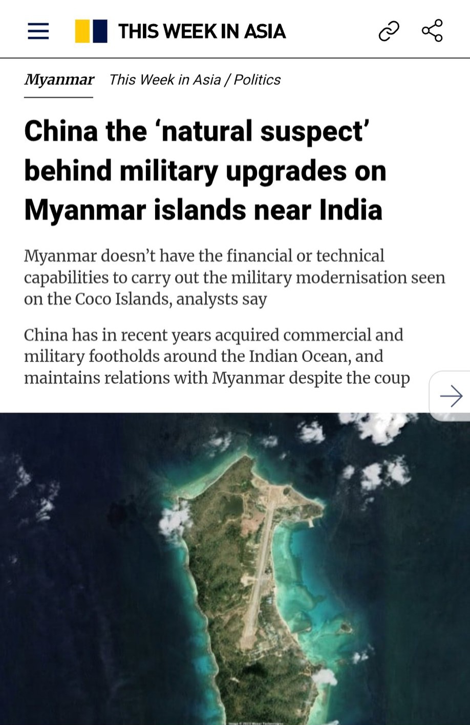
At the heart of this unfolding drama lies Myanmar’s Great Coco Island, a small but strategically located outpost whose recent infrastructure expansion has triggered growing alarm in New Delhi.
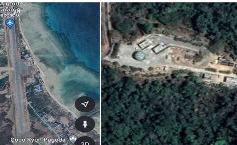
Situated just 55 kilometres north of India’s Andaman and Nicobar Islands, Great Coco Island’s location makes it an ideal vantage point for monitoring Indian naval and missile activities across the eastern seaboard.
Allegations have emerged that China, leveraging its deepening ties with Myanmar’s military junta, has been developing a signals intelligence (SIGINT) base on the island — one capable of intercepting sensitive communications and tracking India’s strategic assets.
While Myanmar’s ruling junta has repeatedly denied the presence of Chinese facilities, its refusal to allow Indian inspection visits has only strengthened suspicions that Beijing may have quietly extended its surveillance network into India’s maritime backyard.
The Great Coco Island also sits astride key maritime routes used by India’s Eastern Naval Command and U.S. naval forces transiting toward the Strait of Malacca, making it an invaluable position for any power seeking maritime domain awareness over the eastern Indian Ocean.
Its proximity to India’s long-range missile test sites in Odisha and the strategic naval dockyard at Visakhapatnam gives potential Chinese sensors on the island the ability to monitor telemetry, radar emissions, and submarine communication patterns with remarkable precision.
Intelligence analysts have warned that even limited electronic infrastructure, such as over-the-horizon radar arrays or signal intercept antennas, could drastically enhance China’s capacity to map Indian naval deployments and calibrate countermeasures for its growing submarine fleet operating in the region.
Furthermore, the island’s expanded airstrip could allow the operation of reconnaissance drones or Y-8GX ELINT aircraft, providing Beijing with a persistent surveillance capability across the Bay of Bengal and tightening its strategic grip on one of the Indo-Pacific’s most contested maritime corridors.
A Strategic Flashpoint Between India, China, and Myanmar
The Coco Islands archipelago, located in Myanmar’s Irrawaddy Division, consists primarily of Great Coco and Little Coco Islands, both of which lie astride critical sea lanes linking the Bay of Bengal to the Malacca Strait.
For decades, these islands have been regarded as a vital maritime outpost for any power seeking to monitor naval movements across the eastern Indian Ocean.
India’s primary concern is the proximity of the islands to its Andaman and Nicobar Command (ANC), which serves as a key forward-operating base for its navy, air force, and army — all tasked with securing India’s interests from the Strait of Malacca to the Andaman Sea.
If Beijing were indeed operating a SIGINT installation on Great Coco Island, it could theoretically monitor radar emissions, radio frequencies, missile telemetry data, and submarine communication traffic emanating from India’s eastern naval and strategic facilities.
This would include signals from the Balasore missile test range in Odisha and India’s Rambilli naval base in Andhra Pradesh, where its nuclear-powered ballistic missile submarines (SSBNs) are believed to operate.
Indian analysts fear that such surveillance could undermine the credibility of India’s sea-based nuclear deterrent, a critical leg of its nuclear triad designed to ensure second-strike capability against potential adversaries.
A Legacy of Suspicion: From the 1990s to Today
Concerns over Chinese activity in the Coco Islands are not new.
In the early 1990s, reports surfaced claiming that China had assisted Myanmar in building radar and communication facilities on Great Coco Island to monitor Indian naval activity.
Though both Naypyidaw and Beijing dismissed the allegations, Indian defence circles remained wary, interpreting the move as part of China’s broader “String of Pearls” strategy — a network of dual-use ports and bases stretching from the South China Sea to the Horn of Africa.
For years, rumours of Chinese technicians stationed on the island persisted, occasionally reinforced by anecdotal intelligence reports and unverified imagery.
However, the issue faded from the spotlight until Myanmar’s 2021 military coup, which plunged the country into international isolation and rekindled its dependence on Chinese diplomatic and economic support.
Since then, the relationship between Beijing and Naypyidaw’s military junta, led by Senior General Min Aung Hlaing, has deepened significantly — particularly in the areas of arms sales, infrastructure investment, and security cooperation.
This geopolitical realignment has reignited Indian fears that Myanmar could be bartering strategic access in exchange for Beijing’s protection and continued financial lifelines.
Satellite Imagery and Think Tank Findings: The 2023 Resurgence
In early 2023, a detailed analysis by Chatham House, a respected UK-based think tank, brought the Coco Islands issue back into global focus.
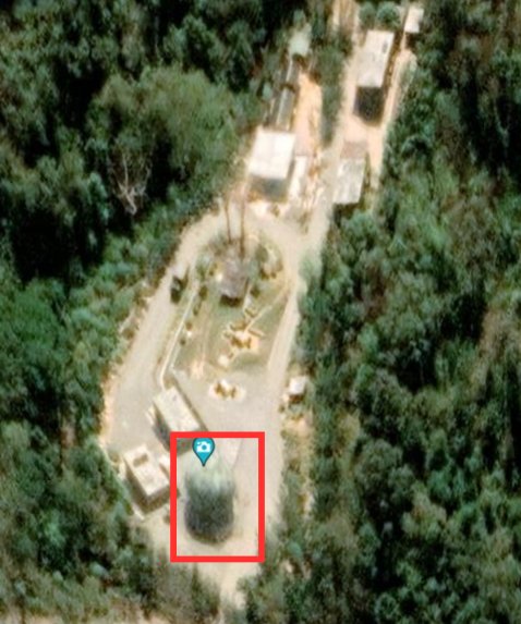
Using high-resolution satellite imagery from Maxar Technologies, Chatham House researchers identified extensive infrastructure development on Great Coco Island, including:
- The extension of a runway from 1,300 metres to approximately 2,300 metres, long enough to accommodate transport and surveillance aircraft;
- Construction of two new aircraft hangars;
- Installation of radomes — dome-like structures that typically house radar or communication equipment;
- And new administrative and support buildings that could house military or technical personnel.
The report suggested that these upgrades could be consistent with SIGINT or electronic intelligence (ELINT) operations, potentially aimed at monitoring Indian naval movements and missile tests.
Shortly thereafter, Australia’s Strategic Policy Institute (ASPI) and other open-source intelligence groups, including AllSource Analysis, corroborated these findings, observing further developments in radar and communication installations.
Their conclusions were stark — the Coco Islands may represent a new node in China’s expanding Indian Ocean surveillance architecture, complementing its facilities in Djibouti, Gwadar (Pakistan), and Hambantota (Sri Lanka).
Myanmar’s Denials — and India’s Frustrations
In response to mounting scrutiny, Myanmar’s military government has repeatedly assured India that no Chinese personnel or facilities exist on Great Coco Island.
During a high-level visit to Naypyidaw in September 2025, India’s Defence Secretary Rajesh Kumar Singh was reportedly told that “not a single Chinese national” was stationed on the islands.
However, the junta simultaneously refused India’s long-standing request to allow an inspection visit by the Indian Navy or defence officials, citing “security and sovereignty concerns.”
This refusal has only deepened Indian mistrust.
Sources familiar with the matter revealed that India had submitted multiple diplomatic and military requests to visit the Coco Islands — all of which have gone unanswered.
Such silence, Indian analysts argue, suggests either Chinese involvement or at least a reluctance by Myanmar to antagonize Beijing by permitting a joint verification.
India’s concerns are compounded by reports that Myanmar’s military has undertaken massive construction projects on the island, including new barracks for over 1,500 personnel and a causeway linking Great Coco and Jerry Islands, which could facilitate logistics and radar network expansion.
The Bay of Bengal: A New Theatre in the Sino-Indian Rivalry
The Bay of Bengal has quietly become one of Asia’s most strategic maritime frontiers.
For India, it is both a gateway to the Indo-Pacific and a defensive buffer shielding its eastern seaboard.
For China, however, it represents the western flank of its maritime Silk Road and a critical route for energy imports from the Middle East and Africa.
Through the Belt and Road Initiative (BRI) and the China–Myanmar Economic Corridor (CMEC), Beijing has gained a foothold in the Bay via Kyaukphyu Port, which provides China with direct access to the Indian Ocean without transiting the vulnerable Malacca Strait.
If Beijing were to enhance its intelligence-gathering capacity from Great Coco Island, it could potentially create a real-time surveillance loop covering the eastern Indian Ocean, including India’s naval operations and U.S. movements from Diego Garcia.
This would mark a major leap in the PLA’s Intelligence, Surveillance, and Reconnaissance (ISR) reach — a critical enabler for future maritime operations.
India’s Countermeasures: Fortifying the Andaman and Nicobar Command
New Delhi has not remained passive in the face of these developments.
In recent years, India has accelerated the modernization of its Andaman and Nicobar Command (ANC) — its only tri-service command and the spearhead of its eastern maritime strategy.
Key initiatives include:
- Upgrading runways at Car Nicobar, Shibpur, and Campbell Bay to support P-8I maritime patrol aircraft and C-130J transport operations;
- Deploying coastal radar chains and electro-optical sensors capable of tracking surface and aerial movements across the Bay;
- Enhancing submarine base infrastructure at INS Baaz and INS Kohassa to host advanced Scorpène-class and nuclear-powered submarines;
- And deepening military integration with Quad partners — the United States, Japan, and Australia — through regular naval exercises such as Malabar.
By enhancing surveillance and quick-response capability in the Andaman Sea, India aims to neutralize any potential Chinese advantage emanating from the Coco Islands or other “String of Pearls” outposts.
China’s Broader Maritime Intelligence Network
If confirmed, the Coco Islands installation would fit seamlessly into Beijing’s expanding maritime intelligence ecosystem across the Indo-Pacific.
China already operates a logistics and SIGINT facility in Djibouti, allowing it to monitor Red Sea and Arabian Sea traffic.
Further east, Beijing maintains access to commercial ports in Gwadar (Pakistan) and Hambantota (Sri Lanka) — both equipped with dual-use capabilities and linked to the PLA Navy’s Yuan-class submarine deployments.
In Southeast Asia, reports of Chinese radar installations in Cambodia’s Ream Naval Base have drawn U.S. and ASEAN concern.
The alleged base on Great Coco Island, if true, would extend China’s intelligence chain to the very doorstep of India’s eastern naval command — giving it unprecedented visibility into India’s SSBN patrols, missile launches, and fleet exercises.
This potential triangulation between Ream, Coco, and Gwadar could give Beijing a formidable maritime surveillance footprint covering nearly the entire northern Indian Ocean.
Myanmar’s Tightrope: Between Beijing and New Delhi
For Myanmar’s military junta, balancing relations between its two powerful neighbours — China and India — has become an intricate diplomatic dance.
Since the 2021 coup, international sanctions and Western isolation have pushed Naypyidaw further into China’s economic embrace.
Chinese investments in the Kyaukphyu deep-sea port, pipelines, and industrial zones have become lifelines for the junta’s struggling economy.
Yet Myanmar also depends on Indian cooperation for border security, counterinsurgency operations, and access to humanitarian supplies.
Analysts believe that Myanmar’s reassurances to India are largely performative, intended to placate New Delhi while avoiding any public friction with Beijing.
In practice, the junta’s refusal to allow inspection of the Coco Islands indicates deference to Chinese sensitivities and an unwillingness to jeopardize the relationship with its most crucial international backer.
Military-Technical Perspective: What a SIGINT Base Could Mean
If China indeed operates — or supports — facilities on Great Coco Island, the implications are significant.
A typical SIGINT station includes long-range antenna arrays, radar tracking systems, satellite communication uplinks, and computer systems capable of decrypting or triangulating signals across multiple frequency bands.
Such installations can monitor electronic emissions from ships, submarines, aircraft, and missile tests over hundreds of kilometres.
By analysing telemetry data from India’s missile trials — including the Agni and K-4 series — Chinese analysts could potentially infer performance parameters such as range, thrust vectoring, and re-entry characteristics.
Moreover, such a base could provide early warning of Indian naval deployments, enabling China to better coordinate its own operations in the Indian Ocean or South China Sea.
Even if the base is nominally controlled by Myanmar, Chinese technical advisers and equipment could still be embedded discreetly under bilateral “training” or “infrastructure support” agreements.
Global Repercussions: The Indo-Pacific Angle
The alleged Chinese presence on the Coco Islands has drawn the attention of Western powers concerned about Beijing’s expanding maritime intelligence network.
The United States and Japan, both members of the Quad alliance with India and Australia, have increased their own ISR activities in the eastern Indian Ocean.
The U.S. Indo-Pacific Command (INDOPACOM) has also stepped up satellite and aerial monitoring of the region, particularly after 2023, when images began circulating of runway expansions and radar domes on Great Coco Island.
Washington views such developments as part of a broader PLA effort to project power westward, securing its sea lines of communication and establishing “eyes and ears” across key maritime chokepoints.
Analysts at the RAND Corporation and the Center for Strategic and International Studies (CSIS) warn that a confirmed SIGINT outpost on Coco Island would shift the intelligence balance in the Bay of Bengal and potentially trigger countermeasures by the Quad, including enhanced joint surveillance and underwater sensor deployments.
A Shadow War in the Indian Ocean
As of October 2025, no conclusive proof has emerged confirming that China operates a spy base on Great Coco Island.
However, the combination of satellite imagery, strategic logic, and Myanmar’s opaque behaviour keeps the suspicion alive.
For India, the mere possibility of Chinese electronic ears so close to its Andaman frontier represents a serious threat to national security.
For Myanmar, the episode underscores its precarious position — trapped between economic dependency on China and the need to maintain cordial ties with India.
For Beijing, it reflects the success of a long-term strategy to extend its maritime intelligence and influence deep into the Indian Ocean, challenging India’s traditional dominance in its own backyard.
The saga of Great Coco Island encapsulates the new reality of the Indo-Pacific — a region where every radar dome, runway, or hangar can become the flashpoint of geopolitical rivalry.
In the shadow of the Bay of Bengal’s turquoise waters, a silent intelligence war is unfolding — one that could redefine the strategic equilibrium of South and Southeast Asia for decades to come.
The intensifying rivalry over the Coco Islands also mirrors the larger contest for supremacy between the Indian Navy and the rapidly expanding People’s Liberation Army Navy (PLAN), which has increased its deployments of Yuan-class submarines and Type-815G electronic surveillance vessels in the eastern Indian Ocean.
Defence analysts note that Beijing’s persistent presence of survey ships and “research vessels” in the Bay of Bengal provides valuable hydrographic data that could be used for future submarine or underwater drone operations, tightening China’s undersea situational awareness near India’s critical maritime approaches.
For New Delhi, this growing Chinese maritime footprint has prompted an accelerated expansion of its Information Management and Analysis Centre (IMAC) network and a stronger integration of space-based maritime surveillance systems with friendly navies under the Quad framework.
Regional observers also warn that any confirmed Chinese military infrastructure on Great Coco Island could compel India to fortify its Andaman and Nicobar Command further — including the potential deployment of long-range surface-to-air missiles and anti-ship missile batteries as deterrents.
Ultimately, the shadow war over the Coco Islands is not just about intelligence gathering but about shaping the balance of power across the entire Indian Ocean, where information dominance, not just naval strength, will define strategic superiority in the decades ahead. — DEFENCE SECURITY ASIA