
Pakistan Withdraws Air Routes “Ground To Unlimited” In Rare Night Window — Signature Analysts Link To Live Missile Employment
Islamabad's aviation authority withdrew multiple ATS route segments from ground level to unlimited altitude across a 0200–0700 nocturnal band on 23–24 July 2026 — a vertical exclusion architecture that professional planners associate with live weapons employment, not civil traffic management. The reconstructed corridor runs from the Afghan frontier near Quetta, Zhob and Wana eastward through Dera Ismail Khan, Layyah and Bhakkar into central Punjab.

(DEFENCE SECURITY ASIA) — Pakistan’s aviation authorities have withdrawn multiple air traffic service route segments from ground level to unlimited altitude across the country’s western and central corridors, a vertical exclusion architecture that professional aviation planners overwhelmingly associate with live weapons employment rather than with any form of routine civil traffic management.
The temporary notice, circulated in open-source channels as A0441/26, applied across 23–24 July 2026 within a compressed 0200–0700 window, a nocturnal band that concentrates military activity into the period of lowest civil traffic density while maximising sensor performance, observation quality and range-safety control.
The distinction between a route-segment withdrawal and a national airspace closure is operationally decisive, because the former preserves civil throughput on alternate tracks and adjacent flight levels, while the latter would constitute a national alert measure carrying immediate and unmistakable diplomatic consequence.

The plotted corridors, reconstructed by open-source analysts from a geo-referenced overlay rather than from authenticated primary aeronautical text, run from the Afghanistan frontier near Quetta, Zhob and Wana eastward through Dera Ismail Khan, Layyah and Bhakkar into the agricultural heart of central Punjab.
That axis terminates within the operational hinterland containing Multan, Faisalabad, Sargodha and Mianwali, a dense concentration of fighter basing, logistics infrastructure and industrial depth that no serious defence analyst can rationally separate from the underlying geometry of the restriction itself.
Pakistan Airports Authority has previously characterised comparable measures as driven by “standard operational reasons,” a deliberately elastic formulation that neither confirms nor excludes weapons testing and functions as institutional ambiguity within an established South Asian escalation-management vocabulary.
No Inter-Services Public Relations statement, no Pakistan Air Force confirmation and no Pakistan Airports Authority clarification had attached a named exercise, weapons programme or operational event to this specific notice as of early 24 July 2026, leaving declared intent formally and conspicuously absent.
That absence is itself an analytical data point, because Islamabad has historically publicised successful Fatah-series training launches retrospectively through Inter-Services Public Relations, meaning silence during the window remains equally consistent with an unannounced test or a purely aerial training package.
The corridor’s eastern reach toward the international border materially compresses Indian early-warning decision timelines, because any ballistic or cruise trajectory launched westward and flown eastward inside that envelope remains indistinguishable from a genuine strike profile until terminal behaviour finally resolves the ambiguity.
That ambiguity is structural rather than incidental, since conventional deep-strike systems and their associated exercise profiles now constitute the primary physical instrument through which both nuclear-armed states communicate resolve, capability and restraint below the nuclear threshold.
For global carriers, the immediate practical consequence is fuel-burn attrition, crew-duty recalculation and slot disruption across already degraded Asia–Europe routings, an accumulating commercial cost layered directly atop the reciprocal India–Pakistan nationality bans extended toward late August 2026.
The strategic question confronting analysts in New Delhi, Beijing, Riyadh and Washington is therefore not whether a five-hour restriction inconvenienced aviation, but precisely what force-posture maturation it quietly validated inside Pakistan’s rapidly consolidating conventional counterforce architecture.
THE NOTAM ARCHITECTURE: WHY “GND–UNL” IS A WEAPONS SIGNATURE, NOT A TRAFFIC MEASURE
A restriction extending from ground level to unlimited altitude deliberately removes the layered vertical deconfliction that normally permits civil traffic to overfly military activity unimpeded, and that removal remains the clearest available technical signature of a projectile leaving and subsequently re-entering the atmosphere.
Fighter training rarely requires genuinely unlimited vertical clearance, because air combat manoeuvring, low-level ingress rehearsal and suppression-of-enemy-air-
Guided rocket artillery and ground-launched cruise systems generate categorically different requirements, since ballistic apogee in the former case and terminal manoeuvring in the latter both demand a cleared volume along the entire predicted flight path plus substantial lateral dispersion margins.
The five-hour duration argues strongly against a sustained multi-package exercise and toward a discrete event or tightly grouped series of events, because major air campaigns typically require repeated multi-day windows to complete meaningful sortie generation and regeneration cycles.
Sequencing matters considerably, because the 0200–0700 slot deliberately places activity after the westbound Gulf departure bank has cleared and before the morning domestic wave begins, minimising rerouting friction while exploiting the most stable atmospheric conditions available.
Route-segment withdrawal rather than blanket national closure also preserves political deniability, because civil aviation continues visibly and verifiably functioning across the wider flight information region while a bounded corridor is quietly sterilised for whatever is being flown or fired inside it.
The absence of authenticated primary NOTAM text in the public domain constitutes a genuine evidentiary gap, and any analysis constructed upon a circulated screenshot overlay necessarily inherits every geolocation and plotting error introduced by whoever originally rendered that imagery.
Analysts should therefore treat the corridor geometry as approximately rather than precisely known, with the broad east–west axis considerably more defensible as a finding than any specific claim regarding individual waypoints, segment designators or exact lateral boundary limits.
Comparable notices issued during March and early July 2026 covering the Karachi and Lahore flight information regions were subsequently characterised by authorities as entirely routine, establishing a documented baseline against which the current event registers as elevated but not genuinely unprecedented.
What distinguishes A0441/26 within that baseline is the specific combination of full vertical extent, multi-segment lateral coverage and an orientation aligned toward the precise frontier where any deterrence signalling inevitably carries the highest possible interpretive weight.

GEOGRAPHY AS INTELLIGENCE: MUSHAF, MIANWALI AND THE EAST–WEST FIRING CORRIDOR
PAF Base Mushaf at Sargodha remains the enduring centre of gravity for Pakistani air power, hosting the force-multiplier assets, hardened infrastructure and advanced combat training apparatus that anchor virtually any large-scale strike package rehearsal the service undertakes.
PAF Base M.M. Alam at Mianwali contributes operational conversion and advanced training capacity to that architecture, and its position astride the Indus corridor places it directly within the eastern segments of the plotted restriction as reconstructed by analysts.
The intervening terrain across Layyah, Bhakkar and the wider Thal desert belt offers precisely the sparsely populated, radar-clean and infrastructure-light ground that live-fire ranges and low-level ingress rehearsals require without generating unacceptable civilian casualty risk.
Dera Ismail Khan sits at the operational hinge between the western counter-insurgency theatre and the eastern conventional theatre, making its inclusion entirely consistent with either mission set and therefore diagnostically weak when assessed in isolation from other indicators.
Quetta, Zhob and Wana anchor the western terminus near the Afghanistan frontier, a segment that could equally support launch-basket clearance for a westward firing point or protective airspace management above continuing intelligence-based ground operations across Balochistan and Khyber Pakhtunkhwa.
Strategic depth is the operative concept throughout, because a west-to-east firing geometry maximises the Pakistani territorial buffer standing behind the launcher while ensuring predicted impact areas remain firmly inside national territory rather than anywhere near a contested frontier.
That geometry effectively mirrors deep-strike doctrine in reverse, rehearsing the exact ranges, flight times and command sequences required for eastward employment while keeping the physical event entirely domestic, legally unimpeachable and diplomatically defensible under international norms.
The coastal Sonmiani range complex, which carries its own separate and considerably longer daytime July notices, remains Pakistan’s primary maritime-facing test facility, and its apparent exclusion from this particular restriction suggests an inland trajectory profile was contemplated instead.
Inland testing imposes measurably stricter overflight safety demands and therefore stricter airspace management obligations, which coherently explains why a full ground-to-unlimited exclusion was assessed as necessary rather than a conventional upper-level or block-altitude reservation.
Force-posture analysis of the corridor consequently yields an internally consistent picture: a mature, distributed test-and-training infrastructure exercising interior lines across effectively the entire operational width of the Pakistani state in a single compressed window.
THE FATAH QUESTION: ARMY ROCKET FORCE COMMAND AND CONVENTIONAL DEEP-STRIKE DOCTRINE
Army Rocket Force Command was established as Pakistan’s institutional answer to a widening conventional-precision gap, consolidating guided rocket artillery and ground-launched cruise systems beneath a single deep-strike headquarters with dedicated targeting, survivability and dispersal doctrine.
The Fatah family developed by NESCOM spans the Fatah-1 and Fatah-II guided multiple-launch rocket systems across an approximate 140 to 400 kilometre band, delivering corps and theatre-level reach with substantially reduced circular error probable against fixed high-value targets.
Fatah-IV extends that architecture into ground-launched cruise missile territory at a reported 750 kilometre range, converting what began as tactical rocket artillery doctrine into a genuine operational-depth instrument capable of holding rear-area logistics and command nodes at risk.
Reported Fatah-5 concepts approaching 950 to 1,000 kilometres, discussed extensively in 2026 defence analyses but not independently verified by any authoritative source, would push the family into a strategic-conventional band overlapping targets historically reserved exclusively for manned aircraft.
The doctrinal significance is that precision conventional rockets permit Pakistan to answer Indian conventional superiority without invoking nuclear signalling, deliberately widening the sub-threshold operational space within which any future crisis could be prosecuted, contained and terminated.
Each incremental range extension simultaneously complicates Indian air and missile defence allocation, because a saturating salvo of guided rockets and cruise missiles arriving on divergent azimuths depletes finite interceptor inventories far faster than equivalent manned aircraft raids.
Inter-Services Public Relations publicly announced a successful Fatah-IV training launch during mid-May 2026, establishing both the system’s declared operational status and Islamabad’s demonstrated willingness to advertise strike capability at moments deliberately chosen for maximum political effect.
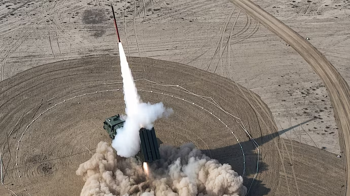
Open-source material circulated alongside the July notice included video of a rocket ascending from a ground launcher across arid terrain, imagery entirely consistent with Fatah-series employment yet falling considerably short of any evidentiary standard approaching confirmation.
Corroboration standards matter acutely here, because launcher footage of this generic type is routinely recycled from earlier publicised events and therefore cannot responsibly be treated as evidence of activity occurring within the specific 23–24 July window.
The defensible analytical conclusion is capability continuity rather than capability revelation, with the notice most plausibly supporting validation of accuracy, sub-system integration or crew procedures already demonstrated during earlier trials conducted throughout the preceding months of 2026.
AIRSPACE AS AN INSTRUMENT OF STATECRAFT: RECIPROCAL BANS AND THE ECONOMICS OF CLOSURE
Airspace has become a genuinely contested medium across South Asia entirely independent of any shots being fired, with reciprocal nationality-based bans now functioning as sustained economic pressure instruments rather than as any recognisable tactical military measure.
Pakistan’s extension of Karachi and Lahore flight information region unavailability to Indian-registered aircraft, Indian operators and associated military flights toward late August 2026 continues an unbroken cycle of renewals running continuously since the middle of 2025.
India’s reciprocal measure imposes the precise mirror cost, forcing Pakistani operators into significantly extended routings while Indian long-haul carriers simultaneously absorb additional block time across westbound European and North American sectors that previously transited Pakistani upper airspace.
Those nationality-based closures are categorically different from A0441/26, because bans exclude specific operators indefinitely while route-segment notices exclude all traffic briefly, and conflating the two systematically distorts any serious regional threat assessment.
The commercial arithmetic nonetheless compounds relentlessly, since a widebody airliner burning roughly five to six tonnes of fuel every hour converts each additional half-hour of imposed routing into an immediate four-figure dollar penalty on every affected sector.
At indicative mid-2026 jet fuel pricing, a single additional hour on a long-haul rotation can plausibly approach USD 6,000 to USD 8,000, equivalent to approximately RM22,800 to RM30,400 at an exchange rate of RM3.80 to the dollar.
Multiplied across daily frequencies and then annualised across an entire network, such penalties readily reach eight-figure dollar exposure for major carriers, a logistics footprint consequence rarely featured in strategic commentary yet decisively shaping airline lobbying behaviour.
Those figures are explicitly illustrative order-of-magnitude estimates rather than audited operator data, and no verified cost assessment attributable to the specific July restriction has been published by any airline, regulator or aviation industry body.
For Southeast Asian and Gulf carriers routing between East Asia and Europe, Pakistani corridor availability functions as a structural network planning variable, granting Kuala Lumpur, Singapore and Doha a material commercial stake in continued South Asian stability.
Airspace management has consequently become an instrument of statecraft in which civil aviation silently absorbs the accumulated friction generated by military signalling that neither operators nor passengers have any conceivable role in producing or preventing.
ESCALATION MANAGEMENT: SIGNALLING, AMBIGUITY AND THE INDO-PACIFIC READ-ACROSS
Deterrence signalling functions only when the intended audience can actually observe it, and a publicly disseminated notice restricting airspace along an axis oriented toward a rival frontier is observable by deliberate design rather than by administrative accident.
Indian analysts will inevitably read the corridor’s eastward orientation as rehearsal geometry for operational-depth strike, regardless of whether Pakistani planners intended any message beyond straightforward compliance with domestic range safety and civil aviation obligations.
That interpretive asymmetry constitutes the core escalation risk, because signals received consistently prove more consequential than signals sent when both militaries operate on severely compressed warning timelines across a subcontinent offering minimal geographic depth.
Flight times measured in single-digit minutes across the international border leave almost no room for diplomatic clarification once a launch is detected, placing extraordinary institutional weight on pre-notification regimes and functioning military-to-military communication channels.
Existing bilateral arrangements cover ballistic missile flight testing reasonably well but sit uneasily around guided rocket artillery and cruise systems, a legal and definitional gap that widens materially with every incremental extension of Fatah-series range.
Cruise missiles prove additionally destabilising because their low-altitude terrain-following profiles systematically defeat long-range early warning radar coverage and blur the operational distinction between rehearsal and execution until dangerously late in the engagement timeline.
Continuing domestic security operations across Balochistan and Khyber Pakhtunkhwa provide an alternative and entirely non-escalatory explanation for the western corridor segments, and analysts should firmly resist collapsing all observed activity into a single India-facing narrative.
Equal scepticism must be applied to Indian characterisations of Pakistani testing and to Pakistani characterisations of routine operational necessity, since both governments actively manage their information environments for demonstrable strategic and domestic political advantage.
For Indo-Pacific observers, the transferable lesson is that conventional precision-strike proliferation is measurably compressing decision timelines within every regional dyad, extending from the Taiwan Strait and the South China Sea to the Korean Peninsula.
The five hours of restricted airspace above Punjab therefore matter considerably less as an aviation event than as a visible, dated increment in the slow and systematic construction of a survivable conventional deep-strike posture.

Appreciate, Could you explain how India still manages to strike terrorist sites so precisely while avoiding major Pakistani military installations, despite Pakistan’s air defense, rocket force, and airspace restrictions?