Pakistan’s Reported ‘Ababeel’ Drone-Hovercraft Buildup Near Sir Creek Raises India-Pakistan Tensions as China and Türkiye Reshape Arabian Sea Power
Pakistan’s reported deployment of special forces, Turkish drones, hovercraft, fast boats and layered coastal defences near Sir Creek could reshape India-Pakistan deterrence and expand the strategic contest across the Arabian Sea.
(DEFENCE SECURITY ASIA) — Pakistan’s reported deployment of special forces, armed-capable drones, hovercraft, fast boats and layered coastal defences near Sir Creek could transform the disputed estuary from a static boundary into a technologically contested littoral battlespace.
The alleged expansion, reportedly organised under “Ababeel—The Divine Strike,” would strengthen Pakistan’s surveillance, rapid-response and area-denial capabilities along the India-Pakistan maritime frontier, although the complete deployment package remains unverified and officially unconfirmed.
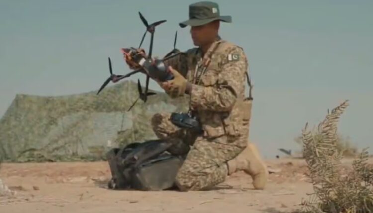
Claims emerging in early August 2026 describe Pakistan Navy Special Service Group commandos operating alongside Turkish drones, Chinese equipment and newly established marine posts between Bandha Dhora and Harami Dhoro near the creek system.

No independently released satellite imagery, official deployment order or detailed confirmation from Pakistan, China or Türkiye presently substantiates every reported component, requiring the distinction between confirmed modernisation and politically consequential intelligence claims to remain explicit.
However, Pakistan Navy’s official promotional video titled “ABABEEL …. The Divine Strike,” released on July 1, 2026, displayed Marines, drones, beach landings and target engagements, confirming that the designation exists within an amphibious-operational context.
Pakistan also confirmed the October 2025 induction of three 2400 TD hovercraft into its Marines after Chief of the Naval Staff Admiral Naveed Ashraf inspected forward positions and operational readiness across the Creeks Area.
Their arrival established a credible mobility foundation for operations across mudflats, sandbanks, shallow channels and tidal marshes where conventional patrol craft, wheeled vehicles and heavier amphibious platforms face severe navigational and logistical limitations.
The reported combination of unmanned aerial vehicles, unmanned surface systems, special-operations personnel, rockets and air-defence assets would create an interconnected surveillance-strike architecture rather than merely adding isolated platforms to Pakistan’s existing coastal inventory.
Such a force posture could compress India’s warning time, complicate target classification and enable Pakistan to maintain persistent presence without exposing large conventional formations within a geographically constrained and politically sensitive maritime boundary.
Field Marshal Asim Munir’s reported oversight connects the alleged buildup with Pakistan’s broader unified-command modernisation, including its emerging Army Rocket Force, submarine expansion and acquisition of Chinese-built surface combatants for Arabian Sea operations.
India is simultaneously reinforcing the sector, including through a July 2026 request for 11 indigenous high-speed amphibious combat boats configured for Sir Creek and Harami Nala, demonstrating reciprocal adaptation rather than unilateral escalation.
The emerging contest therefore concerns more than sovereignty over a 96-kilometre estuary, because Sir Creek influences Exclusive Economic Zone claims, Karachi’s eastern approaches, Gujarat’s coastal security and the wider India-Pakistan balance in the Arabian Sea.
Ababeel’s Unverified Deployment Architecture
The most consequential reports describe elite Pakistan Navy Special Service Group personnel positioned within the Sir Creek sector, providing specialised reconnaissance, interdiction and rapid-response options across land, air and water in exceptionally restrictive terrain.
SSG-N deployment would represent a qualitative force-posture change because maritime commandos can exploit concealed channels and dispersed coastal positions while supporting drone operations, forward surveillance and limited missions without requiring conspicuous troop concentrations.
Turkish drones reportedly assigned to surveillance and explosive-payload missions could extend Pakistan’s observation radius beyond fixed posts, enabling continuous monitoring of waterways, patrol patterns and temporary routes created by shifting tides across the marshland.
Whether these aircraft constitute reconnaissance platforms, weaponised unmanned combat aerial vehicles or one-way attack systems remains undisclosed, preventing reliable assessment of their endurance, payload, datalinks, electronic-warfare resistance or operational command arrangements.
Reports also identify Chinese hovercraft, fast naval boats, marine assault craft and unmanned surface vehicles, but the platforms’ origins remain uncertain because confirmed 2400 TD hovercraft have elsewhere been associated with refurbished British Griffon designs.
This discrepancy matters because payload capacity, range, maintenance requirements and sea-state limitations determine whether Pakistan can sustain dispersed patrols, transport commandos, resupply isolated positions or establish an effective cross-creek operational network.
Multiple security posts reportedly constructed between Bandha Dhora and Harami Dhoro could support sensors, communications relays, fuel, personnel rotation and drone control, creating the logistical spine required for persistent rather than episodic military presence.
Rocket and air-defence systems allegedly coordinated with Pakistan’s emerging Army Rocket Force would expand the deployment beyond constabulary patrolling by protecting forward assets and potentially holding Indian staging areas, vessels or infrastructure at operational risk.
Nevertheless, no evidence presently demonstrates mass mobilisation, concentrated artillery, large ammunition movements or offensive staging normally associated with imminent conventional operations, making coercive signalling and deterrence the more supportable interpretations.
Ababeel consequently appears, pending verification, to represent an integrated littoral concept combining mobility, unmanned surveillance, precision engagement and distributed defence, while uncertainty surrounding its scale prevents definitive conclusions about Pakistan’s immediate operational intentions.

Hovercraft Transform Marshland Mobility
The confirmed induction of three 2400 TD hovercraft provides the strongest material evidence behind Pakistan’s expanding Sir Creek posture because these platforms can traverse shallow water, exposed mud, marsh vegetation and unstable tidal surfaces.
Conventional boats depend upon navigable channels whose depth and alignment change continuously, whereas air-cushion vehicles can bypass several hydrographic constraints, creating alternative approaches that complicate Indian surveillance, interception planning and defensive prediction.
Hovercraft could transport Marines, communications equipment, light weapons and supplies between dispersed outposts while reducing dependence upon permanent roads, deep-water jetties or predictable boat routes vulnerable to observation and interdiction.
This mobility directly supports distributed operations, allowing Pakistan to reposition small units quickly, reinforce threatened locations and withdraw personnel before India can concentrate patrol craft or ground forces against a detected presence.
Admiral Naveed Ashraf’s 2025 readiness inspection and declared commitment to defending maritime frontiers “from Sir Creek to Jiwani” linked local creek capabilities with Pakistan’s wider coastline, extending the operational narrative beyond one disputed estuary.
The phrase connected the easternmost contested waterways with Jiwani near Pakistan’s western frontier, signalling that Islamabad views Marines and littoral platforms as components of a national coastal-defence architecture spanning the northern Arabian Sea.
Operational effectiveness will nevertheless depend upon maintenance, spare parts, crew proficiency, navigation in poor visibility and protection against drones, electro-optical sensors and precision weapons, none of which is guaranteed by platform induction alone.
Hovercraft also possess identifiable acoustic, infrared and visual signatures, meaning mobility advantages could diminish when confronted by persistent aerial surveillance, networked coastal sensors or armed unmanned systems operating above the marshes.
Their greatest value may therefore lie in logistical unpredictability and rapid tactical access rather than survivability during sustained combat, especially within narrow waterways increasingly observed by both Indian and Pakistani intelligence systems.
Combined with fast boats and drones, however, the platforms could form a multi-domain patrol network in which aerial sensors locate activity, surface craft investigate contacts and hovercraft deliver personnel across otherwise inaccessible ground.
Sir Creek’s Strategic Geography
Sir Creek’s unresolved boundary originates from competing interpretations of colonial-era arrangements, including the 1914 Sindh resolution and disagreement over whether the thalweg principle should divide the navigable channel between India and Pakistan.
Although a 1968 tribunal resolved much of the wider Rann of Kutch dispute, it left Sir Creek unsettled, allowing changing channels, conflicting maps and incompatible legal positions to preserve a strategically exploitable maritime ambiguity.
The disagreement carries consequences beyond the estuary because the accepted land-boundary terminus affects how both states project their maritime limits and Exclusive Economic Zones into potentially valuable areas of the Arabian Sea.
Even a comparatively small movement of the maritime starting point could influence claims over thousands of square kilometres containing fishing grounds, prospective hydrocarbon resources, seabed rights and future offshore infrastructure.
For Pakistan, the sector anchors the eastern flank of approaches toward Karachi, its principal commercial port and a central naval-logistics hub whose security remains critical to national trade, fleet sustainment and economic resilience.
For India, Sir Creek intersects the defence of Gujarat, the Kutch coastline and western maritime approaches, while its difficult waterways have long generated concern regarding infiltration, smuggling and covert movement toward populated coastal areas.
The estuary’s mudflats and tidal channels restrict conventional armoured manoeuvre but reward small craft, Marines, special forces and unmanned systems, making technological adaptation more consequential than simply increasing troop numbers.
Persistent drones could map navigable routes, monitor temporary encampments and cue interception forces, while unmanned surface vehicles could investigate hazardous channels without exposing crews, fundamentally raising the density of local maritime awareness.
That same automation increases miscalculation risks because ambiguous drone movements, lost datalinks or unidentified fast craft may be interpreted as hostile preparation within a boundary whose exact alignment remains politically disputed.
Sir Creek is therefore becoming a laboratory for distributed littoral warfare, where modest platforms can generate strategic effects by shaping sovereignty claims, surveillance coverage, escalation thresholds and access to the northern Arabian Sea.
China, Türkiye and Pakistan’s Naval Modernisation
China’s significance extends beyond any unverified Sir Creek equipment because Pakistan’s wider naval transformation already includes Chinese-built Tughril-class frigates and Hangor-class air-independent-propulsion submarines intended to strengthen sustained Arabian Sea operations.
These acquisitions provide Islamabad with modern sensors, missiles, underwater endurance and fleet interoperability, progressively shifting Pakistan Navy from predominantly coastal defence toward sea denial, extended patrols and protection of strategically important maritime approaches.
If Chinese-origin craft or surveillance systems are confirmed near Sir Creek, their deployment would demonstrate how major naval partnerships can transfer technology from blue-water modernisation into highly specialised shallow-water missions along disputed frontiers.
Türkiye contributes a different capability pathway through unmanned aviation and associated defence technologies, potentially giving Pakistan comparatively affordable surveillance persistence, modular payload options and operational experience derived from rapidly evolving drone warfare.
However, the precise Turkish aircraft reportedly deployed remain unidentified, and attributing capabilities without confirmed models would risk overstating their range, weapons capacity, autonomy, electronic protection and suitability for humid coastal conditions.
The Pakistan-Türkiye-China triangle is not necessarily a formal operational alliance, yet complementary acquisitions from both suppliers can reduce Islamabad’s dependence upon Western systems while expanding tactical choices against a technologically capable India.
Such diversification also carries logistical costs because mixed-origin fleets require separate maintenance chains, training standards, munitions inventories, software support and communications integration, potentially limiting availability despite impressive nominal equipment numbers.
Pakistan’s ability to network Chinese naval platforms, Turkish drones, indigenous command structures and legacy Western equipment will determine whether the reported buildup becomes a coherent combat system or remains a collection of specialised assets.
Asim Munir’s unified-command reforms and the proposed rocket-force structure appear designed to improve cross-service coordination, but their operational maturity, targeting architecture and relationship with Pakistan’s established strategic command arrangements remain unclear.
The broader signal is nevertheless unmistakable: Islamabad wants India to account for a more distributed Pakistani force capable of operating underwater, offshore, within coastal zones and across inaccessible terrain under integrated command.
India’s Response and Escalation Risks
India’s request for 11 indigenous high-speed amphibious combat boats represents a direct capability response to Sir Creek’s geography, prioritising shallow-draft mobility, rapid interception and sustained operations within Harami Nala’s difficult waterways.
Indigenous procurement could simplify maintenance and permit modifications based on Indian operational experience, while creating platforms better integrated with Coast Guard, Navy, ground-force and coastal-surveillance networks already covering the Gujarat sector.
India’s response is unlikely to remain platform-specific because countering drones and dispersed craft requires layered radar, electro-optical surveillance, electronic warfare, secure communications and rapid decision-making across military and law-enforcement organisations.
Defence Minister Rajnath Singh’s earlier declaration that “the road to Karachi goes through Sir Creek” introduced strategic coercion into the dispute, although rhetoric alone does not establish Indian intent or an imminent offensive plan.
Pakistan’s visible modernisation may similarly serve domestic reassurance and external deterrence, especially following the 2025 India-Pakistan confrontation, without demonstrating that Islamabad has authorised territorial seizure or sustained combat operations.
Both governments therefore benefit politically from projecting readiness, yet reciprocal deployments can create a security dilemma in which defensive acquisitions appear offensive, producing further surveillance, fortification and high-readiness patrols.
Nuclear deterrence constrains deliberate major escalation but cannot prevent local incidents involving drones, fishermen, patrol boats or special forces, particularly where uncertain boundaries and compressed reaction times complicate command judgement.
The absence of mass formations suggests the present situation remains elevated posturing rather than crisis mobilisation, although specialised forces can generate disproportionate effects before conventional reinforcements or diplomatic mechanisms become available.
Future assessment should focus upon independently verifiable indicators, including new support facilities, communications nodes, ammunition storage, recurring drone activity, hovercraft deployments and integration between Pakistan’s Navy, Marines and rocket forces.
Until such evidence emerges, Ababeel should be understood as a partially confirmed modernisation narrative whose strategic importance lies in how unmanned systems, amphibious mobility and external partnerships are reshaping deterrence around Sir Creek.
