Chinese UUV Discovered in Indonesia’s Strategic Lombok Strait Raises Fears of Secret Undersea Surveillance Network
A CSIC-marked unmanned underwater vehicle recovered inside Indonesia’s ALKI II corridor is intensifying concerns over Chinese maritime intelligence operations in one of the world’s most critical Indo-Pacific chokepoints.

(DEFENCE SECURITY ASIA) — Indonesia’s discovery of a suspected Chinese-origin unmanned underwater vehicle inside the Lombok Strait signals a potential escalation in undersea surveillance competition across one of the Indo-Pacific’s most strategically sensitive maritime corridors linking the Pacific and Indian Oceans.
The recovery of a CSIC-marked underwater system within Indonesia’s Archipelagic Sea Lane II (ALKI II) raises immediate concerns over persistent foreign intelligence collection, as Rear Admiral Tunggul confirmed an ongoing investigation into the device’s origin, operational purpose, and potential stored data.
The incident unfolds amid intensifying regional maritime competition, where unmanned systems increasingly enable covert seabed mapping and acoustic intelligence gathering, creating strategic ambiguity over whether such deployments represent scientific missions or deliberate military reconnaissance operations.
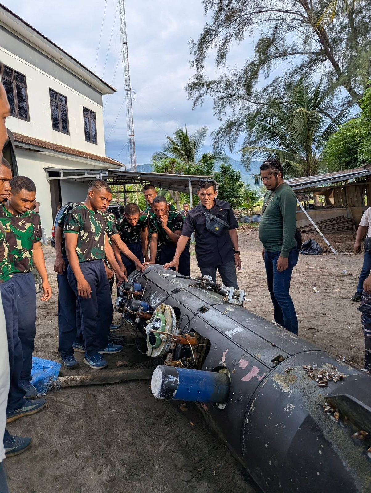
The device was first identified on April 6, 2026, at approximately 10:00 WITA by a local fisherman operating north of Gili Trawangan, whose recovery of the floating system transformed a routine fishing operation into a potential geopolitical flashpoint involving undersea domain awareness.
Located roughly 10 to 16 kilometres within the northern Lombok Strait, the discovery site sits directly inside ALKI II, a legally designated international transit route whose strategic geography makes it a high-value corridor for submarine transit, maritime traffic monitoring, and naval intelligence operations.
The cylindrical UUV, measuring approximately 3.7 metres in length with a diameter of around 70 centimetres, displayed clear hydrodynamic shaping, rear control fins, and sensor-integrated sections consistent with long-endurance underwater gliders designed for persistent oceanographic and surveillance missions.
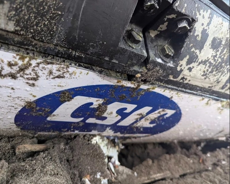
Visible markings on the hull included the “CSIC” logo alongside Chinese characters identifying “中国船舶集团,” directly linking the system to China’s state-owned shipbuilding and defence-industrial ecosystem, despite corporate restructuring into a larger conglomerate structure in recent years.
The presence of marine growth such as barnacles suggests prolonged underwater deployment, indicating that the system had been operating autonomously for an extended period before surfacing or drifting into Indonesian-controlled waters.
No official response has yet emerged from China, increasing speculation that the recovered platform may represent part of a wider, deniable network of underwater surveillance systems operating across Southeast Asia’s most sensitive maritime chokepoints.
For Indonesia, the incident is likely to intensify pressure for expanded anti-submarine surveillance, seabed monitoring, and persistent maritime domain awareness capabilities throughout the Lombok Strait and adjacent archipelagic sea lanes.
READ: China Overtakes U.S. in Nuclear Submarine Production: 79,000-Tonne Surge Reshapes Indo-Pacific Undersea Power Balance
Strategic Importance of the Lombok Strait and ALKI II
The Lombok Strait represents one of the deepest and most navigationally critical passages in Southeast Asia, enabling submarines and large naval vessels to transit between the Pacific and Indian Oceans without the depth constraints imposed by alternative routes such as the Malacca Strait.
Its designation as part of ALKI II institutionalises its role as an international sea lane, but also creates inherent vulnerabilities by permitting foreign vessels transit rights that complicate enforcement against covert underwater surveillance activities.
Control over acoustic environments within such chokepoints directly influences submarine detection capabilities, making detailed seabed mapping and environmental data collection strategically valuable for anti-submarine warfare planning.
The discovery of a UUV in this corridor suggests potential attempts to characterise oceanographic variables such as salinity, temperature gradients, and underwater topography, all of which affect sonar performance and submarine stealth operations.
Such data could be leveraged to enhance the operational effectiveness of submarines transiting through the region, particularly for powers seeking to project naval influence across the Indo-Pacific theatre.
Indonesia’s geographic position as an archipelagic state amplifies the strategic stakes, as its sea lanes form critical connectors in global maritime trade and military mobility, placing it at the centre of competing naval interests.
The Lombok Strait’s depth advantage over the Malacca Strait makes it especially attractive for nuclear-powered submarines and large surface combatants, increasing the incentive for foreign powers to conduct persistent monitoring of its underwater environment.
The detection of a foreign UUV within this zone therefore carries implications not only for Indonesian sovereignty but also for the broader balance of naval power across Southeast Asia.
Technical Characteristics and Likely Mission Profile of the UUV
The recovered system’s torpedo-like configuration aligns with known underwater glider architectures designed for low-power, long-endurance missions that rely on buoyancy changes rather than continuous propulsion.
Such platforms typically operate autonomously for extended durations, collecting environmental data across large distances while maintaining minimal acoustic signatures, making them difficult to detect using conventional naval surveillance methods.
The integration of fins and sensor modules indicates a capability for controlled navigation and multi-parameter data acquisition, potentially including temperature, salinity, and acoustic measurements relevant to submarine operations.
The absence of explosive or hazardous materials, confirmed through Indonesian bomb disposal team scans using specialised detection systems, reinforces the assessment that the platform was designed for intelligence or scientific purposes rather than kinetic operations.
However, the dual-use nature of oceanographic data complicates this distinction, as information gathered for research purposes can directly enhance military planning and operational effectiveness in undersea warfare environments.
The association with CSIC, a major Chinese defence-industrial entity, further raises the probability that the system forms part of a broader network of maritime surveillance assets supporting long-term strategic objectives.
The device’s condition, including evidence of extended submersion, suggests it may have been operating beyond Indonesian awareness for a significant period, highlighting potential gaps in maritime domain awareness.
The lack of publicly released technical specifications by Indonesian authorities indicates that detailed analysis is still ongoing, with potential intelligence value embedded in onboard data storage systems yet to be fully assessed.
Indonesian Response and Sovereignty Implications
Indonesian authorities responded rapidly following the fisherman’s report, deploying naval and police units to secure the site and establish a controlled perimeter around the recovered object.
The involvement of specialised bomb disposal units reflects standard operating procedures for unidentified devices, particularly given the potential risk of concealed hazardous materials or intelligence-gathering equipment.
The confirmation that the device was “sterile” eliminated immediate safety concerns but shifted focus toward its strategic implications and the need for detailed technical analysis.
The evacuation of the UUV to the Mataram Naval Base enabled controlled examination by Indonesian Navy experts, ensuring that sensitive data could be secured and analysed within a secure military environment.
Rear Admiral Tunggul’s statement emphasising Indonesia’s commitment to protecting maritime sovereignty underscores the broader political significance of the incident, particularly in the context of increasing foreign naval activity in regional waters.
The continued presence of a police line and ongoing investigation signals that Indonesian authorities are treating the incident as a matter of national security rather than a routine maritime anomaly.
The absence of definitive conclusions regarding the device’s mission profile reflects both the complexity of such systems and the need for careful analysis before attributing intent.
Indonesia’s response also highlights the challenges faced by archipelagic states in monitoring vast maritime domains where autonomous systems can operate with minimal detection risk.
Recurring Pattern of UUV Discoveries in Indonesian Waters
The Lombok Strait incident is not an isolated case, as similar underwater gliders have previously been recovered in Indonesian waters, including a notable discovery near the Selayar Islands in 2020.
That earlier system was widely identified as a Chinese “Seawing”-type glider, sharing design characteristics with the current device, including torpedo-shaped geometry and integrated sensor arrays.
The recurrence of such discoveries suggests a pattern of persistent deployment of unmanned systems within Indonesia’s maritime domain, raising questions about the scale and coordination of these operations.
Defence observers have noted the frequency of these incidents, sometimes referring to them informally as a recurring phenomenon, although such characterisations mask the serious strategic implications involved.
Repeated findings indicate that these systems may form part of a broader network designed to collect continuous environmental data across key maritime routes.
This pattern reinforces concerns that undersea surveillance operations are becoming increasingly routine in contested maritime environments, leveraging autonomous platforms to minimise political risk.
The lack of official responses from China in such cases contributes to strategic ambiguity, complicating efforts to establish clear norms or accountability mechanisms.
The cumulative effect of these incidents is to elevate the importance of undersea domain awareness as a critical component of national security for maritime states.
Strategic Implications for Indo-Pacific Naval Competition
The deployment of unmanned underwater systems in strategic sea lanes reflects a broader shift toward distributed, autonomous intelligence collection in modern naval operations.
Such capabilities enable states to build detailed environmental datasets that enhance the survivability and effectiveness of submarines and other undersea assets.
In the context of the Indo-Pacific, where maritime chokepoints play a decisive role in shaping military mobility, control over underwater information becomes a key determinant of strategic advantage.
The Lombok Strait’s role as an alternative to the Malacca Strait increases its importance in scenarios involving naval conflict or contested sea lines of communication.
The presence of foreign UUVs within this corridor suggests an effort to reduce uncertainty and improve operational planning for potential future contingencies.
Indonesia’s experience highlights the need for enhanced detection capabilities, including acoustic monitoring networks and integrated maritime surveillance systems.
The incident also underscores the growing complexity of maritime security, where non-kinetic activities such as data collection can have significant strategic consequences.
As autonomous technologies continue to proliferate, the challenge of distinguishing between scientific research and military reconnaissance is likely to become increasingly acute.
Uncertainty, Attribution Challenges, and Future Developments
Despite clear markings linking the device to a Chinese entity, definitive conclusions regarding its mission and operational control remain pending, reflecting the inherent difficulty of attributing intent in undersea activities.
The absence of an official statement from China leaves open multiple interpretations, ranging from benign scientific research to deliberate intelligence collection operations.
Indonesia’s ongoing technical analysis will likely focus on recovering any stored data, which could provide insights into the system’s operational parameters and intended mission.
The potential presence of encrypted data or proprietary software systems may complicate efforts to extract actionable intelligence from the device.
Future developments will depend on Indonesia’s assessment outcomes and any subsequent diplomatic engagement with relevant stakeholders.
The incident may also prompt broader regional discussions on the regulation of unmanned systems and the protection of maritime sovereignty in international sea lanes.
As undersea technologies continue to evolve, the balance between transparency, security, and operational secrecy will remain a central challenge for Indo-Pacific maritime governance.
The Lombok Strait discovery therefore represents not only a specific security incident but also a broader indicator of emerging trends in undersea competition and strategic positioning.